Addresses
Type of place
House
Period
Federation 1890-1914
Style
Queenslander
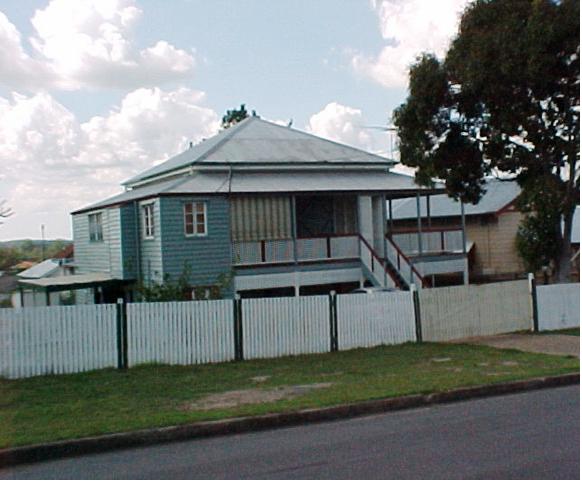

This is an image of the local heritage place known as Residence 'Chester House'
Chester House
Addresses
Type of place
House
Period
Federation 1890-1914
Style
Queenslander
This house was built circa 1902 for the Malcolm family when Mt Gravatt was still a predominantly rural area. The Malcolms lived in the house for only a few years before selling it to George Chester. In the postwar era, Chester led the housing estate boom in Mt Gravatt by opening up 25 acres of land for sale in ‘Chester Estate,’ which essentially began the urbanisation of the area. This timber and tin house is believed to be the oldest surviving house in Mt. Gravatt.
Lot plan
L2_SP132480
Key dates
Local Heritage Place Since —
Date of Citation —
Construction
Roof: Corrugated iron;Walls: Timber
Criterion for listing
(A) Historical; (B) RarityInteractive mapping
Lot plan
L2_SP132480
Key dates
Local Heritage Place Since —
Date of Citation —
Construction
Roof: Corrugated iron;Walls: Timber
Criterion for listing
(A) Historical; (B) RarityInteractive mapping
History
The land on which this residence was built was originally part of a crown land purchase made by Thomas Illidge on 16 June 1870. Illidge, a resident of Brisbane Town paid ₤11 for 40 acres of land described as Portion 328 that was part of Selection 999 in the Parish of Bulimba. On 31 December 1877, Illidge transferred the undeveloped land to Donald Mackay. Mackay held the land until 3 July 1882, when he sold Portion 328 to Frederick Lumley Henzell. Henzell may have paid for his purchase through a mortgage that he took out on the land. For on the date of the sale, Henzell mortgaged Portion 328, obtaining ₤200 from Albert Rudolph Hugo Hetzecker. In 1883, Henzell subdivided Portion 328 into small farm allotments and then conducted a land sale.
On 14 March 1888, Henzell sold subdivisions 1 to 8 of section 4 of Portion 328 to Henry Clayton. Clayton had acquired 1 acre and 34 perches of farmland. He transferred ownership to Philip Clayton on 27 February 1894. For reasons that remain unknown, Henry Clayton took back the land on 8 September 1896.
Catherina Murray Malcolm bought the land from Clayton on 24 October 1901. Catherina was the wife of Michael George Malcolm and it is thought that the Malcolms built the residence at 7 Ballarat Street. William Malcolm is first listed as a resident of “Broadwater” at Mt Gravatt in the 1902 edition of the Queensland Post Office Directories. The information for each edition of these directories was compiled during the year prior to publication so it would seem that the Malcolms were receiving mail at their new home as early as 1901. The fact that they obtained a mortgage of ₤75 from Michael John McGeary on 19 September 1902, may indicate that they used this loan to complete the construction of their house, the front entrance of which, faced Broadwater Road. Thus the date of construction of the house is considered to be 1902.
On 9 June 1906, the Malcolms sold the house and land to Thomas Chester. Chester was a green grocer who ran a shop on Logan Road, Woolloongabba. The Chester family was to have a major influence upon the conversion of Mt Gravatt from farming district to modern suburb. George Chester followed the family business by becoming a fruit hawker and then a banana grower. For a time he ran a sawmill at Pimpama but in 1949 he purchased 25 acres of land in Mt Gravatt. He subdivided this land into housing allotments and he built 400 homes and 13 shops that became the nucleus of the Mt Gravatt shopping precinct. He sold the house and land packages under the banner of “Chester Estate” which was the beginning of the urbanisation of Mt Gravatt.
The “Chester House” at 7 Ballarat Street, was identified as a heritage place by the Mt Gravatt Historical Society in their Heritage Tour book Jump On The Bus published in 1999.
Statement of significance
Relevant assessment criteria
This is a place of local heritage significance and meets one or more of the local heritage criteria under the Heritage planning scheme policy of the Brisbane City Plan 2014. It is significant because:
References
-
Brisbane City Council, Properties on the Web, website, post-1946 building cards
-
Brisbane City Council, 1946 aerial photographs.
-
Brisbane City Council’s Central Library, local history sheets
-
Department of Natural Resources, Queensland Certificates of title and other records.
-
John Oxley Library, Brisbane Suburbs – Estate Maps
-
Queensland Government, Queensland Pioneers Index 1829-1889, (Brisbane: Department of Justice and Attorney General, 2000)
-
Queensland Post Office Directories, 1868-1949
Citation prepared by — Brisbane City Council (page revised June 2022)