Addresses
Type of place
House
Period
Victorian 1860-1890
Style
Regency
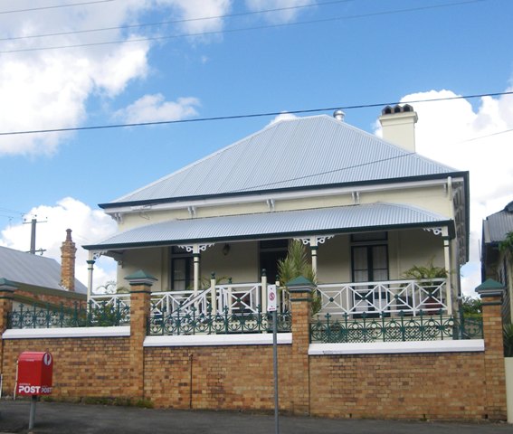

This is an image of the local heritage place known as Residence 'Hamburg Villa'
Hamburg Villa
Addresses
Type of place
House
Period
Victorian 1860-1890
Style
Regency
This single-storey masonry house was probably built by the mid 1880s for Johan (John) Heinrich Ducker, a carpenter, and his family after he acquired the property in 1873. From 1887 to 1890 the house was run as a boarding house and advertised as ‘Hamburg Villa’. The property remained in the Ducker family until 1920.The land originally included the corner site with frontages to Heal (formerly Tamrookum Street) and James Streets. For many years the Ducker family were listed as living at 172 Heal Street which by 1902 contained brick and wooden cottages on the property valued at £486. Johan’s wife died in 1905, and following his death in 1920, the house contents were sold at auction by the public curator. In 1921 the portion of the property containing the house was transferred to Anna Kathrina Barlow, Bertha Kohler and Ernest Kohler, and the portion of land containing the corner store, was transferred to George William Barnard.
Also known as
Merrilands
Lot plan
L1_RP9074
Key dates
Local Heritage Place Since —
Date of Citation —
Construction
Roof: Corrugated iron;Walls: Masonry
Criterion for listing
(A) Historical; (D) Representative; (E) AestheticInteractive mapping
Also known as
Merrilands
Lot plan
L1_RP9074
Key dates
Local Heritage Place Since —
Date of Citation —
Construction
Roof: Corrugated iron;Walls: Masonry
Criterion for listing
(A) Historical; (D) Representative; (E) AestheticInteractive mapping
Description
The painted brick dwelling displays features of the Victorian Regency period, including symmetrical entrance and restrained detailing. The rear of the house has an extensive brick basement.
Statement of significance
Relevant assessment criteria
This is a place of local heritage significance and meets one or more of the local heritage criteria under the Heritage planning scheme policy of the Brisbane City Plan 2014. It is significant because:
References
-
Brisbane City Council Properties on the Web
-
Brisbane City Council, 1946 aerial photographs.
-
Brisbane City Council, Surveyor’s Notebook, 27 April 1912, updated 11 Nov 1924 [in green]
-
Brisbane City Council, Sewerage Maps, Detail Plan No 200, 2 Dec 1924
-
Australian Electoral Rolls, Brisbane Division, Fortitude Valley, J.H. Ducker: 1903; 1905; 1908; 1913 [listed as 172 Heal St]
-
Brisbane City Council, New Farm and Teneriffe Hill Heritage and Character Study, Oct 1995, pg 113
-
Certificates of Title, Department of Environment and Resource Management
-
Queensland Post Office Directory, 1878-79; 1883-84; 1885; 1889; 1902; 1905
-
Australian Death Index, Rebecca Sophie Catherine Ducker, 31 May 1905; Johan Heinrich Ducker 9 July 1920
-
Bennett, H, ‘New Farm from quality street to mixed assortment’, Brisbane Houses, Gardens, Suburbs and Congregations, Papers No 22 Brisbane History Group, 2010 pg 152
-
Schiavo, J. New Farm: A study of land use and settlement to 1999, pg 27
-
Benjamin, G. & Grant, G. Reflections on New Farm, New Farm & Districts Historical Society Inc, New Farm, 2008, pg 27
-
Donald Watson and Judith McKay, Queensland Architects of the Nineteenth Century, South Brisbane: Queensland Museum, 1994
-
Apperly, R. Irving, R. Reynolds R, A Pictorial Guide to Identifying Australian Architecture: Styles and Terms from 1788 to the Present, Angus & Robertson, 1989, pg 46-49
-
Brisbane Courier, 15 Nov 1880, pg 4 [reference to James Street, previously Tamrookum Street]
-
Brisbane Courier, 8 Sept 1881, pg 4
-
Brisbane Courier, 15 Jan 1884, pg 5
-
Brisbane Courier, 8 Sept 1885
-
Brisbane Courier, 28 March 1887, pg 8
-
Brisbane Courier, 1 May 1899, pg 6
-
Brisbane Courier, 28 May 1902, pg 2
-
Brisbane Courier, 9 Aug 1920, pg 12
Citation prepared by — Brisbane City Council (page revised June 2022)