Addresses
Type of place
House
Period
Interwar 1919-1939
Style
Spanish Mission
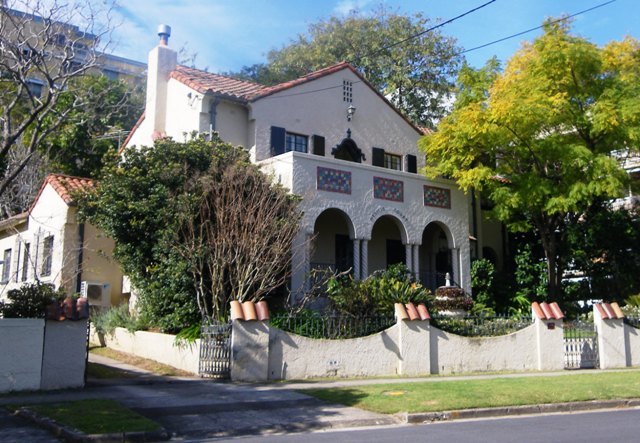

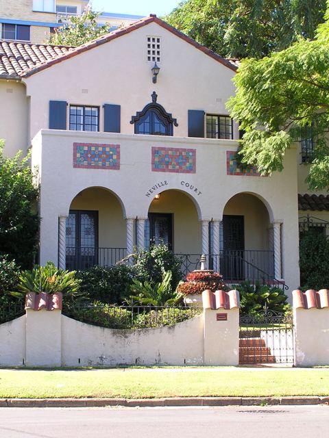
This is an image of the local heritage place known as Residence 'Neville Court'
This is an image of the local heritage place known as Residence 'Neville Court'
Neville Court
Addresses
Type of place
House
Period
Interwar 1919-1939
Style
Spanish Mission
Neville Court was designed in 1936 by prominent interwar architects Chambers and Ford. This Spanish Mission residence with complementary front fence and mature garden contributes to the aesthetics of the local streetscape.
Lot plan
L6_RP41499; L5_RP41498
Key dates
Local Heritage Place Since —
Date of Citation —
Construction
Roof: Terracotta tile;Walls: Masonry - Render
People/associations
Chambers and Ford (Architect)Criterion for listing
(B) Rarity; (D) Representative; (E) Aesthetic; (H) Historical associationInteractive mapping
History
With the closure of the Moreton Bay penal settlement in 1842, Brisbane was opened up for free settlement, however, surveyors had begun subdivision plans for the New Farm area as early as 1839 and large-acreage portions had been auctioned through the 1840s and 1850s. The land around Maxwell Street was part of Eastern Suburban Allotments (ESA) 15, 17 and 18. This land was first alienated from the Crown in 1845 and purchased by John McConnell who owned Cressbrook Homestead in the Brisbane Valley.
Throughout the latter part of the 19th century, New Farm became a popular residential suburb and many large villa estates were created such as James Clarke’s Wybenia and Samuel Griffith’s Merthyr. This early pattern of development differed markedly from nearby Fortitude Valley and Spring Hill where workers’ cottages on small lots predominated. In 1865 McConnell sold over 17 acres, comprising ESA 17 plus part of ESA 16 to John Sargent Turner, who from 1878 until 1900 was a member of the Queensland Legislative Council. A second wave of subdivision occurred in the late nineteenth and early twentieth centuries as parts of the original villa estates were subdivided.
The creation of Maxwell Street occurred late in this process and in three stages. George Raff’s widow Eliza Jane Raff (formerly Molle nee Lord) subdivided part of neighbouring ESA 18 in 1910, the resulting 26 residential allotments offered for sale on site on 16 September 1911 as the “Riverside Slopes” estate. This created the first part of Maxwell Street between Merthyr Road and the end of Raff Lane. The street was originally named Molle Street on the 1911 Estate map, but by 1912 had been renamed Maxwell Street.
Elsie Dodwell, who had purchased ESA 15 and part of ESA 17 in 1916 then carried out subdivisions which extended Maxwell Street to Dodwell Lane in 1925. The final cul-de-sac blocks were subdivisions of ESA 15, completing the current extent of Maxwell Street in 1932. Consistent with New Farm’s reputation as a desirable residential suburb which was close to town and well-serviced by the city’s tram network, Maxwell Street offered residents either riverfront properties on the southwestern side of the street or elevated properties with city views on the north-eastern side. The various Maxwell Street houses, a number of them architect-designed, were built in a relatively short period of time from 1912 to 1946, with the majority being constructed between 1928 and 1937.
It was a notable feature of the inter-War period of residential development in Brisbane that a diverse range of house styles were experimented with – each seeking to express a new, modern, post-World War 1 era. Together with the evolution of the domestic timber vernacular into the multi-gable Queensland Bungalow style, other (particularly masonry) styles with distinctly European influences emerged locally including Spanish Mission, Mediterranean, Mock Tudor (or Old English), Art Deco and the very modern Functionalist style. Maxwell Street, particularly at the northern end, contains a several fine examples of these styles.
In October 1933 Mrs Margaret Scarborough purchased the two subdivisions (totalling 31 perches or 780 m2) on which “Neville Court” now stands. Three years later in November 1936 Mrs Scarborough was granted approval by the Brisbane City Council to construct a brick dwelling valued at ₤2500 funded by a mortgage registered in March 1937. The house was designed by the prominent Brisbane architectural firm of Chambers and Ford and the builder was N. Smith of Redcliffe.
Chambers and Ford was the partnership of Claude William Chambers (1861-1947) with E. M. Ford from 1920 up until the beginning of World War II. Chambers and Ford were responsible for a number of elite houses, apartment buildings, churches and commercial buildings across Brisbane during the inter-war period.
Mrs Scarborough and her husband Thomas (a butcher with shops in George Street, Brisbane and Wickham Street, Fortitude Valley) lived in the house until its sale in 1944. In April 1944 motor dealer Robert Look bought the house. He and his wife Jean held it for 23 years but lived there only briefly until the sale in 1979 to Walter Grech and Peter Baker-Finch, retailer of homewares and furniture.
Description
Neville Court is a two-storey rendered masonry residence constructed in the Spanish Mission style. The heavy, half-round terracotta tiled roof, projecting porch with a short arcade of three arched openings topped by tiled panels, and "barley twist" columns are dominant features of the exterior. Ornamental leadlight French doors lead from the porch to the interior.
The exterior of the house appears to be very intact. The setting contributes to the overall design of the house and includes a low, rendered masonry front wall with halfround terracotta capping and mature Poinciana trees. The name Neville Court is inscribed over the central front arch.
Statement of significance
Relevant assessment criteria
This is a place of local heritage significance and meets one or more of the local heritage criteria under the Heritage planning scheme policy of the Brisbane City Plan 2014. It is significant because:
References
-
Brisbane City Council, Detail Plans (and supporting Surveyors’ Notebooks)
-
Brisbane City Council, Properties on the Web website including Building Records
-
Brisbane City Council, 1946 aerial photographs.
-
Commonwealth Electoral Rolls 1936-1950
-
Department of Natural Resources, Queensland Certificates of Title and Survey Plans Notes obtained from Robert Riddel Architects
-
Queensland Post Office Directories, 1936-1941
-
Watson, Donald and Judith McKay. A Directory of Queensland Architects to 1940. (St. Lucia: U of Q Press, 1984)
Citation prepared by — Brisbane City Council (page revised September 2020)