Addresses
Type of place
Flat building
Period
Late 20th Century 1960-1999
Style
International
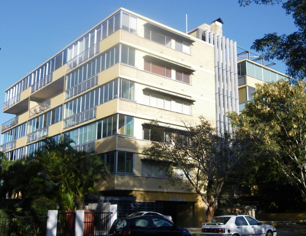

This is an image of the local heritage place known as 'Roseview' flats
Roseview
Addresses
Type of place
Flat building
Period
Late 20th Century 1960-1999
Style
International
‘Roseview’ was built in 1965-66 for Francesco Masinello and Rosa Masinello. This followed a building application in September 1965 for the construction of 25 units at a cost of £80,000. In 1966 the property was transferred to Roseview Pty Ltd, after which the building is named.The building’s horizontality and absence of ornamentation reflects elements of the International style. The biscuit-coloured face bricks and concrete banding on each level is typical of 1960s apartment blocks. The building’s U-shape layout provides access to unit entrances via walkways on each level facing Oxlade Drive. The front of the building faces Brunswick Street and features stonework on either side of the entrance. ‘Roseview’ was built when high-rise residential blocks were beginning to change the housing character of New Farm, exemplified by ‘Glenfalloch’ (1962) and ‘Gleneagles’ (1964) – a postwar extension of the interwar trend in low-rise blocks of flats.
Lot plan
Key dates
Local Heritage Place Since —
Date of Citation —
Construction
Walls: MasonryPeople/associations
Jolly Living Building Co (Builder)Criterion for listing
(A) HistoricalInteractive mapping
Lot plan
Key dates
Local Heritage Place Since —
Date of Citation —
Construction
Walls: MasonryPeople/associations
Jolly Living Building Co (Builder)Criterion for listing
(A) HistoricalInteractive mapping
Statement of significance
Relevant assessment criteria
This is a place of local heritage significance and meets one or more of the local heritage criteria under the Heritage planning scheme policy of the Brisbane City Plan 2014. It is significant because:
Supporting images

Lionel & Douglas Keen (photographers) for the Royal Australian Institute of Architects (Queensland Chapter),
'Roseview' flats, 2 Oxlade Drive, New Farm, looking west, c.1966,
John Oxley Library, State Library of Queensland
References
-
Brisbane City Council Properties on the Web
-
Brisbane City Council Aerial Photographs
-
Brisbane City Council Dept of Water Supply and Sewerage, Sewerage House Construction Section, 15 March 1965, for Roseview Pty Ltd, Brunswick Street, New Farm
-
Brisbane City Council, New Farm and Teneriffe Hill Heritage and Character Study, Oct 1995, pg 46
-
Certificates of Title, Department of Environment and Resource Management
-
Benjamin, G. & Grant, G. Reflections on New Farm, New Farm & Districts Historical Society Inc, New Farm, 2008, pg 4, 125
-
Architecture & Building Journal, Vol 47, pg 37, 18 Aug 1969
-
De Gruchy, G., Architecture in Brisbane, Boolarong Publications, 1988, pg 50-52
-
Apperly, R. Irving, R. Reynolds R, A Pictorial Guide to Identifying Australian Architecture: Styles and Terms from 1788 to the Present, Angus & Robertson, 1989, pg 214-215
Citation prepared by — Brisbane City Council (page revised June 2022)