Addresses
Type of place
Retaining wall
Period
Interwar 1919-1939

This is an image of the local heritage place known as Retaining wall
Retaining wall
Addresses
Type of place
Retaining wall
Period
Interwar 1919-1939
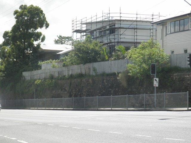
This porphyry stone retaining wall extends from in front of 168 Wynnum Road (Hawthorne) along Wynnum Road to the east and for a short distance into Hawthorne Road. The wall was built by 1934 but probably dates from an earlier period as it supports the embankment created by the cutting for Wynnum Road near this intersection. Porphyry has been used since the early European settlement of Brisbane as a building material for buildings, walls, roadside curbing and other infrastructure. With its distinctive tones of cream, brown, purple and pink, the stone has made a significant contribution to the visual appeal of the city and suburban townscapes of Brisbane.
Geolocation
-27.472581 153.059047
Key dates
Local Heritage Place Since —
Date of Citation —
Construction
Walls: StoneCriterion for listing
(A) Historical; (D) Representative; (E) AestheticInteractive mapping
Geolocation
-27.472581 153.059047
Key dates
Local Heritage Place Since —
Date of Citation —
Construction
Walls: StoneCriterion for listing
(A) Historical; (D) Representative; (E) AestheticInteractive mapping
History
This porphyry retaining wall was built prior to 1934 and supports a steep embankment in front of several houses in Wynnum Road on the boundary between the suburbs of Hawthorne (to the north) and Norman Park. The primary function of retaining walls in Brisbane is usually to facilitate the construction of roadways through the city’s notoriously hilly terrain.
Wynnum Road provided access to the seaside settlement of Wynnum during the nineteenth century. In 1895, this section of Wynnum Road was known as Cemetery Road as it led to the large Balmoral Cemetery. In 1925, the tramline was extended along what is now Wynnum Road from the Norman Creek Bridge to the cemetery.
This particular wall extends along the northern side of Wynnum Road below five houses, commencing in front of 168 Wynnum Road and continuing around 2 Hawthorne Road (alternative address, 180 Wynnum Road) on the corner. The extent of the wall corresponds to a large corner allotment of around one and three quarter acres purchased by Alexander Sutherland in 1879. A portion of this land along the Wynnum Road boundary was subdivided for residential development from 1925 and by the mid-1930s, five houses had been built overlooking the cutting for Wynnum Road.
The use of Brisbane’s porphyry (more correctly referred to as Brisbane Tuff) as a building material has a long history in Brisbane. It was quarried at Kangaroo Point in the 1920s and used to build several early convict era buildings of which only the Windmill in Wickham Terrace and the Commissariat Stores (and its retaining wall) in William Street have survived. Additional porphyry quarries were situated at Spring Hill, Herston, Fortitude Valley and Windsor and the distinctive stone was used to built the General Post Office (1872), St Stephen’s Cathedral (1874) and other significant buildings. Porphyry has also been extensively used in the construction of retaining walls, kerbing and bridge abutments. Other porphyry retaining walls in Brisbane include the All Hallow’s wall in Fortitude Valley and the Petrie Bight retaining wall. Some of Brisbane’s porphyry walls were constructed in the 1930s as relief works to provide work for the unemployed during the depression, for example the retaining wall in Manly in Cambridge Parade. As Brisbane’s suburbs expanded for residential development, Brisbane’s porphyry quarries closed and the use of porphyry as a retaining wall material began to decline.
The Wynnum Road retaining wall provides an example of municipal road supporting infrastructure in Brisbane’s suburbs prior to the 1940s and makes an attractive contribution to the streetscapes of Hawthorne and Wynnum Roads.
Description
This retaining wall extends the length of five houses on the corner of Hawthorne and Wynnum Roads. It is constructed from blocks of porphyry stone laid in a traditional stretcher bond pattern. The wall is capped with another row of porphyry stone laid end to end.
The wall begins in front of the house at 168 Wynnum Road and rises gradually in height to several feet before dropping again at the corner before continuing into Hawthorne Rd.
An entrance to the stairway for the interwar era house at 168 Wynnum Road appears to have been cut into the wall after its construction.
Statement of significance
Relevant assessment criteria
This is a place of local heritage significance and meets one or more of the local heritage criteria under the Heritage planning scheme policy of the Brisbane City Plan 2014. It is significant because:
References
-
Brisbane City Council. Detail Plan no. 872, 1934
-
Brisbane City Council. Conservation Management Study – Retaining Wall and cuttings. Nov 2002
-
Queensland Certificates of Title
-
McKellar's Map of Brisbane and Suburbs. Brisbane: Surveyor-General’s Office, 1895
-
E.V. Robertson. “History in Granite and Sandstone: The Old Building Stones of Brisbane”
-
Paper presented to RHSQ, 23 June 1966
Citation prepared by — Brisbane City Council (page revised September 2020)