Addresses
Type of place
State school
Period
Postwar 1945-1960
Style
Bungalow
Addresses
Type of place
State school
Period
Postwar 1945-1960
Style
Bungalow
The Nudgee Beach School opened in 1947. It replaced a temporary school located in the Nudgee Beach School of Arts (demolished 1970) that had been educating the local children since 1926. The school building had been relocated from Woolooman in 1946 and it was shifted again from the corner of O’Quinn Street and Nudgee Road to its present location. In 1988, Nudgee Beach School closed. In 1989, the building was reutilised by the Queensland Government for educational purposes when it became the Nudgee Beach Wetlands Environmental Centre.
Also known as
Ex-Woolooman State School building
Lot plan
L619_SP126299
Key dates
Local Heritage Place Since —
Date of Citation —
Construction
Roof: Corrugated iron;Walls: Timber
Criterion for listing
(A) Historical; (H) Historical associationInteractive mapping
Also known as
Ex-Woolooman State School building
Lot plan
L619_SP126299
Key dates
Local Heritage Place Since —
Date of Citation —
Construction
Roof: Corrugated iron;Walls: Timber
Criterion for listing
(A) Historical; (H) Historical associationInteractive mapping
History
The area now known as Nudgee Beach was a hunting and fishing spot on the shores of Moreton Bay for the Aboriginal Turrabul people before the arrival of European settlers onto their land. In 1863, Alexander McPherson became took freehold title of this site. The first Catholic Bishop of Queensland James Quinn (appointed 1859) purchased 33 acres of land beside Moreton Bay in 1865. A fervent Irish nationalist, he changed his surname in 1875 to O’Quinn. The Bishop gave the land to the Order of the Sisters of Mercy for an orphanage site. St. Vincent’s Orphanage opened in 1869. The nuns and their wards travelled down to Nudgee Beach for excursions and picnics. It was hoped that a retirement home for elderly nuns would be built beside the beach.
Due to its close proximity to the fruit and wine-producing Nudgee District, Nudgee Beach became popular as a holiday camping ground even though it was on private land. Unofficially, it was called ‘Brisbane’s Super Sands’. On 16 July 1907, the controlling local government authority, the Toombul Shire Council declared a public space, the Nudgee Beach Reserve along the foreshore. One of the first structures on the Reserve was a small shop building that opened as a Kiosk and meeting room in 1915. In 1916, the Catholic Church partitioned the St Vincent’s Orphanage land so that the area closest to the Reserve was subdivided into an estate comprising private blocks of land to be for auctioned.
To retain its links to the Catholic Church, the small housing estate’s main street was named O’Quinn Street to honour the Bishop (died 1881) who had helped establish St Vincent’s Orphanage. Nudgee Beach developed into a small holiday and fishing village, with a number of compact, nineteenth century cottages were relocated from other parts of Brisbane and transported by horse teams or truck onto the blocks that had been sold.
Enough residents had settled at Nudgee Beach that, by 1922, they formed the Nudgee Beach Progress Association (NBPA) in November of that year. As a result, community facilities comprising a beach picnic shelter, a changing rooms shed, a First Aid & Ambulance building and a small Concert Hall were erected by the NBPA along the foreshore. A cricket pitch was also laid by NBPA. The NBPA undertook to have a second road access the Reserve. It was named Fortitude Street. This street and its two adjoining streets (Chaseley and Lima) were named after the three immigrant ships that had brought free settlers to the Moreton Bay settlement in 1849.
In 1926, the Association had the Nudgee Beach School of Arts constructed. It served as the suburb’s first school. The school opened on 1 April 1926 with an enrolment of 18 pupils taught by Miss Cecilia Fanning. Miss Fanning lived in Union Street, Nundah and rode her horse ‘Robin’ to and from Nudgee Beach School each day. She left the school in 1932. The first school committee was formed in 1929. From 1942 to 1945, the School of Arts/School building was requisitioned by the Australian Army as barracks for the searchlight detachment that had an emplacement on the Reserve. Members of the Australian Women’s Army Service (AWAS) that had been formed in mid-1941 occupied the searchlight position. During this time, school was conducted from the Hough Family home in O’Quinn Street. After the war and during 1946, the school returned to the School of Arts building. The Nudgee Beach School of Arts fell into disrepair and was it condemned as unsafe and demolished in 1970.
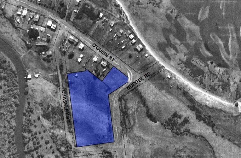
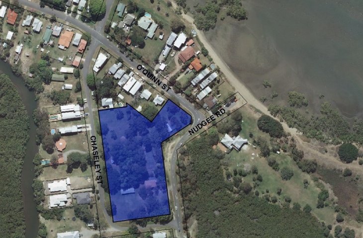
In 1946, the Queensland Education Department purchased four adjoining blocks of land at the corner of O’Quinn Street and Nudgee Road and relocated a school building from Woolooman onto the site. The new Nudgee Beach State School opened on 1 January 1947. It was a clear indicator that Nudgee Beach had developed from a vacation spot to a modern Brisbane suburb. But the site chosen proved to be both swampy and too small for the school’s development. A few years later, a new site was purchased by the state government at the corner Chaseley Street and Nudgee Road. While the land was purchased from St. Vincent’s Orphanage, it was an undeveloped site having been leased by the Fleming Family for grazing purposes until 1943.
The ex-Woolooman School building was once again shifted but just down the road onto the new school grounds. The Nudgee Beach School operated from this location until the end of the 1988 school year. Among the Alumni of Nudgee Beach School are CSIRO scientist John O’Keefe, jockeys Larry Olsen, Sid Fisher and Brian Alvisio and sculptor Len Shillam.
In 1989, the Nudgee Beach School (former) building became the headquarters of the Nudgee Beach Wetlands Environmental Centre run by the state government. The Nudgee Beach Wetlands with its extensive boardwalk trail is an extension of the adjacent Boondall Wetlands. As the Nudgee Beach Wetlands Environmental Centre, the former school building continues in its educational role. Among the visitors are school groups who are given presentations and shown displays in the building, prior to entering the boardwalk.
Statement of significance
Relevant assessment criteria
This is a place of local heritage significance and meets one or more of the local heritage criteria under the Heritage planning scheme policy of the Brisbane City Plan 2014. It is significant because:
References
-
BANGEE Festival Committee, Banyo-Nudgee Heritage Trail, (Brisbane: BANGEE Festival Committee, 2000)
-
Brisbane City Council, aerial photographs 1946 & 2001
-
Brisbane City Council, City Assets Study – Nudgee Beach Reserve, (Brisbane: Brisbane City Council, April, 2002)
-
Brisbane City Council, Heritage Unit citation: St. Vincent’s Orphanage, 131 Queens Rd, Nudgee
-
Department of Natural Resources, Certificates of Title
-
Tremayne, Jean and Pechey, Sue, Pioneers, Picnics and Pineapples, (Brisbane: A.E.B.I.S., 1994)
Citation prepared by — Brisbane City Council (page revised June 2022)

