Addresses
Type of place
Tram / bus shelter, Hall, Sportsground, Park, Reserve, Tree/s
Period
Interwar 1919-1939

This is an image of the local heritage place known as Oriel Park (includes bus shelter Oriel Park bus stop on footpath)
Oriel Park (includes Bus Shelter Oriel Park bus stop on footpath)
Addresses
Type of place
Tram / bus shelter, Hall, Sportsground, Park, Reserve, Tree/s
Period
Interwar 1919-1939
Originally allocated as a water reserve during the 1880s, Oriel Park was gazetted as a recreational reserve in 1937. The park has been well used by the local community, and over the years facilities such as tennis courts, a children’s playground and halls for Guides and Scouts have been incorporated into the site.
Lot plan
Key dates
Local Heritage Place Since —
Date of Citation —
Criterion for listing
(A) Historical; (B) Rarity; (E) Aesthetic; (G) Social; (H) Historical associationInteractive mapping
Lot plan
Key dates
Local Heritage Place Since —
Date of Citation —
Criterion for listing
(A) Historical; (B) Rarity; (E) Aesthetic; (G) Social; (H) Historical associationInteractive mapping
History
As an area of open recreational space since the early 20th century, Oriel Park is important for its association with the early development of the district. As a village green, Oriel Park is important to the local community as a place for gathering and for informal recreation. Distinguished by the row of mature shady fig trees to Alexandra, the park is an important visual element in the streetscape. The park forms a rich shady backdrop to the bus shelter on Alexandra Road. Accommodating the Hamilton Clayfield Girl Guide Group since the early 20th century, the park has an important association with the Girl Guide Association of Queensland.
In 1883 survey plan RP 34386 revealed Oriel Park as a ‘reserve’. By 1888 it was known to the Surveyor General’s Office as a Water Reserve. Council minutes reveal that a waterhole existed in the vicinity of the present playground and was used for road watering purposes in 1912. Oriel Park was gazetted as a recreational reserve in 1937.
Houses were resumed to form the parks present boundaries in March 1959, April 1960 and April 1968. The Girl Guides have had an association with park and their meeting hall since at least July 1951, with the Ascot Boy Scouts War Memorial Hall opened by Alderman Mrs H P White on 23 May 1964, although the Scouts have used the hall for meetings since 1961.
Prior to this time, the site contained open space to Alexandra Road, tennis courts to Wren Street, private residences to the south-west facing Wren Street, including residences to the north-west on to Russell (now Reeve) Street. The park was at the terminus for the local tramline in Alexandra Road until 1969.
Photographic evidence of the 1950s and 1960s shows play equipment (swings, slippery slides, etc) on a large concrete slab area. A time capsule was placed in the park in 1983-84 as a Rotary Club project.
Located in the playground is a static steamroller, possibly a circa 1920 Aveling & Porter model, used to construct roadways. This is now a rare example of what was once a common addition to children playgrounds. During the 1990s many were removed due to safety concerns.
Description
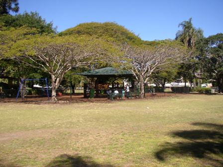
A rectangular block of parkland bounded by Lancaster and Alexandra Roads and Reeve and Wren Streets, Oriel Park forms a village green for the surrounding residential and retail areas. Distinguished by a striking row of shady, mature fig trees to Alexandra Road, the park has open grassed areas and is planted with distinctive mature bunya pines, shade and ornamental trees, palms and a stand of bamboo. To the north east corner, the park accommodates the Hut for the Hamilton Clayfield Girl Guide Group and the former Ascot Boy Scouts War Memorial Hall (now a childcare centre). The park contains a picnic shelter, tables and seating, a toilet block and a fenced playground with play equipment including a steamroller. A path threads across the site from the shops and bus shelter to the east on Alexandra Road to Barlow Street.
The Girl Guide Hut is a single storey freestanding timber pavilion, rectangular in plan and sheltered by a gable roof. The entrance to Reeve Street is marked by a narrow awning supported by decorative timber brackets. The former Scout Hall is a two storey timber and masonry structure unusual for its distinctive lower storey of concrete on a rubble stone base. The lower storey exterior walls are punctuated by regularly spaced unglazed rectangular windows protected by timber shutters.
A timber tram/bus shelter stands to the east of the park on Alexandra Road. Rectangular in plan, the open, freestanding shelter has a hip roof and distinctive austere curved timber brackets to the supporting posts.
Statement of significance
Relevant assessment criteria
This is a place of local heritage significance and meets one or more of the local heritage criteria under the Heritage planning scheme policy of the Brisbane City Plan 2014. It is significant because:
Supporting images
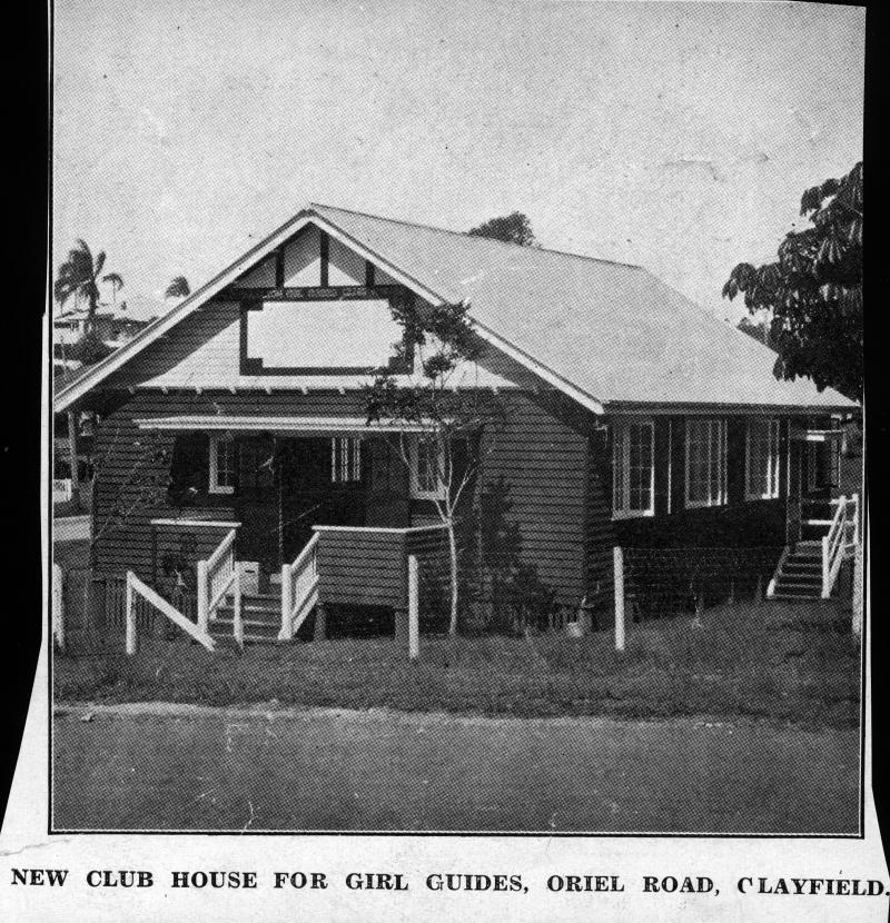
The Queenslander (Brisbane, Qld. : 1866-1939),
‘Girl Guides' hut at Clayfield, Brisbane, 1929',
John Oxley Library, State Library of Queensland
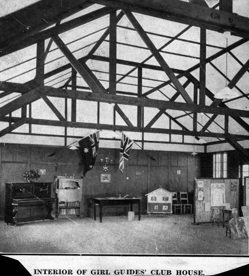
The Queenslander (Brisbane, Qld. : 1866-1939),
‘Interior of the new Girl Guides Club House in Clayfield, Brisbane, 1929',
John Oxley Library, State Library of Queensland
References
-
Oriel Park, Brisbane City Council Conservation Management Plan, 2002
-
Brisbane City Council Surveyor’s Notebook Plans
-
Brisbane City Council Water Supply and Sewerage Detail Plan No 250
-
Brisbane City Council Parks File
Citation prepared by — Brisbane City Council (page revised September 2020)