Addresses
Type of place
Burial ground, Cemetery
Period
Federation 1890-1914
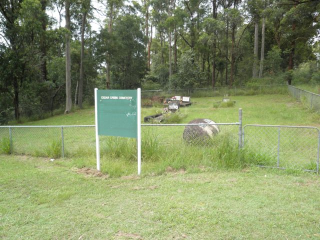

This is an image of the local heritage place known as Cedar Creek Cemetery
Cedar Creek Cemetery
Addresses
Type of place
Burial ground, Cemetery
Period
Federation 1890-1914
As a late 19th century district burial ground, the Cedar Creek Cemetery is important for its association with the early development of the district. As a small bush cemetery in an outlying previously semi-rural area of Brisbane now subject to more intense residential development, Cedar Creek Cemetery demonstrates an endangered aspect of the physical and social fabric of the district. As an early post-European settlement burial ground the site and its records have the potential to yield information about the history of the area. A small cemetery in a formal rectangular grid layout, accommodating austere monuments and standing in a bush setting, the cemetery is an important visual element in the streetscape. As the family burial place for many of the early settlers of the district, Cedar Creek Cemetery is important as a sacred and special place recording and commemorating the lives of those early settlers buried in the cemetery.
Lot plan
L1075_SL5436; L495_SL10068
Key dates
Local Heritage Place Since —
Date of Citation —
Criterion for listing
(A) Historical; (B) Rarity; (C) Scientific; (E) Aesthetic; (G) SocialInteractive mapping
Lot plan
L1075_SL5436; L495_SL10068
Key dates
Local Heritage Place Since —
Date of Citation —
Criterion for listing
(A) Historical; (B) Rarity; (C) Scientific; (E) Aesthetic; (G) SocialInteractive mapping
History
The first Brisbane cemetery was established at North Quay in 1825 during the early days of the penal settlement. This was followed by the establishment of the Paddington Cemetery in 1843 on the site now known as Lang Park. Other early cemeteries were established at Nundah (1846, first records 1887) and Moggill (1855). For the colony of Queensland, the passing of the Cemetery Act of 1865 provided the means to establish general cemeteries under the control of government appointed trustees. Smaller cemeteries were established in Brisbane suburbs including Bald Hills (1869), Bulimba (1869), Brookfield (1872) and Lutwyche (1878). The General Cemetery at Toowong was established in 1875.
The first recorded burial in Cedar Creek Cemetery was that of Alexander Levitt in 1898 and the last was of Thomas Marshall in 1987. A plaque at the cemetery gates records the names of twenty-one people buried in the cemetery.
The Cemetery was restored through the combined efforts of the Ferny Grove and Keperra District Progress Association, The Golden Valley Keperra Lions Club and the descendants of those whose ancestors were pioneers in the district as a bicentennial project in November 1988.
Description
The Cedar Creek Cemetery at Upper Kedron occupies a large rectangular paddock (approximately 19,305m2) bounded by Cemetery Road and Canvey Road to the north and west and residential properties to the south and east. A small cleared and fenced graveyard occupies the northeast corner and the balance of the paddock is unfenced and covered with trees and scrub.
Enclosed by a chain wire fence, the cleared graveyard occupies an area approximately 21m x 24.6m and contains 59 plots. The plots are set out in a grid of 5 rows with varying numbers of plots. Rows B, D and E contain 12 plots each approximately 1.25m x 2.5m. Row C contains 12 plots all 1.25m x 2.5m except for plot 6 at 1.5m x 2.8m and plot 5 at 1m x 1.5m. Row A contains 11 plots, 10 of various widths and at 2.5m long and plot 1 at 1.3m x 2.6m. There is a gap of approximately 0.5m between plots 1 and 2 in this row. The plots are laid facing east.
The fenced graveyard contains seven burial sites with identifying monuments and one site with unidentified remnants grouped together across two plots. One grave also has the fragments of another headstone lying on its table.
The unidentified remnants of a grave lie in the middle of the large unfenced portion of the paddock.
A plaque fixed to a large rock inside the cemetery gate contains a list of twenty-one people buried in the cemetery. Of these ten have identifiable graves.
plot occupant age year buried
A4 Alexander Levitt 62 yrs 1898
A2 Arthur Ernest Marshall 1 2 yrs 1910
C1 Ivy Merle Pickering 15 months 1934
Valma Doris Pickering 3 weeks 1937
C4 Raymond Thomas Marshall 12 yrs 1947
C5 Esme Joan Marshall 2 yrs 1931
C6 Harry Marshall 28 yrs 1927
D5 & Sarah Ann Marshall 73 yrs 1945
D6 Thomas Marshall 85 yrs 1945
Thomas Marshall 76 yrs 1987
The fractured marble headstone for the grave of Kendal L. Boreham (died 1906, aged 3 years) lies on the table of the Pickering grave plot C1.
The cemetery monuments are austere, generally consisting of concrete tables with vertical marble headstones or marble tablets fixed to concrete headstones. The grave for Harry Marshall is distinguished by its polished pink granite headstone and enclosing decorative iron fence. The grave for Alexander Levitt has a marble headstone lying on the grave table lettering now obscured and a recent polished plaque fixed onto the table surface. Plaques for the monumental masonry firm of P.J. Lowther & Son are fixed to a number of the grave monuments.
Fragments, including four low concrete bollards and two bases for headstones, are arranged across plots C8 and C9.
Floral tributes stand on some of the graves.
The monuments located in the fenced portion of the Cemetery show signs of weathering generally. A number of headstones are broken or fractured. The headstone for Kendal Boreham lies in fragments on the table of the Pickering grave. The headstone for Esme Marshall is broken and fragments lie on the grave. The lettering on the marble headstone lying on the Alexander Levitt grave is badly worn and parts are lost.
The remnants of a grave lie to the centre of the bush covered paddock. This site is hidden from the road and not easily found. The site should not be disturbed until further research is undertaken to determine its identity.
It is important that an appropriate repair, cleaning and maintenance programme be established for the Cemetery.
The Cemetery, particularly the bush covered paddock portion, is vulnerable to the intrusions of expanding suburbanism. The surrounding once semi-rural suburb of Brisbane is now undergoing intense residential development. Surrounding land that was once covered with bush or used for farming is now occupied by residential properties.
Statement of significance
Relevant assessment criteria
This is a place of local heritage significance and meets one or more of the local heritage criteria under the Heritage planning scheme policy of the Brisbane City Plan 2014. It is significant because:
References
-
Brisbane City Council - City Assets Branch Conservation Management Study Stage 1 Report. November 2002
Citation prepared by — Brisbane City Council (page revised September 2020)