Addresses
Type of place
Roadway, Urban precinct
Period
Victorian 1860-1890
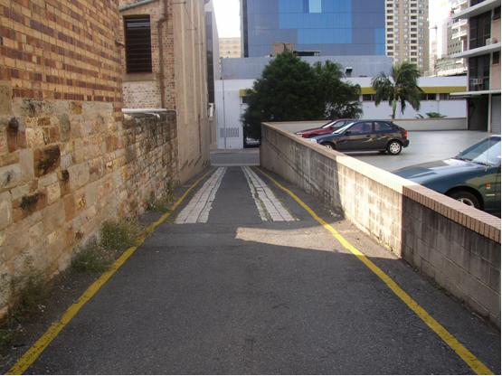

This is an image of the local heritage place known as Beatrice Lane
Beatrice Lane
Addresses
Type of place
Roadway, Urban precinct
Period
Victorian 1860-1890
This lane was built circa 1887 to service the buildings that occupied this section of Margaret Street and by 1895 had also been extended to Albert Street. Porphyry (Brisbane tuff) stonework was laid in two rows to provide a carriageway for the wagons and drays that used the lane, and was most likely added around 1895. The lane was originally known only as an unnamed side lane but was given the name ‘Beatrice Lane’ circa 1989.
Lot plan
L9_SP142332; L11_RP1073
Key dates
Local Heritage Place Since —
Date of Citation —
Criterion for listing
(A) Historical; (B) RarityInteractive mapping
Lot plan
L9_SP142332; L11_RP1073
Key dates
Local Heritage Place Since —
Date of Citation —
Criterion for listing
(A) Historical; (B) RarityInteractive mapping
History
This service lane was built, in the late nineteenth century, to provide access to the workshops and stables at the rear of buildings that occupied this section of Margaret Street. This part of the CBD, bounded by George, Edward, Elizabeth and Alice Streets, was known colloquially as ‘Frogs Hollow’ because it was low-lying, swampy ground. It also possessed a dubious reputation due to the presence of brothels and opium dens. However, given its proximity to the expanding wharf facilities located on the Town Reach of the river, the area rapidly developed as a warehouse and light industry precinct from the 1880s onward. The expansion of the business also reflected the economic boom of the 1880s. The population of Brisbane almost tripled in this decade, which no doubt contributed to an increased demand in the goods and services offered by the many business that had access to Beatrice Lane.
It became one of a large number of public and private lanes that allowed tradesmen and horse-drawn delivery vehicles to gain access to the loading docks and other facilities located at the rear of many CBD buildings. Such lanes were common within Brisbane’s growing commercial precincts, particularly within the CBD, South Brisbane and Fortitude Valley. But most of the lanes that had serviced South Brisbane’s commercial centre were lost to the redevelopment of the area that occurred in preparation for World Expo’88.
The Margaret Street service lane was then further extended, at a right angle, to Albert Street by 1895. The porphyry carriageway was most likely laid at this time. The porphyry (Brisbane tuff) stonework was laid in two rows to provide a carriageway for the wagons and drays that serviced these buildings. The porphyry would have ensured horse-drawn carts did not become bogged down in the dirt lane, which would have been a muddy slope during periods of heavy rain.
During the twentieth century, with the increasing congestion on the CBD’s streets caused by motor cars, trucks, trams and buses, these lanes also became a quick and popular way for city workers to cross from one City block to another, thereby avoiding both road traffic and City crowds.
This lane appears to have been given the name of ‘Beatrice Lane’ circa 1989. Around the same time, the CBD’s service lanes were given a more formal recognition as part of the streetscape of the CBD. Thus apart from the allocation of names for the purposes of identification, the Brisbane City Council erected street signage to mark the entrance to each lane and they were marked as such on the various street Brisbane directories that were published later. Other examples are Stereo Lane and Esk Lane.
From the late 1980s onwards, many of the CBD’s lanes were lost or reduced in size to make way for redevelopment of those parts of the CBD that they serviced. The clearing of the Roma Street Markets precinct (later to become the site of the new Magistrates Court) saw the demise of Little Roma Street. Parbury Lane was lost to the Brisbane Riverside Markets and Riparain Plaza redevelopment. Patrick Lane went with the construction of Admiralty Towers beside the Brisbane River. Old Burnett Lane disappeared when the Criterion Hotel was redeveloped as a high-rise building. Alvis Lane, running off Charlotte Street was also lost to high-rise redevelopment. The unnamed lane running between Queen and Elizabeth Streets was resumed for the Myer Centre. The L-shaped service lane running off Queen Street in the block between George Street and North Quay, and the T-shaped lane running off Turbot Street in the block between George Street and North Quay have also been lost. Stereo Lane is soon to disappear as part of a high-rise development fronting Elizabeth Street.
Isle Lane was halved in size and ceased being a thoroughfare between Adelaide and Queen Streets when Post Office Square and its underground car park were built. Rich Lane has also been reduced in size due to surrounding development. Both the remnants of Raff and Bowen Streets that ran off Adelaide Street were incorporated into Cathedral Square. Of the remaining 14 public and private lanes located across the CBD, only six are similar to Beatrice Lane, in that they still provide two-street access.
The Beatrice Lane Carriageway demonstrates the development of this part of the Central Business District (CBD) as a warehouse and light industry precinct in the nineteenth and twentieth centuries. Beatrice Lane remains the only Central Business District laneway with exposed porphyry stonework, thereby serving as an illustration of the fabric of the many service lanes that used to run throughout the CBD. All other CBD lanes have had their porphyry base (if it existed) covered over with tar, bitumen or concrete. Beatrice Lane is one of the few surviving service routes left from many lanes that were once an important part of the streetscape of Brisbane’s commercial centre. It is also the only remaining private service lane that acts as vehicular thoroughfare and connection between two CBD streets.
Description
Beatrice Lane is an L-shaped laneway connecting Margaret Street to Albert Street. The majority of the lane is covered with bitumen and a porphyry carriageway extends along two-thirds of the lane from Margaret Street. The lane, as it extends from Margaret Street, is bounded on one side by a car park for the ‘Camelot Court’ apartment complex and on the other by the state-heritage listed Watson Brothers Building. A porphyry wall demarcates the yard and former workshop and stables at the rear of the Watson Brothers Building from the lane.
Statement of significance
Relevant assessment criteria
This is a place of local heritage significance and meets one or more of the local heritage criteria under the Heritage planning scheme policy of the Brisbane City Plan 2014. It is significant because:
References
-
Brisbane City Council Aerial Photos 1946, 2001, 2005
-
Brisbane City Council, Sewerage Map 1913
-
Brisbane City Council, City Plan Heritage Register citation – Fish Lane, South Brisbane, (Brisbane: Brisbane City Council Heritage Unit, 2002)
-
Cole, John R. Shaping a City: Greater Brisbane 1925-1985. Brisbane: William Brooks Queensland. 1984
-
John Oxley Library, photographic collection.
-
Mahlstedt & Son, City of Brisbane Detail Fire Survey Maps, 1951
-
Queensland Post Office Directories, 1868-1949
-
UBD, 2006 Brisbane Street Directory 50th edition, (Brisbane: Universal Press, 2006)
-
UBD, Refidex Street Directory of Brisbane 30th edition, (Brisbane: Universal Press, 1986)
Citation prepared by — Brisbane City Council (page revised September 2020)