Addresses
Type of place
Farm house, Farm
Period
Federation 1890-1914
Style
Queenslander


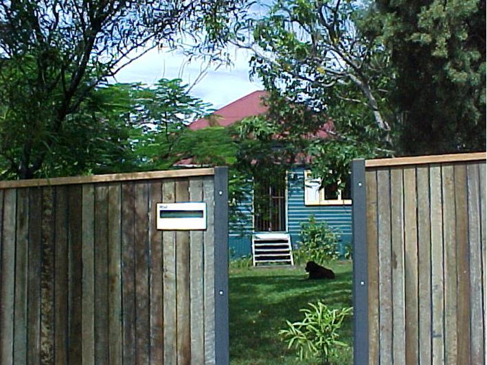
This is an image of the local heritage place known as H.W. Robinson Farmhouse
This is an image of the local heritage place known as H.W. Robinson Farmhouse
H.W. Robinson Farmhouse
Addresses
Type of place
Farm house, Farm
Period
Federation 1890-1914
Style
Queenslander
Constructed circa 1891, this timber and tin residence is one of the few remaining examples of a farmhouse built in the Aspley District (then known as Cabbage Tree Creek) during the nineteenth century. It was constructed for Henry Walter Robinson, whose family who were prominent district pioneers. As the Robinson family grew, their large pineapple farm was subdivided into smaller family farms and H.W. Robinson obtained one of these farms.
Lot plan
L16_RP86224
Key dates
Local Heritage Place Since —
Date of Citation —
Construction
Roof: Corrugated iron;Walls: Timber
People/associations
Robinson family (Occupant)Criterion for listing
(A) Historical; (B) Rarity; (H) Historical associationInteractive mapping
Lot plan
L16_RP86224
Key dates
Local Heritage Place Since —
Date of Citation —
Construction
Roof: Corrugated iron;Walls: Timber
People/associations
Robinson family (Occupant)Criterion for listing
(A) Historical; (B) Rarity; (H) Historical associationInteractive mapping
History
The land on which this building sits was originally a twenty-acre portion of crown land first purchased, on 4 March 1867, by John Warner, of Brisbane. The deed of grant was issued to land speculator, John Warner, for £20. Portion 399 was part of a large land purchase made by Warner at this time, as he also bought the adjoining twenty-acre Portions 338, 400, 401, 402 and 406. Thus Warner controlled 120 acres of land situated between what are now, Robinson Road West and Ellison Road.
Portion 399 was transferred to John Cameron, of Brisbane, on 15 June 1869. On 4 December of that same year, Cameron passed the title deed to William John Robinson. In the title deed pertaining to that transfer, William Robinson was noted as a ‘minor aged 12 years’. William Robinson was the son of Thomas and Elizabeth Robinson of Gympie. This land was purchased the year following Thomas Robinson’s death and it is likely that the funds to purchase it for young William were derived from his father’s estate. The description of Portion 399, as supplied on the title deed, included a mention of a boundary road, one chain wide and this would eventually become the road that bears the Robinson family’s name. Robinson’s land was situated east of Cabbage Tree Creek, in an area known as Zillmere.
A mortgage for £2,000 was taken out over the property on 15 July 1885, when William Robinson was 28 years old. William Campbell Whitehall, William Tracey Bennett and a widow, Mary Eliza Taylor, financed the mortgage. Robinson took out two subsequent mortgages. The Royal Bank of Queensland Limited lent him 300 on 17 April 1889; while a further 250 was obtained from Thomas Rees Edward Grisnlod and Peter Thinule on 5 September 1889. Both mortgages had been repaid by 1891. The Queensland Post Office Directories did not record William Robinson to be in receipt of mail at Aspley or Zillmere during the period 1869-1891. This would suggest that the mortgages were not used to construct the house at 500 Robinson Road West during the period of his ownership of the land. It is probable that William Robinson used the mortgages for business purposes.
Henry Walton Robinson, of Kedron, purchased Portion 399 on 20 May 1891, taking out a mortgage for £450 at 8% pa repayable quarterly. David Ferdinand Longland provided the money for this mortgage. After Longland died, on 11 September 1896, the mortgage transferred to the ownership of George Longland, George Edwin Marshall and Charlotte Anne Longland. Henry W. Robinson is listed as residing at Zillmere for the first time in the 1892 Queensland Post Office Directory. Thus it is likely that the mortgage, Henry Robinson secured in May 1891, was used to pay for the construction of his farmhouse at 500 Robinson Road West. Henry Robinson’s farmhouse had been completed by 1892.
It was one of a number of farmhouses that were built along Robinson Road for small-scale farmers and primary producers in the closing decade of the nineteenth century. By the commencement of the 1890s the large landholdings in the Aspley area were beginning to be subdivided and sold off for small farm use such as dairies, vineyards, fruit orchards or piggeries. The impetus for this change in land usage in the Aspley and Zillmere districts had been the opening of the J.C. Hutton smallgoods factory at Zillmere in 1888. In the case of Portion 399, Henry Robinson made his farm into a pineapple plantation.
Samuel Francis Mison obtained Portion 399 and its farmhouse in 1905. In 1912, Mison bought the adjacent land on subdivision 2 of Portion 400, including the cottage at 544 Robinson Road West. The Queensland Post Office Directories did not list Mison as living in the Zillmere district until 1921-22. At that time his occupation was listed as a factory manager and it is likely that he was employed at J.C. Hutton's smallgoods factory as this was the only factory anywhere near Robinson Road. In 1932, Mison subdivided his 20 acres and he transferred the two roods of subdivision 1 to Ledas Alfred Mison on 24 May. This land was where the house at 492 Robinson Road West was erected. A new title deed for subdivision 2 of Portion 399 was issued to Mison on 13 February 1939. When Mison died on 26 November 1940, his estate passed to his widow, Mary Annie Mison. The 1946 aerial photographs show the farmhouse at 500 Robinson Road West. Cultivated fields surround it, with two large farm sheds sited down the slope at the back of the house.
The lifting, in the 1950’s, of the area’s status as part of Brisbane’s ‘green belt’ had ushered in a period of rapid urbanisation. From this time, the Aspley and Zillmere districts began a third phase of development with the small farms being further subdivided and converted into suburban housing estates. To provide infrastructure for these new housing estates, government agencies resumed some farmland for road and other purposes. Thus Mary Mison lost more than 2 roods of land, resumed by the Brisbane City Council for electricity purposes, on 23 April 1953. Then in 1957, Mary Mison undertook a major subdivision of her property by converting it into 62 suburban house blocks and thus bringing to an end the site’s use a farm. On 25 February 1957, she transferred sixty-one of these subdivisions to a developer, A.F. Grant Pty Ltd. Mary retained resubdivision 16, which was the block containing the farmhouse. After Mary Mison’s death on 4 May 1957, her estate passed to Wallace Lampton Mison and Roy Evans.
During the 1960s, minor development occurred to the place, including an extension at the rear of the farmhouse, and the installation of a garage. A swimming pool was installed in the 1970s. The place remains in private ownership.
Description
This cottage, sited along Robinson Road, is built in timber with timber board external walls and a corrugated iron roof. The house has a short-ridge pyramid roof and a separate lower curved verandah roof to the front in a fashion common to 19th century dwellings.
The house is set on low stumps with the front steps centred to the front verandah directly onto the front door. The front verandah, enclosed at a later time with horizontal boards, has a window opening at either side of the main entry.
At the front boundary a high timber-paling fence separates the house from the street. The front garden is shaded with several trees that add to the character of the house in its street setting along Robinson Road.
Statement of significance
Relevant assessment criteria
This is a place of local heritage significance and meets one or more of the local heritage criteria under the Heritage planning scheme policy of the Brisbane City Plan 2014. It is significant because:
References
-
Brisbane City Council, Properties on the Web, website
-
Brisbane City Council, 1946 aerial photographs.
-
Brisbane City Council’s Central Library, Local History files – Zillmere – Geebung – Aspley – Bald Hills.
-
Department of Natural Resources, Queensland Certificates of title and other records.
-
John Oxley Library, Parish of Nundah, County of Stanley, L.A.D. of Brisbane map, (1899 land grant map).
-
Queensland Government, Queensland Pioneers Index 1829-1889, (Brisbane: Department of Justice and Attorney General, 2000)
-
Queensland Post Office Directories, 1868-1949
-
Teague, D.R., The History of Aspley, (Brisbane: Colonial Press, 1972).
-
Teague, David, The History of Chermside, (Brisbane: Colonial Press, 1973)
Citation prepared by — Brisbane City Council (page revised March 2025)