Addresses
Type of place
Farm house, Farm
Period
Federation 1890-1914
Style
Queenslander
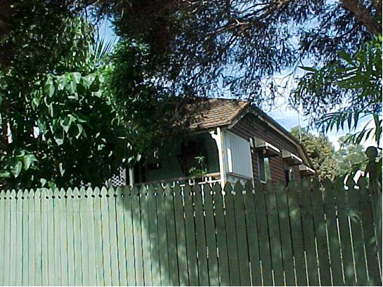

This is an image of the local heritage place known as Farmhouse 'Braeside'
Braeside
Addresses
Type of place
Farm house, Farm
Period
Federation 1890-1914
Style
Queenslander
This is one of the few remaining examples of a farmhouse built in the Aspley District (then known as Cabbage Tree Creek) during the nineteenth century. It was built circa 1895 for farmer and ham scaler James Bruce, who also undertook seasonal work at the local J.C. Hutton’s ham & bacon factory (opened 1888). The Bruce family retained ownership of their home for 90 years. This residence is representative of the Aspley District’s second period of development when large land holdings were converted to small fruit or pig farms, which then serviced the Hutton’s factory.
Lot plan
L2_SP164585; L1_SP164585
Key dates
Local Heritage Place Since —
Date of Citation —
Construction
Roof: Tile;Walls: Timber
Criterion for listing
(A) Historical; (H) Historical associationInteractive mapping
Lot plan
L2_SP164585; L1_SP164585
Key dates
Local Heritage Place Since —
Date of Citation —
Construction
Roof: Tile;Walls: Timber
Criterion for listing
(A) Historical; (H) Historical associationInteractive mapping
History
This property was part of a purchase of crown land made by William Kirby, of Brisbane on 23 January 1867. Kirby paid £15 for 15 acres of land that was designated Portion 425 in the Parish of Kedron. On the same day Kirby bought Portions 422, 423, 426 and 427, which were the similar size and price as Portion 425. He added further to his land holdings when he bought another 15 acres in Portion 424 on 9 February 1867. This gave Kirby control of nearly 90 acres of land in an area bounded by what are now Robinson, Kirby and Ellison Roads. This made Kirby a major landholder in the Zillmere district, which, was an area that would be defined as any land to the east of Cabbage Tree Creek. Kirby’s substantial land ownership is the reason why Kirby Road is named after him.
Just over a year after buying the land, on 29 May 1868, Kirby had transferred all of his land holdings to his wife, Emma Kirby. William Kirby was a farmer and he built his farmhouse on Portion 427 along what is now Ellison Road sometime around 1885.
The opening of the J.C. Hutton Cannery at Zillmere in 1888 brought major changes to the Aspley and Zillmere districts. From the 1890s, the original large land holdings began to be subdivided into small farming allotments. These farms were to be run as piggeries, dairies or orchards that would provide produce to Hutton’s factory. Thus on 14 June 1892, Emma Kirby secured a mortgage for £350, through Charles Willis, in order to finance the subdivision her husband’s original land grant into smaller allotments. On 7 January 1895, the mortgage was transferred to the control of the Brisbane financier, Aaron Adsett.
On 26 April 1897, the first of Kirby’s small farm allotments, that is subdivision 1 of Portion 425, had been transferred to Ellen Bruce, the wife of James Bruce. James Bruce was a farmer who supplemented his income by working as a ham scaler at Huttons. Bruce’s farm occupied 5 acres at the eastern corner of Kirby Road and Robinson Road West. The Queensland Post Office Directories show that Henry Bruce appears as a resident at Zillmere, for the first time in the 1894-1895 edition. As the Memorandum of Conveyance for Ellen Bruce’s acquisition of subdivision 1 of Portion 425, is dated 19 October 1896, then the Bruces must have been living on their farm prior to their acquiring title to the property. It is probable that, the Bruces leased their small farm for a year or two before they gained ownership of the land.
Henry Bruce’s entry in the 1894-95 edition of the Queensland Post Office Directories would indicate that there was a residence to which the Bruces could have their mail delivered. Thus it is assumed that the farmhouse at 640 Robinson Road West was built around 1895 for Bruce. The nameplate of the house still bears the name probably given to it by James Bruce. ‘Bruce’ is a Scottish name and ‘Braeside’ is Scottish meaning beside the road (brae).
James Bruce further subdivided his small farm on 29 October 1919, when 2 acres and 2 roods were transferred to his son, James William Bruce. This transfer included the land on which the family farmhouse stood. J.W. Bruce continued to operate the family’s small farm until 1970. He received Brisbane City Council approval to add a garage, costing $400, to the property, on 25 August 1970.
By the 1970s, the Aspley district had changed dramatically, from small farms with their scattered wooden farmhouses, into vast suburban brick housing estates. The lifting, in the 1950’s, of the area’s status as part of Brisbane’s ‘green belt’ had ushered in a period of rapid urbanisation. The remaining small farms were not economically viable and their owners were under pressure to sell up to land developers. The Bruce family was also involved in this development activity. On 17 July 1970, the Bruce farm was subdivided into eight residential blocks in preparation for a public land sale. From the 3 November 1970 through to the 1 June 1971, seven of these housing blocks were sold. The Bruce family retained Lot 2, which was the largest block that included the Bruce farmhouse. A new title for these 5418 square metres of land was issued to Gwendolen Bruce and Kenneth George Bruce on 25 June 1976.
The Bruce family subdivided their remaining land on 31 October 1985. It was split into seven house blocks that included two easements. The Brisbane City Council resumed Lot 7 on that day and the remaining lots were disposed of privately. Lot 2, comprising 1196 square metres of land, included the Bruce farmhouse. The farmhouse at 640 Robinson Road West passed from the ownership of the Bruce family in 1986, when the property was transferred to Jeanette and Graham Sykes.
Description
This residence sited along Robinson Rd is a timber construction, with a front verandah and timber boards wall cladding. The farmhouse’s original tin roof was later replaced by tiling. A closer look would be necessary to ascertain the exact material used for this later cladding.
The farmhouse is set on stumps and has a pyramid roof that extends over the verandah. The front verandah is supported by square timber posts with simple timber brackets and has dowel balustrading. Sunhoods protect the side windows.
The mature trees, overgrown garden and high picket fence, which contribute to the prominence of the site in the streetscape, also partially conceal the view of the house from the street.
Statement of significance
Relevant assessment criteria
This is a place of local heritage significance and meets one or more of the local heritage criteria under the Heritage planning scheme policy of the Brisbane City Plan 2014. It is significant because:
References
-
Brisbane City Council, Properties on the Web, website
-
Brisbane City Council, 1946 aerial photographs.
-
Brisbane City Council’s Central Library, Local History files – Zillmere – Geebung – Aspley – Bald Hills.
-
Department of Natural Resources, Queensland Certificates of title and other records.
-
John Oxley Library, Parish of Nundah, County of Stanley, L.A.D. of Brisbane map, (1899 land grant map).
-
Queensland Government, Queensland Pioneers Index 1829-1889, (Brisbane: Department of Justice and Attorney General, 2000)
-
Queensland Post Office Directories, 1868-1949
-
Teague, D.R., The History of Aspley, (Brisbane: Colonial Press, 1972).
-
Teague, David, The History of Chermside, (Brisbane: Colonial Press, 1973)
Citation prepared by — Brisbane City Council (page revised September 2020)