Addresses
Type of place
Flat building
Period
Interwar 1919-1939
Style
Arts and Crafts
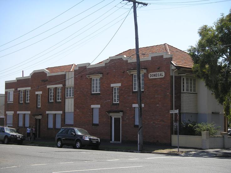

This is an image of the local heritage place known as Set of Flats 'Donegal'
Donegal
Addresses
Type of place
Flat building
Period
Interwar 1919-1939
Style
Arts and Crafts
‘Donegal’ is a set of intact interwar brick flats situated on the corner of St Pauls Terrace and Baxter Street. The building is demonstrative of an increase in the construction of multi-dwelling residences in the 1930s in Brisbane. Donegal was built at a time when some Brisbane residents were choosing to lead, what seemed then, to be a ‘modern’ way of life, apart from the traditional ownership of a house and yard. Donegal is rare as an intact example of brick interwar flats in Fortitude Valley.
Lot plan
L1_RP9723; L4_RP9723
Key dates
Local Heritage Place Since —
Date of Citation —
Construction
Roof: Terracotta tile;Walls: Face brick
People/associations
Clifford Ernest Plant (Architect)Criterion for listing
(A) Historical; (B) Rarity; (E) AestheticInteractive mapping
Lot plan
L1_RP9723; L4_RP9723
Key dates
Local Heritage Place Since —
Date of Citation —
Construction
Roof: Terracotta tile;Walls: Face brick
People/associations
Clifford Ernest Plant (Architect)Criterion for listing
(A) Historical; (B) Rarity; (E) AestheticInteractive mapping
History
The First sale of land in Fortitude Valley occurred in 1844. Nine suburban allotments of two and four acres each were offered at an upset price of £3 per acre. However the land at Kangaroo Point and in the centre of the settlement at north Brisbane was more sought after and when in 1846 the town limits of Brisbane were proclaimed, Fortitude Valley fell outside the limit.
By 1854 there were about 150 dwellings in the Fortitude Valley area, stretching as far as Breakfast Creek. In 1858 Wickham Street was surveyed from the corner of Ann Street to Boundary Street. At this stage very few commercial premises had been erected, and Valley residents relied on North Brisbane traders for supplies. Despite these difficulties the population was steadily growing. A government census in 1861 showed that there was a total population of over 1300 people in Fortitude Valley by that year.
Accompanied by the widespread economic boom of the 1880s were population and building booms. Between 1881 and 1891, Brisbane’s population increased from 37 000 to 100 000. More than half the increase in metropolitan population during the period 1881-1886 was concentrated in Fortitude Valley, Spring Hill, Newstead and South Brisbane.
The densely packed houses of working men and women were predominant in the Valley. To cater for the influx of working class families, new housing was built on tiny allotments in narrow streets, where speculators had divided estates into the maximum possible number of blocks of land. Tiny cottages sprang up in the streets beyond the Valley’s commercial centre. It was this type of subdivision which prompted the government in 1885 to pass the Undue Subdivision of Land Prevention Act which prohibited the subdivision of allotments smaller than 16 perches.
Within a very short time span the residential nature of the Valley began to be eroded. As the 1890s progressed those residential sections in close proximity to the rapidly growing retail and industrial areas were changing. The Valley became a heterogeneous area, and it was not uncommon for houses to have motor garages, factories, churches and even hotels as neighbours.
The residential nature of the Valley further shifted through the 1910s and 20s. As public transport to the middle suburbs improved, families began moving away from the crowded inner suburbs. Many homes in the Valley heart that had once housed single families were converted to boarding houses, a use that continued for most of the century.
As the Great Depression progressed in the late 1920s and into the 1930s a marked deficit of housing in Brisbane emerged. This was the period in which the multi-unit dwelling began to emerge as an alternative to the traditional Brisbane house and yard. Prior to this in larger Australian cities such as Sydney and Melbourne this style of ‘modern’ living, in blocks of flats, had become a stylish alternative to living in the traditional house.
In the early 1930s to cater for the housing shortage as well as to generate income many home owners in the inner-city suburbs converted houses into tenements, where tenants would share bathrooms, toilets and kitchens. This led to community concerns of overcrowding and increased hygiene problems. A fashionable and more sophisticated alternative to this form of accommodation was the purpose built block of self-contained flats. Marketed mainly at single people and childless couples the earliest self-contained flats in Brisbane were generally conveniently situated close to trams, trains and shopping facilities in inner-city suburbs such as Spring Hill, New Farm and Fortitude Valley.
The Brisbane City Council, in 1930, defined the flat as “a fully self-contained dwelling, with private kitchen, bathroom and water closet”. The flat was designed to be an independently functioning dwelling. Although seen as a sophisticated lifestyle, flat living was fairly uncommon in Brisbane in this period, with only 8.4% of Brisbane residents living in flats. This low percentage may be due to the economic constraints of the time as well as the perceived novelty of this style of living. Most interwar flats in Brisbane were architecturally designed and constructed from good quality brick and timber.
In 1933 A. E. Raleigh built a set of brick flats on the corner of St. Pauls Terrace and Baxter Street and named them ‘Donegal’. The preferred location for the construction of flats was a corner block as it allowed greater access to light and ventilation for each flat. Raleigh also owned another set of flats on St. Pauls Terrace in Spring Hill named ‘Clyde Villa’. Donegal was a brick and timber building and was designed by respected Brisbane architect C. E. Plant and built by C. G. A. Day. Donegal was constructed with two wings, an east and a west. The East wing made up of two storeys had smaller flats that shared central bathroom and toilet facilities. The west wing had slightly larger flats on both storeys that were fully self-contained. In 1936 additions were made to extend the apartments, these extensions were also designed by Plant and built by Day.
Donegal is a rare surviving example of a set of intact interwar brick flats built in this part of Fortitude Valley. They reflect the increase in multi-dwelling accommodation in the inner-city suburbs of Brisbane in the 1930s.
Description
‘Donegal’ is a set of interwar brick flats situated on the corner of St. Pauls Terrace and Baxter Street. The building is demonstrative of an increase in the construction of mutli-dwelling residences in the 1930s in Brisbane.
The building was originally constructed with two wings, an east and a west, with a covered footpath dividing the two that led from the Baxter Street entrance to the rear yard. Externally the building is constructed of dark brick with several sets of original casement windows with rendered lintels on the ground and first floors. A decorative rendered brick parapet capping outlines the Baxter Street façade. The building consists of two terracotta tiled hipped roofs joining over the central walkway.
The eastern wing of the building consists of two floors with four separate flats on each floor. An original central bathroom and toilet block is situated on both floors; indicative of the higher density living that was increasingly becoming popular in the 1930s. The two first floor rooms closest to St Pauls Terrace each have an original casement bay window with external shingles as a design feature. Internal features include original silky oak central staircase, timber fanlights above the majority of the original timber doors, silky oak dado rails throughout the flats, and several Bakelite light switches.
The western wing consists of two floors with four separate flats on each floor; these flats are slightly larger than those in the eastern wing. These flats are self-contained with separate bathroom and kitchen facilities. Internal features include original silky oak central staircase, timber fanlights above the majority of the original timber doors, silky oak dado rails throughout the flats, and several Bakelite light switches.
Although there have been several small additions to the building, for example cladding of the entrance of the central covered footpath between the two wings, these are reversible. Donegal is rare as it retains its original external and internal integrity.
Statement of significance
Relevant assessment criteria
This is a place of local heritage significance and meets one or more of the local heritage criteria under the Heritage planning scheme policy of the Brisbane City Plan 2014. It is significant because:
References
-
Bennett, Helen, “Being Modern: Living in Flats in Interwar Brisbane”, Queensland Review, v.13, no.2, 2006, p35-48
-
Department of Environment and Resource Management, “Julius Street Flats New Farm”, Heritage Citation
-
Brisbane City Council Building Registers
-
Certificates of Title, Department of Natural Resources and Water
-
Greenwood, Gordon and John Laverty, Brisbane 1859-1959: A History of Local Government, The Council of the City of Brisbane, Brisbane, 1959
-
Mahlstedt & Son, City of Brisbane Detail Fire Survey, Map No. 30, 1951
-
Metropolitan Water and Sewerage Board Survey Maps, Detail Plan No. 151, 1914
-
Queensland Post Office Directories, 1868-1949
-
Watson, Donald & Judith McKay, A Directory of Queensland Architects to 1940, UQ Library, 1984
-
Donald Watson and Judith McKay, Queensland Architects of the Nineteenth Century, South Brisbane: Queensland Museum, 1994
Citation prepared by — Brisbane City Council (page revised September 2020)