Addresses
Type of place
Shop/s
Period
Postwar 1945-1960
Style
Functionalist
Addresses
Type of place
Shop/s
Period
Postwar 1945-1960
Style
Functionalist
A prominent commercial building in the heart of Moorooka, this art-deco inspired 1950s retail and office complex is a representation of the emergence of Moorooka as a suburban commercial hub of Brisbane. It was designed by Hobart-born architect Guy Crick who was also responsible for the redesign of Toowoomba’s Empire Theatre, Metro Cinema and Scone Civic Centre.
Lot plan
Key dates
Local Heritage Place Since —
Date of Citation —
People/associations
Guy Crick (Architect)Criterion for listing
(A) Historical; (D) Representative; (E) AestheticInteractive mapping
Lot plan
Key dates
Local Heritage Place Since —
Date of Citation —
People/associations
Guy Crick (Architect)Criterion for listing
(A) Historical; (D) Representative; (E) AestheticInteractive mapping
History
First known as Rocky Water Holes and Rocklea East, the name “Moorooka” was first used in 1887 when the local railway station was opened. The name is thought to be a reference to the indigenous name for the iron bark trees once common in the area. A more obscure rumour is that the name is derived from an Aboriginal word describing a nose. Prior to the opening of the railway line, Moorooka was a rural area and part of Yeerongpilly local government division.
Cotton and sugar cane was grown in the area in the 1860s and general farming continued in later years. Prior to this timber cutting was the major industry due to the use of Ironbark in early Brisbane buildings. Moorooka was also a convenient site for picnics for Brisbane locals due to the lush water holes present in the area.
In the 1920s, the suburb was selected for soldier settlement although the area remained relatively undeveloped until the 1950s, when a sharp increase in the population encouraged subdivision of many of the large blocks of land still owned by Brisbane’s wealthy elite. Shops started to be constructed along Beaudesert Road and Mayfield Road from 1925, and an American servicemen’s camp was located on Mayfield Road, NE of the school, during World War II.
Census data
Moorooka - 1911 - Population: 350
Moorooka - 1921 - Population: 791
Moorooka (including Rocklea and Salisbury) - 1947 - Population: 8364
Moorooka (including Rocklea and Salisbury) - 1954 - Population: 12,163
Moorooka (including Rocklea and Salisbury) - 1971 - Population: 17,246
Moorooka - 1976 - Population: 9639
Moorooka - 2001 - Population: 8609
Moorooka - 2006 - Population: 9194
Moorooka - 2011 - Population: 9984
Originally part of the substantial Mayne family landholdings, Patrick Mayne purchased the land in 1864, and it was consequently transferred to his son Isaac upon Patrick’s death in 1865, then to his other son James O’Neil and daughter Mary Emelia upon Isaac’s death in 1905. The land was subdivided in the early 1940s after the death of Mary Emelia Mayne in 1939. After purchasing Subdivisions 2 and 3 from Marion Ure Jefferies and Eugenie Phyllis Austin in 1948 and 1950 respectively, Albert Edward Hughes first built a storage shed on the site, which he sold at auction in 1954. He had initially applied to Council to house a theatre on the site, but when it was denied he constructed a small, two-storey shopping centre with retail space on the ground floor and offices on the second level.
The development of the site is clear in the aerial photographs in the supporting images section.
Designed by architect Guy Crick in 1954 for Albert Edward Hughes, the building is representative of the art deco style of architecture popular from the 1920s through to the 1950s, which exploited the availability of man-made materials such as concrete, glass terrazzo floors, neon tubing, white metals (aluminium, chrome and stainless steel) and cement render. The style was not as popular during the austere 1940s, when building supplies were scarce due to the war, however there was a resurgence in the 1950s. It also introduced design features such as vertical fins, stepping, large windows, flat roofs and curved corners. This building exhibits many of these architectural features, with the building curving at the corner of Beaudesert Road and Mayfield Road, a flat roof, narrow vertical window, simple lines, large windows running the length of the building on both floors (two storey building).
Guy Crick was born in Hobart in 1901 and undertook his architecture studies there. He worked in Sydney as a picture theatre specialist until 1939 when he moved to Queensland. He is responsible for many of the European modernist-style theatres in Australia, including the redesign of Toowoomba’s Empire Theatre.
Description
The Hughes Centre is a two-storey shop and office building built in the Post-war Functionalist Style. The subject building features a curved form, feature façade at the corner and a spire.
Moorooka is a suburb located eight kilometres south of the Brisbane city centre. The suburb has a mostly residential character with a compact commercial centre on Beaudesert Road and some light industrial areas along Ipswich Road. The subject area mostly consists of one or two-storey shops and offices with cantilevered awnings. The commercial area at Beaudesert Road has large amounts of street trees and garden beds along the footpaths and median strips. Street furniture and public artworks are also consistently located along the commercial precinct of Beaudesert Road. Most buildings on Beaudesert Road are located at the street boundary with limited parking space at the rear.
The subject building occupies a prominent corner site at the corner of Beaudesert Road and Mayfield Road. The Hughes Centre is located at the street boundaries, fitting the north-west corner of the site with a cantilevered awning over the footpath. There are no street trees or gardens located in front of the Hughes Centre. The rear of the site is covered with asphalt and contains parking spaces and two auxiliary buildings, one located at the Mayfield Road frontage and the other at the South boundary.
The subject building is approximately V-shaped in layout with two-storeys except at the southern end of the building. External walls and parapets are rendered and painted with a flat cap at the tops of the parapets. The ground floor consists mostly of shopfronts with aluminium framed fixed display windows with top-lights and glazed doors. A timber framed glazed door and smaller fixed windows with higher sills are noted at the northern elevation. The awning roof above ground floor is parapeted with signage fixed to the fascia. Panelled sun shading is suspended from the underside of the awning with alternating solid and lattice panels. The first floor level features evenly spaced sliding windows which are articulated as a continuous band by the paint scheme and the cantilevered concrete sunshade above. At the southern end, the first floor windows have fin shaped perforated steel window hoods.
At the corners apex, the words “HUGHES CENTRE” are mounted to the parapet in raised lettering. South of corner is a feature wall taller and stepped forward from the other external walls which features large windows at ground level. The first floor features a steel spire and four narrow windows off centre, with corresponding square indentations above. The north-western end of the building features another taller section that has one tall window extending across both levels with an extruded concrete border.
At the rear of the building, the two-storey northern section has two timber doors with clear fanlights and a cantilevered concrete awning above, two double hung windows are noted at the first floor level above the doors. The single-storey southern end of the building has face brick walls with floor to ceiling display windows and glazed and screen doors. A skillion corrugated steel awning extends the length of the single-storey section.
The interior has concrete floors throughout, tiled in most public spaces. Walls and ceilings are generally plain and lined by simple architraves. A concrete staircase leads to office spaces on the first floor and has a single rail timber railing. Early elements such as the timber panelled door in the stairwell, timber mailboxes and noticeboard are noted at the ground floor.
The subject building occupies a prominent corner site with no street trees or other obstructions limiting views to the site. The size and position of the building add to a strong presence on the street.
The Hughes Centre is in good condition and shows limited signs of neglect such as peeling paint and chipped concrete at the first floor level. The building has undergone some alterations and additions including the addition of a second storey at the western side, addition of sun shading to the underside of the awning, addition of the two brick masonry auxiliary buildings at the rear as well as a multitude of changes to the shopfronts at ground floor.
Statement of significance
Relevant assessment criteria
This is a place of local heritage significance and meets one or more of the local heritage criteria under the Heritage planning scheme policy of the Brisbane City Plan 2014. It is significant because:
Supporting images
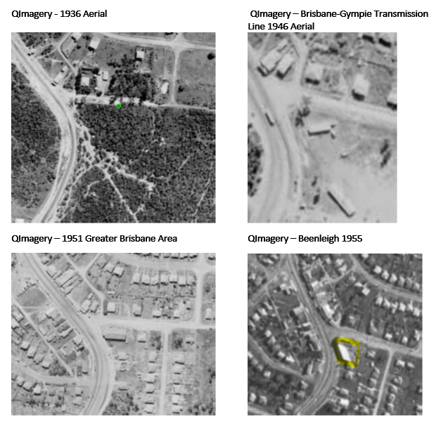
Aerial imagery illustrating development on the subject site.
References
-
Ancestry.com.
-
Brisbane City Council Building Cards
-
Brisbane City Council Detail Plans
-
Digitised newspapers and other records. http://trove.nla.gov.au/newspaper
-
Centre for the Government of Queensland. Queensland Places. www.queenslandplaces.com.au
-
Certificates of Title.
-
Queensland Post Office Directories
-
Queensland Electoral Roll
-
Kimberley Wilson (ed.) Brisbane Art Deco: Stories of our Built Heritage. Brisbane: Jubilee Studio, 2015
-
Peter Cuffley, Australian Houses of the Forties and Fifties. Knoxfield: The Five Mile Press, 1993
-
ABS. National Regional Profile: Moorooka (Statistical Local Area). http://www.abs.gov.au/AUSSTATS/abs@.nsf/Previousproducts/305091391Population/People12002-2006?opendocument&tabname=Summary&prodno=305091391&issue=2002-2006 (accessed 26 April 2017).
-
ABS. 2011 Census Community Profiles. http://www.censusdata.abs.gov.au/census_services/getproduct/census/2011/communityprofile/SSC31099?opendocument&navpos=220 (accessed 26 April 2017).
Citation prepared by — Brisbane City Council (page revised September 2020)