Addresses
Type of place
House
Period
Federation 1890-1914
Style
Vernacular
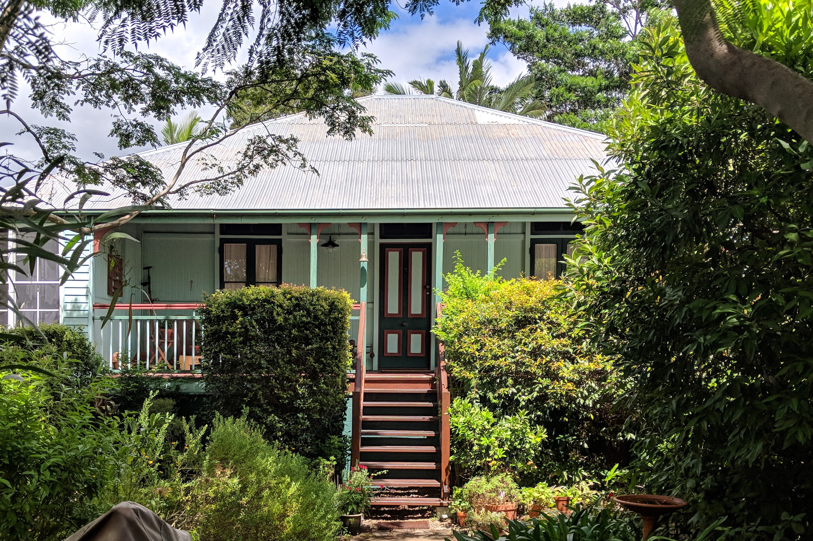

Residence from Lister Street
132 Lister Street, Sunnybank
Addresses
Type of place
House
Period
Federation 1890-1914
Style
Vernacular
This timber home was built in 1913 for John Edward Abson, a salesman, and his wife Florence. At the time, Sunnybank was still a small farming community of approximately 150 people. The property was then transferred to Ethel Godsmark in 1923 and it became the Godsmark family home for the next 40 years. As Sunnybank developed as a residential suburb in the late 1950s and 1960s, farms were displaced by housing estates. This property is a largely intact Federation-era dwelling which represents Sunnybank’s early settlement.
Lot plan
L1_RP108868
Key dates
Local Heritage Place Since —
Date of Citation —
Criterion for listing
(A) Historical; (B) RarityInteractive mapping
Lot plan
L1_RP108868
Key dates
Local Heritage Place Since —
Date of Citation —
Criterion for listing
(A) Historical; (B) RarityInteractive mapping
History
Sunnybank is a residential suburb, which was largely developed during the 1950s and 1960s from a largely rural community.
Little is known about the traditional owners of the area, however there were two known Aboriginal campsites near what is now Logan Road, and a third at Wally Tate Park in Kuraby. The area was comprised of grassy plains with densely wooded gullies and hills, which would have supported game foods such as kangaroos and emus, and provided wood for fires.
In October 1877, Samuel Gillespie took out a lease a block of 40 acres approximately where the Sunnybank railway station is now, naming his property ‘Sunnybrae’. This area was still designated Eight Mile Plains at the time. Due to growing demand, the South Coast railway was extended to Beenleigh in 1885, resulting in large-scale land resumption. The Gillespies lost approximately two acres of land to the railway line, however the railway station was named Sunnybank after their farm ‘Sunnybrae’ – the English version of “Brae” means hill or bank. With a growing population, Sunnybank was proclaimed a town in 1889.
During World War I, Sunnybank was proposed as a garden-city suburb for discharged service men in 1917, largely located north of the railway line, with a public reserve and radiating avenues. This caused the population to jump from 141 in 1911 to 670 in 1921, but limited population growth then occurred until after WWII. Sunnybank became a Ward of newly formed Brisbane City Council in 1925, and it was recorded that there were 400 houses in Sunnybank Ward at that time, with the area being predominantly dedicated to farms (vegetable growing interspersed with chicken farming, plant nurseries and dairy farms).
A residential suburb developed in late 1950s and 1960s and the farms were gradually displaced by housing estates. The major development of Sunnybank occurred between 1954 and 1976, with the population growing from 620 in the 1954 census to 7473 in 1976. In recognition of this, Sunnybank was officially gazetted as a suburb on 11 August 1975 by Queensland Place Names Board.
The subject property was originally part of a large estate of 91 acres 2 roods, purchased by John Thomas Phipps in August 1878. Phipps took out a mortgage of £150 against the property in August 1881. There is no record of him living on the property or improving it. The land was then transferred to Andrew James Patterson, a well-known Brisbane banker, in October 1882. In preparation for the railway extension to Beenleigh, just over 11 acres (Subdivision 3 of Portion 180) of Patterson’s property was transferred to the Commissioner for Railways. The remaining subdivisions (1, 2, 4, 5) totalled a sizable 80 acres 2 roods 18.75 perches. This land was transferred to John Henry Flower, in February 1885 and he took out a mortgage of £1000 on 9 January 1886. On 25 January 1886, the land was transferred to Andrew Bogle and Ernest William Pritchard. They retained ownership until October 1892 when the land was transferred to trustees.
The land was subdivided over the next several years, and in October 1913 Resubdivisions 8 and 9 of Subdivision 2 of Portion 180 was transferred to John Edward Abson, a salesman. He took out a Workers Dwelling Board mortgage for £279 in December that year. John Abson and his wife Florence are recorded in the Post Office Directories as living in Sunnybank from 1914, and in the Queensland Electoral Roll as residing in Sunnybank from 1915. They may have taken in a boarder as Edith Annie Maynard, a housewife, is also recorded in the 1915 Queensland Electoral Roll as living at “Abson’s, Sunnybank, South Coast Line”.
The Abson family advertised a four-roomed cottage on just over an acre, 3 minutes from Sunnybank Station for lease – presumably the subject property – in The Telegraph in March 1918. They are still recorded in the Queensland Electoral Rolls as living in Sunnybank in 1919, but move to Wilston by 1925. They may have rented the subject property to the Godsmark family from 1920, as the Godsmark’s had placed an advertisement in The Telegraph in March 1920 seeking to rent a small furnished home on the “south side”. The Godsmark family, however, are not recorded as living in Sunnybank until 1923.
The property transferred to Ethel Constance Godsmark, a spinster, on 27 June 1923, and she took out a mortgage on the same day as transfer through the State Advances Corporation. Ethel Godsmark took out a mortgage of £441 in October 1923. She married Joseph Stratton Wardley in June 1924, and her father Albert Godsmark is then recorded in the Post Office Directories as living in Sunnybank from 1924, and the Queensland Electoral Rolls from 1925. There is an advertisement in The Telegraph in December 1923, placed by “Godsmark, Sunnybank” but there is no name attached to the article.
The subject property transferred to Albert and Alice Godsmark on 19 April 1927, and they took out a mortgage on the same day. Albert died in 1940, but his wife Alice and daughter Dulcie appear to have continued living in the house. The property was subdivided in 1963 and Resubdivision 8 (with the subject house) was transferred to Dulcie Goldmark. Resubdivision 9, now 126 and 128 Lister Street, was transferred to Albert and Alice’s son Percy Godsmark.
The subject property was transferred to Ivan and Patricia Grams in December 1963, and in 1966 they subdivided the land in two to create Lot 1 on RP 108868 (now 132 Lister Street) and Lot 2 on RP 108868 (now 130 Lister Street). The Gram family retained ownership of the property until 1971, and the property has changed hands numerous times over the intervening years. Despite this, the property remains largely intact, with some modifications done in the 1920s and 1960s.
Description
The subject house is a one-storey timber house built in the Federation Bungalow style with a pyramid hip roof.
Sunnybank is a suburb of Brisbane located south of the central business district. It has a mostly residential character and a dense commercial centre. Residential buildings in the subject area are mostly single or double storey detached dwellings from the Post-war era with regular contemporary infill. Buildings on Lister Street have a medium setback from the street boundary. There is some streetscape continuity with a grassed verge and young trees located at regular intervals along the street.
There are limited views both to and from the site, with the house set back from the street which is not typical for houses on Lister Street. The property has a gravel drive, entering from street on the northern side of the site and leads to a modern carport. It is surrounded by a tall picket fence, which obscures much of the yard from the street. The garden is densely vegetated with mature trees, in both the front and back yards.
The roof is clad in corrugated iron and has quad gutters. Timber stairs lead to the verandah which features timber three-rail balustrades and posts with decorative brackets. External walls in the front verandah are clad in VJ with exposed framing and belt rails. Other external walls are clad in weatherboard. The subfloor has been enclosed with concrete masonry units and painted. The front entry door is timber panelled door with a fanlight and has an early iron doorknob and lock. There are glazed, timber French doors on either side of the entry door, which also feature fanlights.
Windows on the western elevation are double-hung tripartite windows with coloured glass panes and timber sills. The eastern and southern elevations have aluminium framed sliding windows and glass louvres. The rear of the house has a verandah with similar details to the front.
The interior has timber floors throughout. Internal walls feature VJ cladding with timber belt rails and early skirting boards and cornices. The house has timber batten ceilings. The doorways feature decorative breezeways, and the entry to the front living room features a decorative grill with cartwheel motifs in the corners and a suspended finial in the centre.
The subject house is in good condition and has had several alteration and additions.
The side, rear and a portion of the front verandahs have been enclosed and original verandah posts are still visible from under the house. A rear verandah has been added and an internal wall has been removed as evident in the oversized living room and the gaps in the skirting board and cornice.
Statement of significance
Relevant assessment criteria
This is a place of local heritage significance and meets one or more of the local heritage criteria under the Heritage planning scheme policy of the Brisbane City Plan 2014. It is significant because:
References
-
Brisbane City Council, Decko, https://sis-dekho.bcc.qld.gov.au/Dekho/, (last accessed 12 April 2018)
-
Brisbane City Council, Detailed Plan No. 50871-2 (2977), Brisbane: Department of Works, 1970
-
Department of Natural Resources and Mines, QImagery, https://qimagery.information.qld.gov.au/ (last accessed 12 April 2018)
-
Department of Natural Resources and Mines, Queensland Certificates of Title
-
Digitised newspapers and other records. http://trove.nla.gov.au/newspaper
-
Google Maps, https://www.google.com.au/maps/place/132+Lister+St+sunnybank, (last accessed 12 April 2018)
-
Nearmap, https://au.nearmap.com (last accessed 12 April 2018)
-
Brisbane City Council Properties on the Web
-
Queensland Electoral Roll
-
Queensland Post Office Directories
-
Coopers Plains Local History Group, Sunnybank – Runcorn Heritage Trail, (Brisbane: Coopers Plains Local History Group, August 2001)
-
Kerkhove, R. Aboriginal Camp Sites of Greater Brisbane – An Historical Guide. Salisbury: Boolarong Press, 2015
-
Queensland Places, Sunnybank, www.http://queenslandplaces.com.au/sunnybank (last accessed 19 March 2018).
-
Judy Gale Rechner, Brisbane House Styles 1880 to 1940: a guide to the affordable house, Brisbane: Brisbane History Group Studies No. 2, 1998
-
Roberts, Beryl. Stories of the Southside. Vol.1 (Archerfield; Aussie Books.1991)
Citation prepared by — Brisbane City Council (page revised September 2020)