Addresses
Type of place
Farm house
Period
Interwar 1919-1939
Style
Queenslander
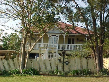

This is an image of the local heritage place known as Wall's Farmhouse
Wall's Farmhouse
Addresses
Type of place
Farm house
Period
Interwar 1919-1939
Style
Queenslander
This farmhouse was constructed in 1920 for James Henry Walls as part of the Workers Dwelling Scheme, developed to help low income earners purchase their own home. This high-set timber and tin Bungalow style house was one of only a few houses in the area constructed by the Workers Dwelling Scheme Board and is one of the oldest surviving residences in Coopers Plains as most of the older farmhouses were demolished in favour of new housing estates after World War II.
Lot plan
L2_RP101012
Key dates
Local Heritage Place Since —
Date of Citation —
Construction
Roof: Corrugated iron;Walls: Timber
People/associations
Workers Dwelling Scheme Board (Architect)Criterion for listing
(A) Historical; (B) Rarity; (D) RepresentativeInteractive mapping
Lot plan
L2_RP101012
Key dates
Local Heritage Place Since —
Date of Citation —
Construction
Roof: Corrugated iron;Walls: Timber
People/associations
Workers Dwelling Scheme Board (Architect)Criterion for listing
(A) Historical; (B) Rarity; (D) RepresentativeInteractive mapping
History
Coopers Plains is one of Brisbane’s oldest suburbs. It was first surveyed in 1826, when the commandant of the then Moreton Bay penal settlement, the infamous Captain Patrick Logan, named the area after his friend and the settlement’s medical superintendent Dr. Cowper (pronounced Cooper). Later the name Cowper’s Plains was corrupted into Cooper’s Plains. Logan based convict work gangs in the area, where they cut a road through the bush in order to link Ipswich with Brisbane.
After the closure of the penal settlement in 1842, free settlers were allowed into the colony and town and farming allotments were put up for auction. On 29 May 1868, John Soden purchased 160 acres at Coopers Plains. He paid ₤20 for uncleared land described as Portion 378 in the Parish of Yeerongpilly. Soden utilised his land for investment purposes. He obtained a ₤480 mortgage on the land through the Brisbane Permanent Benefit Building and Investment Society on 15 August 1882.
With the opening of the railway line to South Brisbane in 1885, Coopers Plains was seen as an area that could develop small dairy and poultry farms or orchards which would then freight their produce to the Roma Street Markets. So when Soden disposed of Portion 378 to Mathew Adam and William Rickett on 8 February 1886, the two partners planned to subdivide the site for the purposes of a land sale. To pay for the associated costs (fees charged by surveyor G.K. Jopp, road making etc), they took out a loan from David Mapleston and George Prentice junior. Adam and Rickett received ₤1,348 on 11 February 1886. They created “Orange Grove Estate” where they offered 160 allotments for sale, that were spread across an area bounded by a Government Road (now Orange Grove Rd) and Boundary Streets. It was proposed to cris-cross the estate with Cricket, Middle, Highgate, Hammersmith and Hill (now Nyleta) Streets. Special trains took prospective buyers out to either Cooper’s Plains or Salisbury train stations on 29 August 1885, so that the auction could be held on site. The auction must have been a failure for the first block did not sell until 18 June 1886. The other blocks also sold slowly so that the land sale continued through to the beginning of the twentieth century. As the estate was not located close to Coopers Plains Railway station, this was possibly why land sales were so slow. But the state did lend its name to the area so that part of Coopers Plains that was east of the rail line became known as Orange Grove. The persistence of this locality name was such, that when the Coopers Plains State School opened in 1931, it was called the Orange Grove School.
Mathew Adam died on 7 November 1919. Two of the last allotments to be sold before Adam’s death were Subdivisions 56 and 57 of Section 1 of Portion 378. This land, totalling 1 rood and 24 perches was sold to James Henry Walls on 9 April 1915. On 31 August of that year, Walls gained a mortgage for ₤298 from the Queensland Government’s Workers Dwelling Board in order to construct a residence on his land. With the First World War causing a shortage of skilled labour and building supplies, Walls was not able to get his residence built for a number of years. It is also possible that Walls served in the First Australian Imperial Force (A.I.F.), which meant that he would not have returned from overseas until 1919. He does not appear in the list Coopers Plains’ residents until the 1921-22 edition of the Queensland Post Office Directories. As the surveying for these directories was compiled during the year prior to publication, then it is assumed that the residence at 28 Nyleta Street was built in 1920. At the time of construction, Nyleta Street was still known as Hill Street.
The erection of Workers’ Dwelling Scheme homes was the responsibility of the Workers Dwelling Scheme Board (later renamed the State Advances Corporation) which was created by the state government in 1910. The purpose was to “enable persons of limited income to erect, under the Corporation’s supervision, suitable homes for themselves, with a comparatively small contribution by them towards the proposition, with easy terms of repayment, and a low rate of interest."1 By 1919, the cut-off level for eligibility for the scheme was set at an income of no more than ₤260 p.a. A 5% deposit was required with the balance of the loan repayable over the next 25 years with an interest rate of 5%. Walls’s occupation is not known but it is possible that he was a farm labourer who gained employment from the numerous orchards and dairies in the district. Such work was low-paid and so would explain how Walls was eligible to apply to this scheme. Walls selected a modified Type “K” design for his residence.
James Walls died on 27 April 1939 and surprisingly, his estate was not passed onto his wife Thelma but rather it went to Martha Emily Nalder, the wife of George Herbert Nalder. By 1946, the Walls’s residence was one of only seven houses that had been built in the Orange Grove Estate. The estate had not developed any further than the Hill, Hammersmith and Cricket Streets. The surrounding dense bushland had not been cleared to create Middle and Highgate Streets. The aerial 1946 photograph shows cultivated field on the land (Subdivision 55) next to the Walls’s property. This Orange Grove Estate block was not sold until 1948, when it came into the hands of the Walls family. This suggests that the family may have been farming Subdivision 55 before finally deciding to add it their holdings after World War Two. Thelma Caroline Walls finally regained ownership of her family home on 8 July 1948. On that day, she sold the property to Marie Ernestine Mann. Marie and her husband James Henry Mann lived at 28 Nyleta Street until 1960.
On 25 November 1960, Bevan Vivian Neilson and his wife Gwenifer Jean Neilson became the new owner’s of the Walls residence. They financed their purchase through the ANZ Bank. They only held the property for a short time before transferring ownership to Gladys Phillis Bradbury and her husband Robert Henry Bradbury on 15 February 1963. The Neilsons provided the loan that enabled the Bradburys to follow through with the sale.
Brisbane’s post-war housing boom caused many farming communities, like Coopers Plains, to be carved up into housing estates. Thus on 12 February 1963, while the final details of the sale of 28 Nyleta Street were being settled, the Bradburys had Subdivision 56 resurveyed. As a result, the block was divided into a large Resubdivision 1 and a smaller strip of land designated as Resubdivision 2. Then on 2 March 1965, the Bradburys sold both Subdivision 56 and Subdivision 57 to Amelia Donovan and Patricia Henley. The Henleys, in turn, sold Resubdivision 1 of Subdivision 56 to Leendert Lievaart, Theodorus Franciscus Schouten and Jacobus Henrillus Derick on 18 March 1965. This left the Walls’s Farmhouse on Subdivision 57 and Resubdivision 2 of Subdivision 56.
This 36.8 perches of land was purchased by Jacobus and Roelfina Janita Luchjenbroers on 29 June 1965, with the finance provided by the Hooker Finance Company. They utilised the property for investment purposes by remortgaging the property through Network Finance Limited on 24 August 1966. A third mortgage was taken out by the Commercial Bank of Australasia later in 1966. In the following year, the Luchjenbroers disposed of the Walls’s Farmhouse to George William Randall.
The Walls’s Farmhouse changed hands on a number of occasions during the next two decades. Randall sold it to Joyce and Michael Alwin Maxwell on 30 July 1976. On 4 January 1980, Peter and Roselie Fay McGovern became the new owners. The title deeds next passed to Peter James Kunkel and Sukli Finney on 30 November 1983. The current owner, Michael Argeros took control of the property on 3 April 1989.
Statement of significance
Relevant assessment criteria
This is a place of local heritage significance and meets one or more of the local heritage criteria under the Heritage planning scheme policy of the Brisbane City Plan 2014. It is significant because:
References
-
Workers‘ Dwelling Scheme, Information for Intending Applicants, (Brisbane: Queensland Government Printer, 1938)
-
Brisbane City Council, Properties on the Web, website, post-1946 building cards
-
Brisbane City Council, 1946 aerial photographs.
-
Brisbane City Council’s Central Library, local history sheets
-
Department of Natural Resources, Queensland Certificates of Title and other records
-
John Oxley Library, Brisbane Suburbs – Estate Maps, Orange Grove Estate
-
Queensland Post Office Directories, 1868-1949
-
Refidex Directory Maps, Greater Brisbane Area, (Brisbane: Refidex, 1924)
Citation prepared by — Brisbane City Council (page revised June 2022)