Addresses
Type of place
House
Period
Federation 1890-1914
Style
Queenslander

This is an image of the local heritage place known as Residence
58 Scott Street, Corinda
Addresses
Type of place
House
Period
Federation 1890-1914
Style
Queenslander
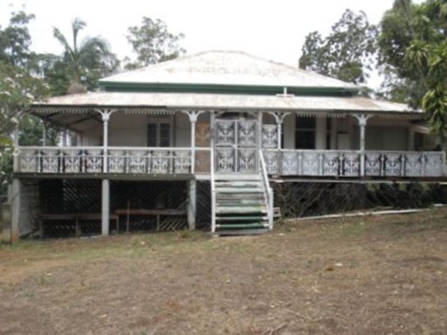
This large timber house was built for Charles W. Scott, a public servant, in 1902-3. While Corinda started as a farming locale in the nineteenth century, it gradually developed as a middle class residential suburb after the opening of the railway line from Ipswich to Brisbane in 1876. Although the verandah balustrading and valance do not appear to be original, the house’s original design and other external features are intact. Despite the subdivisions which have occurred at the rear and eastern side of the house, the house still has a substantial setting and has maintained its presentation to Scott Street providing a visual reminder of the development of the area over a century ago.
Also known as
Ongra
Lot plan
L3_SP246268
Key dates
Local Heritage Place Since —
Date of Citation —
Construction
Roof: Corrugated iron;Walls: Timber
Criterion for listing
(A) HistoricalInteractive mapping
Also known as
Ongra
Lot plan
L3_SP246268
Key dates
Local Heritage Place Since —
Date of Citation —
Construction
Roof: Corrugated iron;Walls: Timber
Criterion for listing
(A) HistoricalInteractive mapping
History
The area from Chelmer to Corinda was known as “Boyland’s Pocket” in the 1850s, Captain Boyland having leased the area in 1851. In 1860 the new Queensland Government opened up the district for selection, at a price of 1 pound per acre, resulting in the establishment of a number of farms ranging anywhere between 25 and 70 acres in size. Attempts were made by pioneer selectors during the 1860s and 1870s to produce maize, potatoes, bananas, cotton, sugar cane, and arrowroot. The opening of a railway bridge at Indooroopilly in 1876 reduced the isolation of the area, and allowed for increased subdivision. The first main building wave occurred in the 1880s, a boom period for Brisbane. However, many of the allotments sold at this time remained vacant for years, and continued to be used for small farming operations. Later waves of building, occurring after each of the World Wars, gradually reduced the amount of farmland, and new housing continues to envelop those gracious older houses which once stood on acreage, surrounded by gardens.
In 1902, Charles Waterson Scott acquired 1 acre and 2.6 perches in Corinda from Alfred Barton Brady. Born in Ipswich in 1865, Charles W. Scott was a clerk in the Lands Department, who had been appointed to the Civil service in 1885. In 1902 he had married Esther Mary Bennett. He was also the Patron of the Graceville Bowling Club, and a keen horticulturalist, as well as being Session Clerk of the Sherwood Presbyterian Church.
In 1902, 1903 and 1904 a Charles W. Scott is listed in the POD as living in Milford St, Ipswich, but in 1903 and 1904 a C.W. Scott is also listed as living in Corinda. In 1905 only the Corinda C.W. Scott is listed. Queensland Electoral records have Charles and Esther residing at Ongra in 1904, and thus the house was probably built around 1902-1903, with Scott having two addresses, one at Corinda and another at Ipswich, until 1904.
Charles died in 1954, and the land was willed to Margaret Falconer Widdowson and Shena Mary Tatham, presumably his relatives, in 1955. In 1956 Shena and Walter Tatham gained title to the bulk of the estate, 3 roods and .7 of a perch. Around 32 perches was subdivided in 1977, but the property has remained significant in size and remained in Ms Tatham's ownership until her death in 2008.
Statement of significance
Relevant assessment criteria
This is a place of local heritage significance and meets one or more of the local heritage criteria under the Heritage planning scheme policy of the Brisbane City Plan 2014. It is significant because:
References
-
Department of Natural Resources and Mines, Queensland Certificates of Title
-
Walter Taylor South Character and Heritage Study, BCC Heritage Unit, 1997
-
Queensland Post Office Directories
-
Queensland Electoral Rolls
-
Brisbane City Council Water Supply & Sewerage Detail Plans
-
McKellar's Map of Brisbane and Suburbs. Brisbane: Surveyor-General’s Office, 1895
Citation prepared by — Brisbane City Council (page revised June 2022)