Addresses
Type of place
Sportsground, Park
Period
Interwar 1919-1939
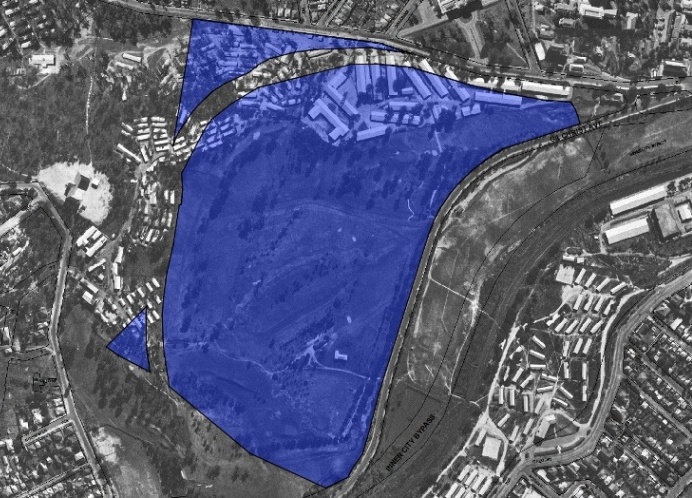

This is an image of the local heritage place known as Victoria Park Golf Course 1
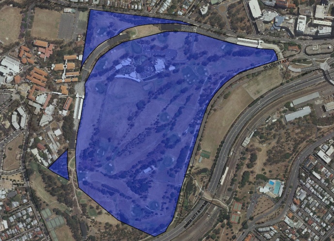
This is an image of the local heritage place known as Victoria Park Golf Course 2
Victoria Park Golf Course
Addresses
Type of place
Sportsground, Park
Period
Interwar 1919-1939
Lot plan
L4_SP150633; L5_SP150633; L3_SP150633
Key dates
Local Heritage Place Since —
Date of Citation —
Criterion for listing
(A) Historical; (B) Rarity; (D) Representative; (E) Aesthetic; (G) Social; (H) Historical associationInteractive mapping
Lot plan
L4_SP150633; L5_SP150633; L3_SP150633
Key dates
Local Heritage Place Since —
Date of Citation —
Criterion for listing
(A) Historical; (B) Rarity; (D) Representative; (E) Aesthetic; (G) Social; (H) Historical associationInteractive mapping
History
When the town of Brisbane was first surveyed in 1844, the site of the present Golf Course and surrounding lands were designated as a reserve. A series of parks was formed and, from the 1860s, the largest of these parks was known as Victoria Park. The subsequent development of Victoria Park has seen areas of the original reserve excised and allocated variously to the Royal Brisbane Hospital, Bowen Park, the Brisbane Grammar School, the railway and the Roma Street Railway Station.
The first Victoria Park Golf Club was formed in Brisbane in 1898 and a course was opened in November of that year. In the 1920s municipal golf courses were established throughout Australia, enabling broader social access to the game. In 1922, the Queensland Golf Association, eager to foster golf in the state, approached the Mayor of Brisbane, W.A. Jolly, with a proposal for a 9 hole municipal course at Victoria Park.
Since c.1906 a section of the park had been reserved as the site for a new University of Queensland, but in 1926 the University opted to build on land at St Lucia, donated by the Mayne family. The Queensland Golf Association saw this as an opportunity to establish a municipal Golf Course in Victoria Park and renewed its approaches to the then Greater Brisbane Council. This time the proposal was greeted enthusiastically. The course and clubhouse were eventually opened in November 1931, occupying the area of the Park west of Gilchrist Avenue (which was inserted through Victoria Park in 1930). W.A. Jolly, by then the first Lord Mayor of Greater Brisbane, became the inaugural president of the Victoria Park Golf Club and remained so until 1934.
The course was designed by Stan Francis, a surveyor and golfer, who presented plans to the Council in 1930. Francis’ plan, reflecting then-current thinking on course design, minimised extensive earthworks and allowed the Course to follow the natural contours, running along ridges, plunging into gullies and climbing steeply. Much of the construction work on the course was completed under the Intermittent Relief Scheme of the Depression period. The course layout has been altered nine times since its opening in 1931 but the general disposition of the original course has been retained. Along with physical changes to greens, tees and bunkers, the order of play has been revised a number of times.
The original clubhouse building, located at the Bowen Bridge Road end of the course, was designed and constructed in two stages during 1931 and 1939. It was designed in the office of the City Architect, A.H. Foster. Between 1942 and 1946 the 17th and 18th fairways were used as a barracks by the US Army. After the war these barracks housed ex-servicemen until the 1950s.
In 1975, a new clubhouse, also designed in the office of the then City Architect, was constructed on the site of the early 17th hole. The 1930s clubhouse was vacated at this time. It is now occupied by the Lone Parent Club and has no connection with the Golf Club. The former Victoria Park Golf Clubhouse was permanently entered in the Queensland Heritage Register in 1999.
Description
The Course
Victoria Park Golf Course occupies a portion of the larger Victoria Park, a recreational reserve on the northern edge of the central business area of Brisbane. Bounded by Herston Road, the Kelvin Grove Campus of the Queensland University of Technology, Victoria Park Road and Gilchrist Avenue, the Course’s hilly terrain affords spectacular views to the city, the Gateway bridge and the northern suburbs. The course covers eastern and southern hillsides, which undulate and fall, steeply in places, to the low lying areas beside Gilchrist Avenue. Brouwer notes that a considerable amount of planting was undertaken to establish the fairways. Belts of trees and other vegetation were used to form and separate each hole of the game. As a result there are many mature trees on the Course including jacarandas, camphor laurels, hoop and bunya pines, flame trees (Spathodia), coral trees (Erythrina) and palms (Pheonix dactylifera and Syagarua sp.). The 18-hole course consists of two sets of 9-holes each returning to the Clubhouse. The fairways are graduated over and around hills and gullies.
There are no water hazards on the course. Brouwer describes the effect of the course topography on the game:
The game of golf affords the participants a particular experience of the landscape of Victoria Park. The progress of the game and demands of the terrain encourage golfers to move at varying paces about the course, providing for the enjoyment of unfolding vistas, changing views of the horizon and the sky, and changing relationships with the vegetation. A familiarity with certain features in the landscape is established as landmark targets are selected for assisting in shot alignment and shot placement, a crucial component of play at Victoria Park (Brouwer p 8).
Buildings and structures
The following built elements are identified in Brouwer’s Assessment:
Former Victoria Park Clubhouse and surrounds
The former Clubhouse, designed by A.H. Foster, is entered in the State Heritage Register. Brouwer’s report identifies other significant built elements in its vicinity – a porphyry retaining wall to Herston Road and various concrete steps and buggy ramps.
Stone Steps, Gilchrist Avenue
These are located about half way along the former 1st fairway. They are made of concrete and hammered porphyry, with a moulded concrete plaque bearing the date 1936.
World War 2 Camp, Gun Base, Stone Wall & Flagpole.
These are remnants from 1942-46 when parts of the course became a US military camp.
New Clubhouse
The new clubhouse was built in 1975 and is accessed from Herston Road along a short bitumen driveway. The public areas of the clubhouse feature large glazed walls, offering panoramic views over the course and south towards Gregory Terrace. The rectangular building is dominated by its steeply raked, masonry end walls.
Memorials
There are a number of plaques scattered around the course, honouring persons closely associated with the Course and the Club.
Halfway House
This 1993 timber and masonry pavilion, designed in the office of the City Architect, is adjacent to the present 10th tee.
Statement of significance
Relevant assessment criteria
This is a place of local heritage significance and meets one or more of the local heritage criteria under the Heritage planning scheme policy of the Brisbane City Plan 2014. It is significant because:
References
-
Brisbane City Council - City Assets Branch Conservation Management Study Stage 1 Report. November 2002
-
Brouwer p 8
Citation prepared by — Brisbane City Council (page revised September 2020)