Address summary
Wynnum/Manly/Lota Foreshores - plus areas or parkland in road reserves & between road and sea
Addresses
- Along Esplanade , Lota, Queensland 4179;
- Along The esplanade , Manly, Queensland 4179;
- Along Waterloo Esplanade, Wynnum, Queensland 4178;
- Along Wynnum north Esplanade, Wynnum, Queensland 4178;
- Along Royal Esplanade, Manly, Queensland 4179
Type of place
Park, Reserve
Period
Federation 1890-1914
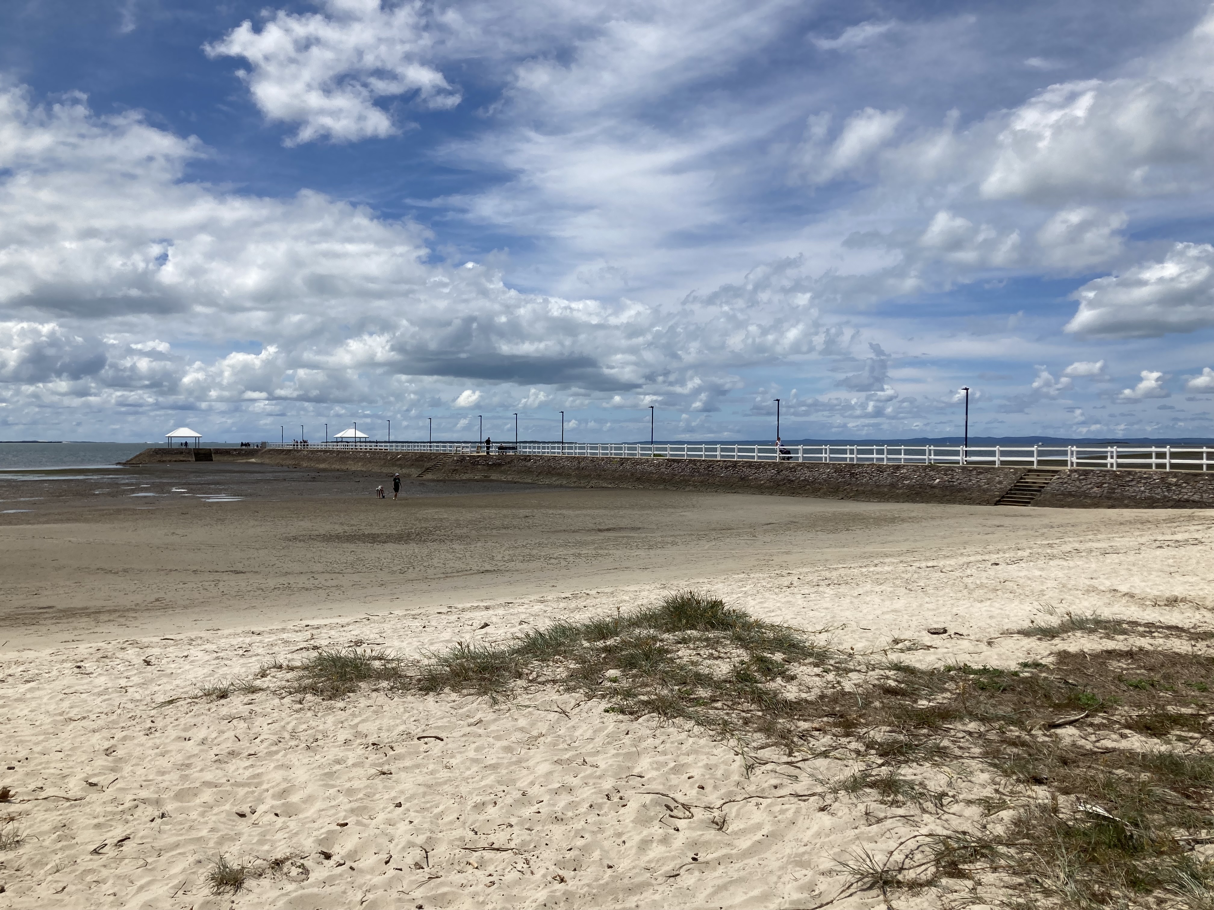

Wynnum Foreshore, including Wynnum Jetty
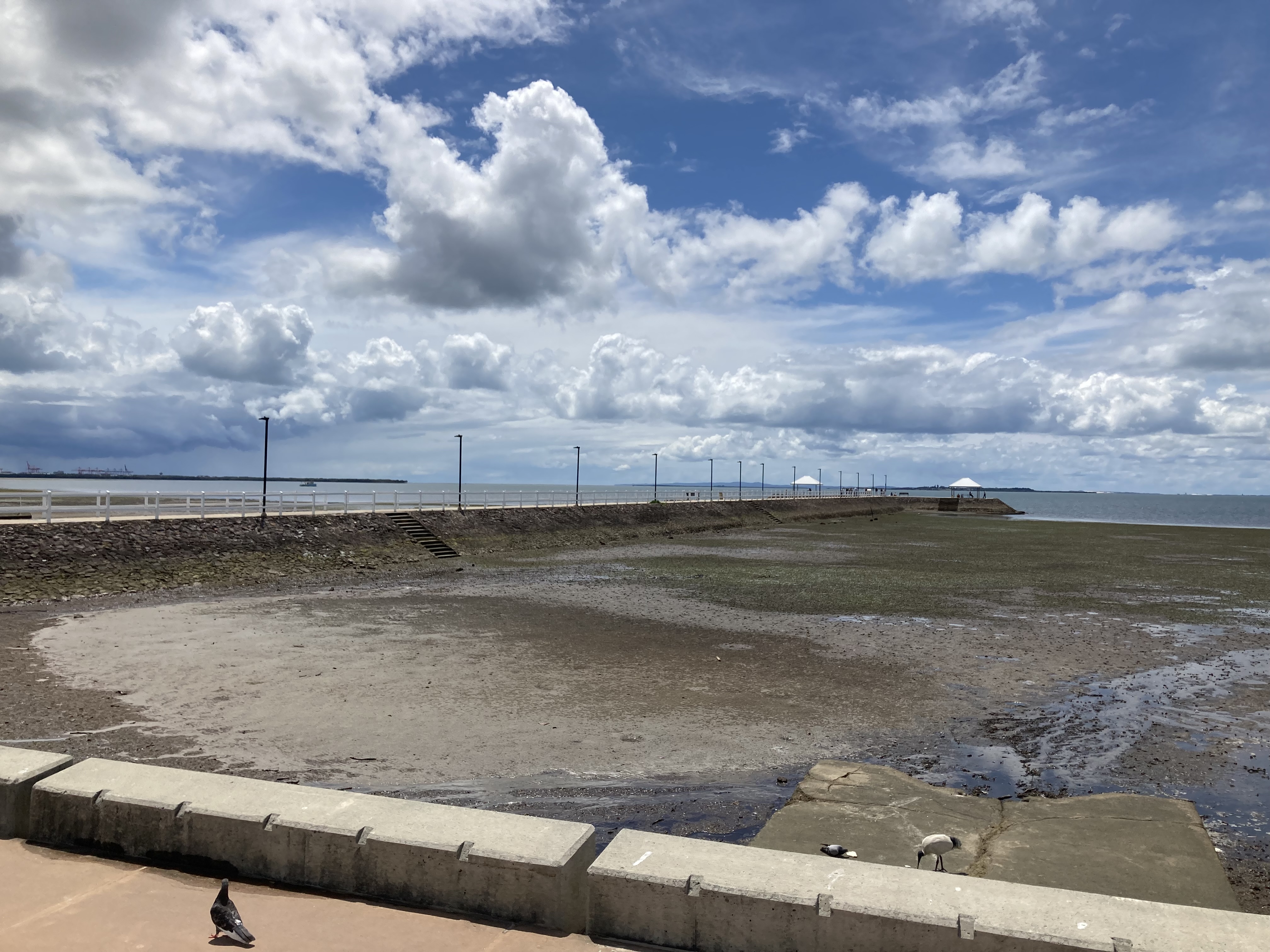
Wynnum Foreshore, including Wynnum Jetty
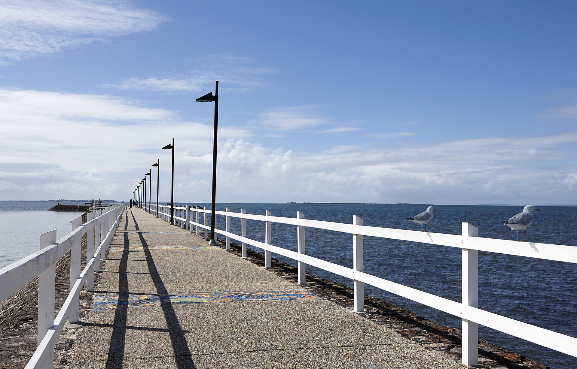
Wynnum foreshore
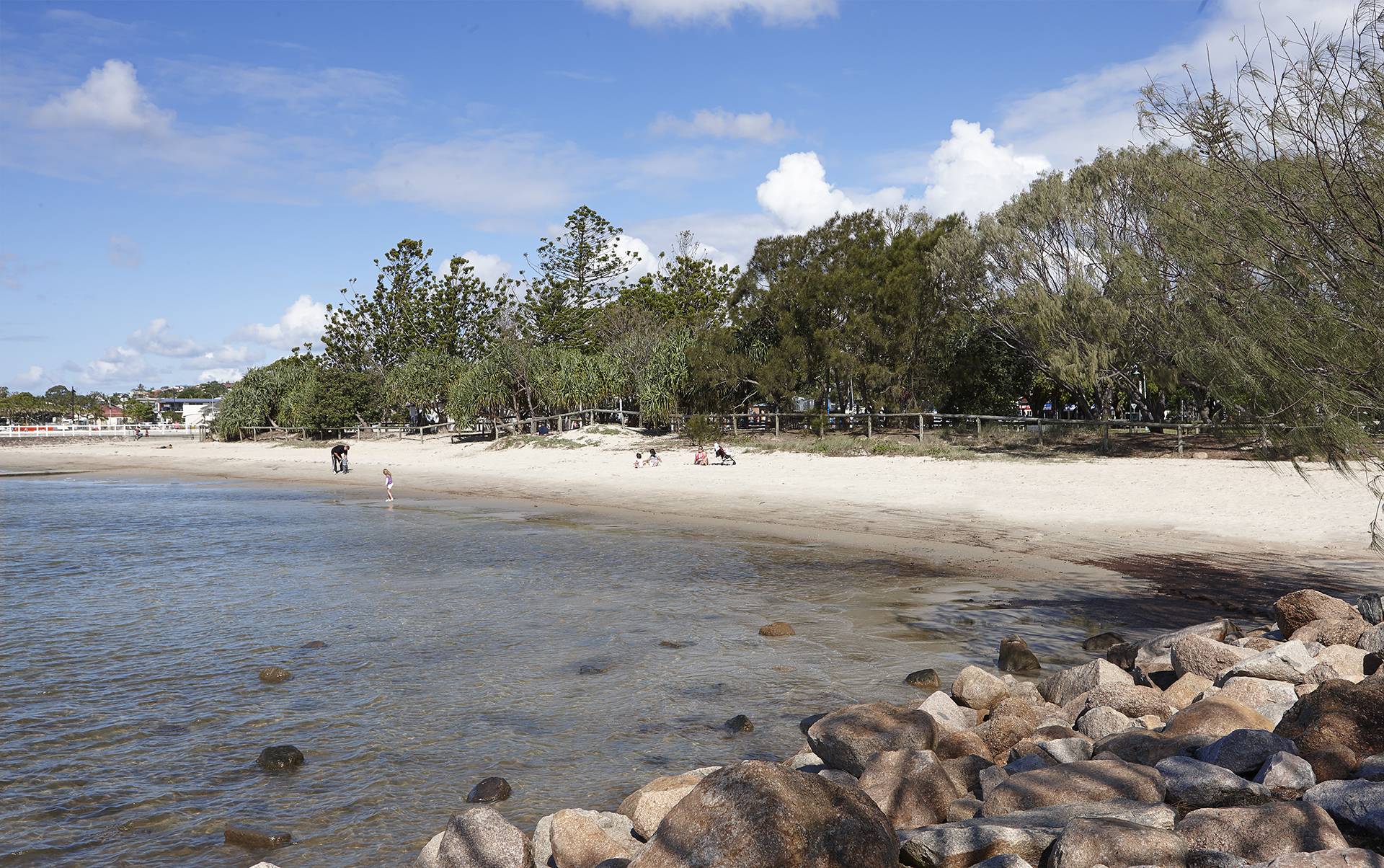
Wynnum foreshore
Wynnum / Manly / Lota Foreshores
Address summary
Wynnum/Manly/Lota Foreshores - plus areas or parkland in road reserves & between road and sea
Addresses
- Along Esplanade , Lota, Queensland 4179;
- Along The esplanade , Manly, Queensland 4179;
- Along Waterloo Esplanade, Wynnum, Queensland 4178;
- Along Wynnum north Esplanade, Wynnum, Queensland 4178;
- Along Royal Esplanade, Manly, Queensland 4179
Type of place
Park, Reserve
Period
Federation 1890-1914
The Wynnum/Manly/Lota Foreshores are a 16-kilometre stretch of parks fringing the Moreton Bay foreshore. Since the mid-19th Century, the foreshore has been a popular location for seaside recreation, including swimming, sailing, fishing and promenading. Multiple reclamation projects and improvements to the foreshore have taken place throughout the 19th and 20th Centuries, contributing to its role as a place to gather and enjoy seaside activities and views.
Lot plan
Key dates
Local Heritage Place Since —
Date of Citation —
Criterion for listing
(A) Historical; (D) Representative; (E) Aesthetic; (G) SocialInteractive mapping
Lot plan
Key dates
Local Heritage Place Since —
Date of Citation —
Criterion for listing
(A) Historical; (D) Representative; (E) Aesthetic; (G) SocialInteractive mapping
History
The early development of Wynnum
The first European record of the Wynnum/Manly/Lota Foreshores and the Moreton Bay area dates to 1770, when Captain James Cook named Moreton Bay and several features on the outer islands of the bay and when in 1799 Matthew Flinders sailed inside the islands to the inner bay.
In 1859, the area was surveyed by James Warner, whose survey map of Wynnum shows the coast as composed of ‘mud and mangroves, covered at high tide.’ The shoreline of Moreton Bay has been considerably altered since European settlement of the area.
The first land sales in the area took place in 1860 at Lytton and around Waterloo Bay. Most of the initial settlement was concentrated in the Wynnum North region. The area soon became popular with holidaymakers, and holiday homes were built along the Bay.
When land was subdivided in Lota, the land along the foreshore was reserved for the esplanade. Closer settlement of the area began in the 1890s, and by the 1920s, most of Lota had been developed. It has remained primarily a residential area but was a popular holiday spot in the 19th and 20th Centuries. Until 1973, people could camp at the lower end of the Esplanade.
The arrival of the railway line to Cleveland in 1889 further boosted the popularity of the Wynnum/Manly/Lota area, particularly as a seaside resort. The many guesthouses and camping sites, along with the provision of safe bathing areas, fishing and picnic spots, were marked features of the Wynnum/Manly/Lota Foreshores. The bay was well-sheltered and favourable for boating activities.
Farming and fishing remained the primary occupations for residents of the area. Oyster leases were established along the foreshore and creeks. A flourishing fishing industry was partially responsible for Wynnum's growth, and the fleet operating out of Wynnum Creek was the second-largest in Queensland and has a long association with the area with 28 fishing boats operating out Wynnum Creek in the 1930s.
The early development of the foreshores
The boat slip at Lota Creek is thought to be the first slip built to service Lota House. Constructed in the late 19th Century, the present slip is an upgrade of this earlier one. Lota House (1865) is the oldest surviving house in the area and was the residence of William Duckett White, whose property of approximately 350 acres extended from the Lota foreshore to Manly Road. White is said to have patrolled the cliffs above the beach to prevent day trippers from stealing oysters. Endeavouring to continue attracting holidaymakers and residents to the area, the local authority paid close attention to improving the amenity of the foreshore. Clearing of timber along the foreshore (where the esplanade parks are today) began in 1890, and bathing boxes were erected around the present Manly Pool.
The development of facilities included establishing the fish markets at Wynnum Creek and constructing slips and moorings for boating and fishing. Public baths were constructed at Manly, and a public bathing enclosure was constructed alongside Jetty No.1 at Wynnum Creek in 1891. The planting of shade trees along the Esplanade commenced in 1895.
To fund the improvements to the foreshore, in 1909, the Wynnum Council struck a special ‘Esplanade Improvement Rate’ on all properties in the Shire. In 1913, the sea wall between Jetty No.2 and Darling Point was constructed, and in 1915, a pavilion and kiosk were added to the Manly Jetty. The foreshore became known for its saltwater baths, play and picnic areas, shade trees and open grassed spaces.
By the late 1920s, access to the area was possible by rail, bus, or road, further increasing its popularity as a resort and as a place of residence for commuters working in Brisbane.
The later development of the foreshores
During William Jolly’s term as Lord Mayor of Brisbane (1925-1931), priority was given to constructing a durable arterial road system, acquiring more scenic viewpoints for public use and buying and improving public parks. Prompt attention was given to improving the foreshores at Sandgate, Wynnum and Manly with a view to increasing their attraction as seaside resorts. Plans were formed to reclaim portions of the foreshore to increase the available recreation areas. New arterial roads and improvements to the jetties made the areas more accessible and attractive to the public.
In 1933, a souvenir booklet for Wynnum observed:
There is an irresistible appeal about the Wynnum district to the holiday-maker and tourist. Its healthy climate, proximity to Brisbane and splendid transport services are a few among the many advantages which the district enjoys. To these may be added the invigorating sea breezes, magnificent views of Moreton Bay, whose islands stand out like rare jewels in a rich setting, and th everyday work of country life, carried on in many instances in full view of the glistening waves as they break on the grey sands of the beaches. (Back to Wynnum)
During the 1930s Depression, large-scale improvements were carried out along the Esplanade by relief workers engaged in civic improvement and beautification projects. This work included reclamation of 2.023 hectares (5 acres) of mudflats, formation of a drive to the Wynnum Jetty, construction of 610 metres (2,000 feet) of stone revetment wall and the Wynnum Wading Pool. Opened in 1933, Wynnum Wading Pool was constructed on parkland reclaimed from the sea. A revetment wall was built and backfilled, and an area was left empty to create the tidal pool. The pool is a large oval measuring 128 metres x 54 metres, with a depth of approximately 750mm at the centre. The pool has concrete walls and a sandy bottom, and a system of automatic valves to maintain the water depth against tidal flow. By 1935, the pool had earned a reputation for having a ‘bad odour.’
The stone seawall that supports the Wynnum Pier was another Depression-era project which allowed the flats to be reclaimed as parkland.
In 1958, work began on the Manly Boat Harbour, dramatically altering the environment of Manly’s coastline. Protective wave-break walls were built to the north and south, and gradual dredging took place between them. Dredging and land reclamation developed it into a safe haven for boats. The dredged soil was used to form the parks and parking areas adjoining the Harbour.
In 1987, a sandy beach named Pandanus Beach was formed to the north of the Wynnum Jetty. The beach was formed using sand from Stradbroke Island.
In 2000, the eastern end of the northern wave break of Manly Boat Harbour was gazetted as Norfolk Point, in honour of Lieutenant Matthew Flinders, who in the sloop Norfolk explored and mapped Moreton Bay in July 1799.
Greene Park, on the north bank of Wynnum Creek, is named for a prominent Wynnum family. The Greenes operated a timber yard, and John Greene was a builder and sawmiller. John Greene’s sons were building contractors in Wynnum and built most of the early buildings. They built and operated the Star Theatre, which burned down in 1959. Sam Greene, who published the Waterloo Bay Leader, was elected alderman in 1913 and is well remembered in the Wynnum and Manly areas. His son, John, was the last mayor of Wynnum and the second Lord Mayor of Brisbane.
Description
The Wynnum/Manly/Lota Foreshores is part of the Bayside Parklands, a 16-kilometre green ribbon of connected parks along Brisbane’s south-western edge of Moreton Bay. These parklands conserve the remaining tidal wetland and bushland habitats in the area and provide shelter for many wildlife species. They overlook the tidal flats of Moreton Bay Marine Park, an important feeding and resting ground for migratory wading birds.
The Wynnum/Manly/Lota Foreshores extend from the mangrove edge of Elanora Park in Wynnum, to the tidal mangrove swamp at the mouth of Lota Creek. Notable features along the foreshore include Elanora Park, Oyster Point, Greene Park, Pandanus Beach, Wynnum Jetty, Wynnum Wading Pool, Darling Point, Manly Beach, Norfolk Point, Manly Boat Harbour and Fig Tree Point. A ribbon of small parks runs along most of the length of the foreshore, interrupted only by the Manly Boat Harbour.
Expansive views of Moreton Bay and its islands are afforded from most locations along the foreshore. Views extend from the Port of Brisbane at Fisherman’s Island, around to St Helena Island, the sandhills of Moreton Island, to Green Island and Stradbroke Island. The Wynnum/Manly/Lota Foreshores are popular for picnics, promenading, walking, cycling, fishing, boating, informal sports and games, swimming, windsurfing, and birdwatching.
Elanora Park provides facilities and a large area of sporting fields for a number of sporting groups, including Wynnum Rugby Union. A prominent timber clubhouse distinguishes the Wynnum Rugby fields. A mangrove circuit boardwalk commences in Elanora Park and extends north through the mangrove swamp fringing the park.
A thin, open grassed park clings to the foreshore between Elanora Park and the mouth of Wynnum Creek. Mature Moreton Bay Fig Trees distinguish the parkland north of the creek. A concrete and stone slipway stands just north of the creek mouth, and breakwater groynes extend eastward on either side of it. The former Wynnum Fish Depot is accommodated just within the creek entrance, and boats, including the Wynnum fishing fleet, are moored along the creek edges.
Greene Park lies on the northern bank of Wynnum Creek and is bounded by Fox Street, Glenora Street, Wynnum Creek and Moreton Bay, and it accommodates a playground, picnic tables and shade trees. Further south, at the commencement of Wynnum Esplanade, the Wynnum Jetty is a notable feature. A stone sea wall supporting a fenced walkway, the jetty has allowed the flats to be reclaimed. A sandy beach, Pandanus Beach, has been formed to the north of the jetty with sand imported from Stradbroke Island. A tidal wading pool, Wynnum Wading Pool, stands within the park to the south of Wynnum Jetty. The pool fills at high tide, and seawater is retained by closing valves along the seawall.
A large sandstone monument with three former drinking fountains stands west of the jetty. It commemorates W.H. Barnes, M.L.A., a former State Treasurer who represented the Bulimba and Wynnum electorates from 1901 to 1933.
West of Darling Point, a finger of parkland lies between Lower Esplanade and Esplanade and accommodates a bandstand, picnic tables and shelters, BBQ facilities and a toilet block.
Darling Point protects the small bay formed by Manly Boat Harbour's north breakwater and offers views across Moreton Bay.
Manly Boat Harbour, the largest small-craft harbour in Queensland, was formed through reclamation and has since developed into a safe harbour for boats. The Harbour accommodates Manly Pool, marinas, docks and facilities for a number of clubs and organisations, including the Royal Queensland Yacht Squadron, Wynnum Manly Yacht Club and the Coast Guard. The eastern point of the northern wave break of Manly Boat Harbour is known as Norfolk Point.
The foreshore from the Manly Boat Harbour to the mouth of Lota Creek accommodates grassed open parkland with picnic tables, BBQ equipment and play areas. Fig Tree Point projects into Moreton Bay north of the mouth of Lota Creek and features extensive views across Moreton Bay. A concrete path commences near the top of Coolana Street and continues along the foreshore edge, diverting to follow the footpath west of Manly Boat Harbour, then reconnecting with the foreshore path beyond the Harbour, and continuing north along the foreshore edge to Elanora Park.
A concrete slipway and a set of stone stairs immediately north of the creek mouth allow boat and pedestrian access to the edge of the foreshore.
The mouth of Lota Creek accommodates areas of extensive mangrove swamps. Fragile, narrow timber jetties jut out into the swamp from the north grassed edge of the creek. Mangrove swamp lines the foreshore north from the mouth of Lota Creek, stopping a short distance south of the Manly Boat Harbour.
Several concrete and stone groynes of varying lengths and widths extend out into the flats along the length of the foreshore. A low stone retaining wall runs along most of the foreshore edge. The Manly Boat Harbour is sheltered to the south by breakwaters edged with a battered bank of loose, rough-hewn stones.
Statement of significance
Relevant assessment criteria
This is a place of local heritage significance and meets one or more of the local heritage criteria under the Heritage planning scheme policy of the Brisbane City Plan 2014. It is significant because:
Supporting documents
Citation prepared by — Brisbane City Council (page revised June 2026)