Addresses
Type of place
Quarry
Period
Victorian 1860-1890
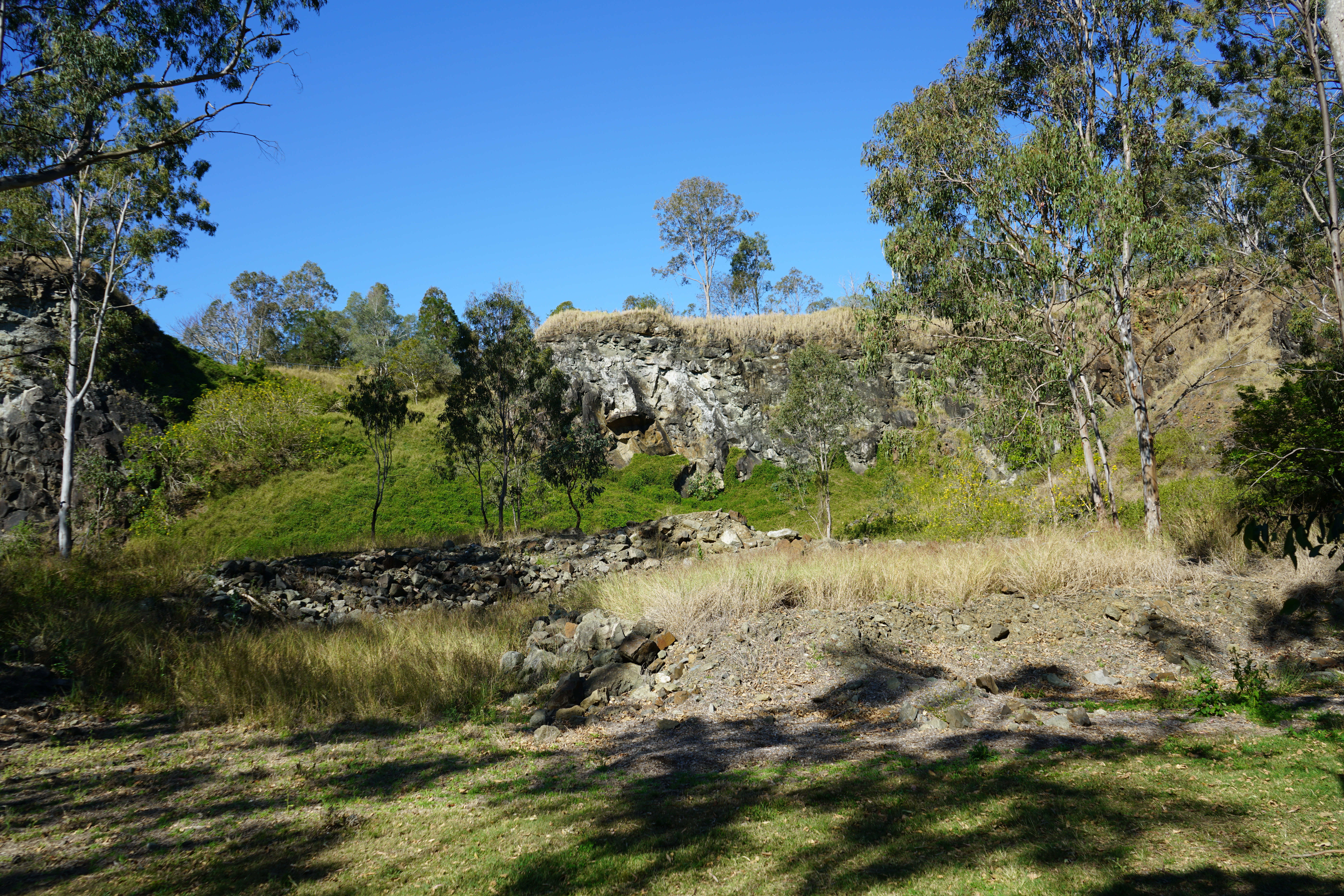

This is an image of the local heritage place known as Sugars' Quarry (former).
Sugars' Quarry (former)
Addresses
Type of place
Quarry
Period
Victorian 1860-1890
Opened in 1886 and originally named ‘Excelsior,’ the former Sugars’ Quarry in Anstead is a striking example of Brisbane’s early extractive industries. Representative of the evolution of the quarrying industry in Brisbane, Sugars’ Quarry demonstrates the importance of local industrial extractive activities that supported the development of Brisbane. The unique deposits of high silica basalt that were quarried here are known as Sugars Basalt and were used in various construction projects in Brisbane as aggregate for roads and concrete. Located by the Brisbane River, Sugars’ Quarry highlights the relationship between industry and the use of the Brisbane River as a primary form of transportation and trade in the late-19th and early 20th Centuries.
Lot plan
L174_S31116
Key dates
Date of Citation —
Criterion for listing
(A) Historical; (B) Rarity; (C) Scientific; (H) Historical associationInteractive mapping
Lot plan
L174_S31116
Key dates
Date of Citation —
Criterion for listing
(A) Historical; (B) Rarity; (C) Scientific; (H) Historical associationInteractive mapping
History
A history of Anstead
Anstead is an outer suburb of Brisbane, located 20 kilometres southwest of the Central Business District. The suburb is named after one of the first landholders in Moggill, John Anstead, who took up land in 1866. In 2011, the population of Anstead stood at 1,120. Before being gazetted in 1975, Anstead was part of the suburb of Moggill. At the same as the gazetting of Anstead, Queensland Government also created the suburb of Bellbowrie out of the former Moggill district. The intensified development in the area drove the creation of these two suburbs.
From the mid-19th Century onwards, critical industries in the Moggill area included farming, mining, quarrying and timber production. As early as 1823, Lieutenant John Oxley recognised the area’s agricultural potential and one of the first farms in the area was established by Job Twine, who arrived in 1849 with his family on one of Reverend Lang’s immigrant ships, the Lima. Farming continued to be important after much of the land in Moggill was cleared through logging. Dairy farms were established in the Moggill district throughout the late-19th Century and crops such as arrowroot, potatoes and corn were planted to provide extra income for dairy farmers. Livestock and poultry farms were also established in the district. Pineapple farms were an eye-catching feature of the Moggill landscape up until the 1990s.
The former Sugars’ Quarry is remnant evidence of the extractive industries that were also important to the local area. For example, by 1850, John Williams had begun mining the banks of the Brisbane River at Moggill for coal, though this mine was closed by the 1860s. However, coal mining resumed in the 1920s, when Riverside Collieries Proprietary Ltd recommenced mining at Moggill. Coal mining continued in the area up until the 1960s. Other important industries in the area included timber felling because of increased land sales in the Brisbane area and the associated construction of houses.
As the population gradually increased in Moggill, the need for certain services arose. By 1866 the district had a post office, a school, and a cemetery. Essential infrastructure in the area included the Moggill ferry, which has provided an essential public transport service connecting the Brisbane side of the Brisbane River to the Ipswich side since the 1870s. While the site of ferry operation has shifted over time, and a connecting bridge has been built over the Brisbane River to the Ipswich side further to the west, the Moggill ferry remains an extant example of late-19th Century public transportation. The ferry is an essential representation of early Brisbane public transport. Another vital piece of Brisbane’s infrastructure built in the area is the pipeline along the Mount Crosby Road that carries water from the nearby Mount Crosby Reservoir into Brisbane.
Sugars Basalt and the geological development of Brisbane
Since the start of European settlement in Brisbane, extraction and mining activities have been important local industries. As early as 1828, coal seams had been identified in the riverbanks of the Brisbane and Bremer Rivers. These extractive industries served in the growth and expansion of the Brisbane area by exploiting the natural resources of southeast Queensland. On initial settlement at Redcliffe the primary resource was timber and clay. However, on moving the settlement to what is now Brisbane, use was made of seashells for lime making and building stone along with brick clay and timber.
Around 220 million years ago, volcanic action created porphyry rock when hot ash was released and cooled over areas of present Brisbane. Suburbs affected by this action include West Chermside, Alderley, Windsor, Herston, New Farm, Kangaroo Point, Dutton Park and Carindale. At around the same time, molten magma rose through the earth's soft crust to form the ranges of hills surrounding Brisbane and the deposits of cooled lava, recognised today as basaltic rock. These deposits can be found at Moggill, Enoggera, Mount Coot-tha, Samford, White’s Hill, and Ashgrove.
The first quarry in Brisbane was opened at Kangaroo Point in the mid-1820s. This quarry extracted porphyry, a stone that became popular in the construction of municipal buildings in Brisbane. Other extraction activities sought to quarry different types of stone from areas in and around Brisbane, including basalt, as found at the former Sugars’ Quarry. Also known as Blue Metal, basalt is a hard, volcanic, high quality, and sharp construction stone sought after for road construction and as aggregate for concrete. The stone at the Sugars’ Quarry, is basaltic andesite, which differs from typical basalt due to the increased levels of silica present in the rock, making the formation at Sugars’ Quarry distinct from other types of rocks within the larger geological group of the area. The geological formation at Sugars’ Quarry forms part of the Kholo Subgroup, part of the Ipswich Basin. The Sugars Basalt was formed during the Late Triassic period between 229-232 million years ago due to a sub-aerial volcanic eruption. Named after the quarry, in 1925 Sugars Basalt was described as a ‘magnificent basalt formation’ that made an ‘interesting study for the geologist.’
The development and operation of Sugars' Quarry (former)
Beyond the initial quarry at Kangaroo Point, the extractive industry also played an essential role in Brisbane’s economic development into the 20th Century. The extractive industry also played a role in the Moggill area, with the harvesting of coal, sandstone and stone for road base being common in the district. Extraction of coal from the western bank of the Brisbane River (at the end of Weekes Road) started in 1850.
Ownership of the Sugars’ Quarry site – portion 174 – can be traced back to a deed of grant to Daniel Henry Sullivan in 1867. Portion 174, measuring 39 acres, was transferred to Thomas Sugars in 1883. Thomas Sugars had arrived in Moreton Bay with his wife and daughter in 1858. By 1883, Sugars already owned the land adjacent to this portion of land – portions 175 and 176, which was used for farming. A significant local landholder, Sugars was participated in civic and community matters in the area. In adding portion 174, Sugars’ landholdings in the Moggill area grew to 153 acres. In 1906, Sugars added portion 64, located to the south of portion 174, to his holdings. This brought the total land owned by Sugars in this area of Moggill to at least 199 acres. As well as his business interests, Thomas Sugars served as a member of the Indooroopilly Divisional Board, was a Justice of the Peace to the local community and was one of the earliest members of the Moggill Methodist Church. At the time of his death in 1915, Sugars was described as a ‘very old’ and ‘respected’ resident’ of Moggill.
In 1886, Sugars leased portion 174 to Colledge Bros. and Collin, who opened a quarry to extract ‘blue metal’ from the site. While leased by Colledge Bros. and Collin, Sugars was still listed as a proprietor. Sugars’ Quarry was originally known as ‘Excelsior’, named by Thomas Sugars’ daughter Eliza at its ‘opening ceremony’, held after despatching the first cargo of stones to Brisbane. While Colledge and Bros. enjoyed some early success in finding a market for the material extracted from Sugars’ Quarry, they quickly fell into financial problems. By 1887, the company had been liquidated, because of incurring debts of £1,026 5s and 10d in their first year of operations. During a meeting of creditors, it was noted that the company had installed all the necessary equipment required to operate a quarry, including ‘piping, a pumping engine, rails, wagons, sheds and tools.’
After Colledge and Bros. went into liquidation, the lease for the site was purchased in 1888 by ‘Messrs. Harding, Sugars and Collin.’ Thomas Sugars continued to operate Sugars’ Quarry under various guises until 1910, when the lease was sold to James Pringle Duncanson for ten years. Duncanson extended the lease for another ten years in 1913, and in 1915 the lease was transferred to Gravel, Sand and Metal Supply Limited, a company owned and operated by Duncanson. Gravel, Sand and Metal Supply Limited was a major supplier of various building and construction materials in Brisbane, with an office based in the Adelaide Chambers on Adelaide Street in the City and a depot on Stanley Street in South Brisbane. Ownership of the Sugars’ Quarry site passed to sons Thomas George and William Sugars after Thomas Sugars died in 1915. Like his father before him, Thomas George Sugars was an elected representative on the Indooroopilly Divisional Board and later, was a Councillor and Chairman of the Indooroopilly Shire Council. In 1916, the ownership of all the land owned by Thomas Sugars was transferred to sons William, Frederick, and Albert Sugars. William Sugars was at that time manager of the quarry. In 1924, after leasing Sugars’ Quarry, the title for portions 176, 175, 174 and 64 was transferred to Gravel, Sand and Metal Supply Limited, who owned the Quarry until 1950. In 1928 the company was described as carrying out extensive operations, employing many hands and had ‘erected a crushing plant (capable of nearly 1,000 yards per week), bins, and a jetty, the whole costing many thousands of pounds.’ This investment in infrastructure from a company experienced in supplying various construction materials in Brisbane, reflects the evolution of the quarrying process at Sugars’ Quarry. By the time Gravel, Sand and Metal Supply Limited purchased Sugars’ Quarry, the site was described as ‘one of the finest quarries in Australia.’
Over its roughly 65 years of operation, Sugars’ Quarry supplied thousands of tons of rock and provided a livelihood for generations of Moggill residents, including members of the Sugars’ family. When Sugars’ Quarry was established, Brisbane was a rapidly growing town, and in its first eight years of operation, around 60,000 cubic metres of crushed stone were shipped out. Most of the quarried stone was used in road and concrete making. The rock was used in the construction of government buildings and works.
Quarrying was hard and dangerous work in the late 19th and early 20th Centuries. Extraction methods consisted of blasting basalt from the rock face using explosives. Workers then used picks and shovels to load the rock into trolleys, usually keeping a pile of rocks some seven metres high between themselves and the rock face as a safety barrier against falling rocks. Trolleys laden with rock would then be hauled by man or horsepower to the steam-driven crushers at the edge of the quarry floor. The engine of the rock crusher depended on a large boiler that produced steam. Finally, at Sugars’ Quarry, the crushed basalt rock was loaded into river barges via timber chutes. Other important parts of the site included, for example, a Blacksmith’s shop that was located close to the engine and crusher.
The location of the Sugars’ Quarry meant that flat bottomed barges could cost-effectively transport stone and illustrates the importance of the Brisbane River as a means of transportation and trade in Brisbane in the late 19th and early-20th Centuries. Despite the growth in Queensland’s rail network in the late 19th Century, river transport remained a much more cost-effective means of transporting good. A steam-powered launch pushed the barges to transport the quarried stone, and journeys had to be timed to coincide with high tide due to rocks and sandbanks located upstream at Brisbane Junction. However, given its location by the Brisbane River, Sugars’ Quarry was susceptible to damage due to flooding as evidenced by the Great Flood of 1893, where ‘water covered a considerable portion of the works and plant.’
By 1928, some 20 men were employed at the quarry, and operations continued 24 hours a day. Quarrymen received nine shillings per day and stone breakers four shillings. Work was described as hard and hot, particularly in the afternoons when the quarry received the sun's direct heat. However, the wages were considered good and indicated a thriving industry. As with many industries at the time, injuries and deaths did occur. For example, in 1888, a James Walker suffered a ‘serious accident’ accident at the quarry site, though he eventually recovered. In 1934, Sugars’ son, Frederick Charles, who had continued to work at the quarry as a general hand, died in an accident when he was struck by falling basalt rock.
Council acquired Portion 174, including the former Sugars’ Quarry, on 23 August 1950 from Gravel, Sand and Metal Supply Limited for £600. The title was transferred in early 1951. In 1957, Council granted grazing rights over portion 174 to a Mr H. Hart for 12 months at £10 per annum and resumed Portions 175 and 176 from Brisbane Developments Pty. Ltd. for £8,000 in 1958. This land would also be given over to grazing under a lease to K.J. Randle at £65.10 per annum. Council purchased Portion 64 from Australasian Oil Exploration Ltd. in 1969 for quarry purposes, and, in 1975, Pioneer Quarries made an application to quarry this area. However, the proposal was met with much opposition from residents. At the time of the application, Pioneer Quarries owned Portion 63 to the south.
In 1960, a proposal was put to Council to undertake large-scale production from the former Sugars’ Quarry. However, local opposition persuaded Council not to proceed. Council infrequently crushed rock on the site to provide material for road maintenance until 1963. In 1967 another attempt was made to open Sugars’ Quarry. However, test drilling indicated that the remaining rock was extensively weathered and unsuitable for most uses. Thiess Brothers operated the quarry to gain road base material for local construction work between January and March 1976.
On 25 September 1995, Portions 174,176, and 64 were transferred to the then Department of Recreation and Health of Council for 'conservation, parkland and sporting fields. The former Sugars’ Quarry site thus became part of what in 2003 became known as the Anstead Bushland Reserve.
Description
Located in the Anstead Bushland Reserve approximately 20km south-west of the Brisbane Central Business District, the formers Sugars' Quarry is a significant remnant of the previously important quarrying industry in the Moggill District. The site includes a distinctive quarry landscape, including exposed quarry face, waste spoil heaps, remnant plant, and infrastructure.
General description
Situated along the banks of the Brisbane River, Sugars’ Quarry is just over 650m west of Hawkesbury Drive. The bluestone or basalt quarry remains are concentrated within 250m of the riverbank and are adjacent to the powerline easement. The area is accessed by a partially sealed and driveable road, Quarry Access Road, off Hawkesbury Drive, and by hiking or walking trails.
Farthest east, and reaching approximately 15m at its highest point, the basalt quarry face is split into two 100m long segments, each sloping towards the river. Quarrying and erosion have caused a depression between the two segments, consisting mainly of a heavily vegetated spoil heap. Other loose and heaped spoil can be found along the length of the quarry face and are retained by a continuous line of larger rocks. A wire perimeter fence separates the rocks and mullock from an open grassed area. Two extensive, though low height, spoil heaps lie within the grassed area.
The site also includes remnants of plant used while the mine was operational. Concentrated 40m from the riverbank in the south-west portion of the site, remnants include a boiler, rail lines, engine mounts and loading platforms. Thick vegetation, and small spoil mounds surround the plant remnants.
There are two lookouts located within the quarry; one above the northern-most quarry face (Quarry Lookout), and one located south of the remaining plant (River Lookout). Wire perimeter fencing and interpretation or information signage can also be found around the site. None of these elements are considered to have cultural heritage significance.
Significant Features
Features of cultural heritage significance include:
- Views to the quarry from the Brisbane River
- Views to the Brisbane River from the quarry
- Views across the site to the quarry
- Quarry face and form, including depression
- Location and size of spoil mounds
- Location and size of large rocks, and other quarrying waste
- Location of remnant plant and associated artefacts, including (but not limited to):
- Boiler
- Rail lines
- Engine mounts
- Loading platforms
- Open, grassed area between quarry face and riverbank
- Mature vegetation along riverbank, and around quarry (setting), excluding weeds and regrowth since the mid-1970s
- Potential archaeological artefacts associated with the operation of the former quarry
Non-significant elements
Non-significant features include:
- Lookout above the quarry face (Quarry Lookout)
- Lookout adjacent to the remaining plant (River Lookout)
- Perimeter fencing
- Interpretative and information signage
Statement of significance
Relevant assessment criteria
This is a place of local heritage significance and meets one or more of the local heritage criteria under the Heritage planning scheme policy of the Brisbane City Plan 2014. It is significant because:
Supporting documents
prepared by — Brisbane City Council (page revised September 2025)