Addresses
Type of place
House
Period
Interwar 1919-1939
Style
Queenslander
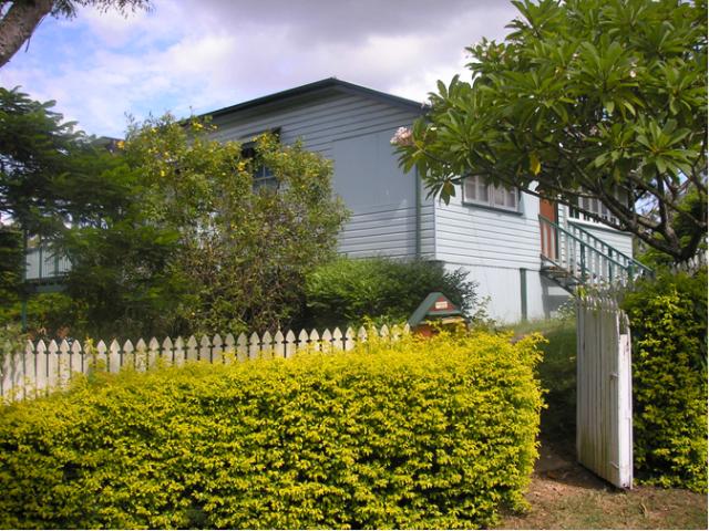

This is an image of the local heritage place known as Residence (Cottage No 133)
Waterworks Cottage No. 133
Addresses
Type of place
House
Period
Interwar 1919-1939
Style
Queenslander
This 1920s timber and tin workers’ cottage is of heritage significance because of its association with the Mount Crosby Water Treatment Works; the establishment and functioning of which gave rise to this and other purpose-built housing in the Mount Crosby area.
Lot plan
L11_RP904286
Key dates
Local Heritage Place Since —
Date of Citation —
Construction
Roof: Corrugated iron;Walls: Timber
Criterion for listing
(A) Historical; (D) Representative; (H) Historical associationInteractive mapping
Lot plan
L11_RP904286
Key dates
Local Heritage Place Since —
Date of Citation —
Construction
Roof: Corrugated iron;Walls: Timber
Criterion for listing
(A) Historical; (D) Representative; (H) Historical associationInteractive mapping
History
This timber and tin workers’ dwelling was built to house the families of employees of the Mount Crosby Water Treatment Works.
Droughts during the 1880s revealed the limitations of Brisbane’ water supply which relied on the Enoggera and Gold Creek reservoirs. Legislation was enacted to allow the city to draw water from the Brisbane River at Mount Crosby. A pumping station was erected on the east bank and delivered water by pipeline to a high-level reservoir one kilometre away on an outlying knoll of Mount Crosby. The water was piped 30 kilometres to Brisbane using gravitation. As water needs for the Brisbane area increased the Mount Crosby facility was expanded. A water treatment and chlorination plant and a new weir at Mount Crosby commenced operation in 1926. Further water storage facilities were constructed. In 1928 responsibility for the waterworks were handed over to the Brisbane City Council from the Metropolitan Water Supply and Sewerage Board.
Staff employed to develop and operate the pumping station and later water treatment works were accommodated in houses built for them on land resumed from local landowners by the Metropolitan Water Supply and Sewerage Board. Two distinct villages developed, along with a number of more isolated dwellings associated with outlying water treatment structures. This reflected housing requirements as the plant expanded. The original village, built with an informal layout and orientation in the 1890s, coincided with the commissioning of the Mount Crosby Pumping Station. In contrast is the more formal strip development layout of the village located at the intersection of Mount Crosby Road and Stumers Road in which this house is located. Cottages in this area are typical of styles of the 1920s.
Due to south-east Queensland’s population growth from the 1970s, and the resultant suburban spread, Mount Crosby became urbanised. Throughout the 1970s and more dramatically during the 1980s and 1990s the number of resident employees decreased. As a consequence of this reduction, the decision to transfer the employee houses into private ownership was made. The first auction of Brisbane City Council employee housing at Mount Crosby occurred in 1997, followed by a second auction in 1999. The last stage of the transition of Mount Crosby into a Brisbane suburb occurred when it was incorporated within the municipal boundaries in March 2000.
Description
This detached timber house is clad with weatherboards and has a corrugated galvanised iron roof. The front verandah has been enclosed and front stair and handrails replaced. Concrete stumps have replaced the original timber stumps. A timber deck has been added at the rear.
Statement of significance
Relevant assessment criteria
This is a place of local heritage significance and meets one or more of the local heritage criteria under the Heritage planning scheme policy of the Brisbane City Plan 2014. It is significant because:
References
-
Department of Natural Resources, Mines and Energy. Titles information.
-
Nissen, Judith, 'Creating the landscape: A history of settlement and land use in Mount Crosby' School of History, Philosophy, Religion and Classics, University of Queensland (1999)
-
Professor Ray Whitmore. Mount Crosby Waterworks Heritage Study: Its History, Cultural Significance and Tourism Potential. Heritage Unit, Dept Development and Planning, BCC, August 1992
-
Brisbane City Council Heritage Unit. Report on Preliminary Inspection of Dwellings at Mount Crosby Treatment Plant. Heritage Unit, Dept Development and Planning, BCC, 1991
-
Extended Ipswich Heritage Study
Citation prepared by — Brisbane City Council (page revised September 2020)