Addresses
Type of place
Roadway, Cutting
Period
Interwar 1919-1939
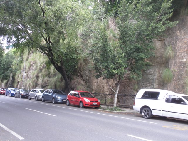

This is an image of the local heritage place known as Cutting
Cutting
Addresses
Type of place
Roadway, Cutting
Period
Interwar 1919-1939
This roadside cutting was completed in 1920 as part of the construction of Macquarie Street. It is a rare exposed geological feature within the inner city. With its exposed rock face, the cutting has considerable natural appeal.
Lot plan
L4_RP204381
Key dates
Local Heritage Place Since —
Date of Citation —
Construction
Walls: Porphyry;Walls: Stone
Criterion for listing
(A) Historical; (B) Rarity; (E) AestheticInteractive mapping
Lot plan
L4_RP204381
Key dates
Local Heritage Place Since —
Date of Citation —
Construction
Walls: Porphyry;Walls: Stone
Criterion for listing
(A) Historical; (B) Rarity; (E) AestheticInteractive mapping
History
Geologically this rock face exposes part of the Neranliegh – Fernvale beds, which make up a proportion of the bedrock landform beneath Brisbane City. Laurie Hutton and Andrew Stephens describe the Devonian period within Palaeozoic epoch in which these rocks became part of Brisbane’s landmass in their article “Geological Development of the Brisbane Region”.
“About 370 million years ago the present site of Brisbane lay in a deep sea trench. The coastline was to the east of Toowoomba. The exact locality of the coastline is uncertain but the rocks deposited on the continent at this time occur in the Mount Barney area, south west of Brisbane.
The climate was probably temperate. Simple woody trees, known as giant clubmosses and giant horsetails, similar to modern horsetails grew on the continent. Land animals were restricted to simple amphibians, which were beginning to emerge from the oceans to live on the land.
At the beginning of this period, the Brisbane region lay at about 30 degrees south. The Australian continent was drifting southward and rotating clockwise. By the end of the first episode, Brisbane lay at about latitude 50 degrees south and had rotated so that the coastline ran north-easterly. The Brisbane area lay on the leading edge of the continent as it shifted.
As the continent moved, it over-rode the thinner crust under the ocean, forcing it downward into the mantle. As the oceanic crust plunged beneath the continent, a trench formed at the margin. This trench was then filled with sediment, some of which was washed down from the continent by rivers and streams, across the continental shelf and into the developing trench. At the same time, sediment which formed on the ocean floor, and volcanics which made up the ocean crust, were scraped off the ocean floor and mixed with the sediment from the continent in the trench.
With time, the trench was filled with sediment which was then “bulldozed” by the advancing continent, forming a folded and contorted mass of rock. This folded rock was pushed up to form a mountain range which then became part of the continent.
The process of accumulation of sediment in the trough, folding and contortion, and accretion of the rocks to the Australian continent probably took place between 370 to 250 million years ago. The exact timing is uncertain, but by 250 million years ago, these folded sedimentary rocks were part of a mountain range on the continent. They still form a range today – the “ D’Aguilar Range – and occur in a belt extending from Eaton’s Hill, Everton Park, Red Hill and Indooroopilly through to Carina and Pine Mountain on the south side”.
The toe of the hill on which Mole Street and Walker Avenue are located was first cut prior to 1914 to accommodate the railway serving the wharves of Dalgety & Company Limited and the Brisbane Stevedoring & Wooldumping Company Limited along with the Colonial Sugar Refining works.
This cutting was approved for expansion in 1916 after the Brisbane City Council had decided two years previously that Macquarie Street should be constructed from Vernon Terrace to Merthyr Road. Excavation on the site was begun about July 1914 when quarrymen were moved from a Council quarry in Gregory Terrace, Spring Hill to the site which was then part of the land owned by the Brisbane Stevedoring & Wooldumping Company Limited.
The dedication of the extension of Macquarie Street as a public road was not finalised by 1920, however maps of 1925 and 1927 confirm the completion of the cutting which still reveals the uplifted and folded stone. In some areas of the face, the formation has a dip of some 70 degrees or greater.
The cutting also shows layers of clay and shale interspersed between irregular rocks. From these veins yucca plants and weeping fig trees have grown. This vegetation has caused the fragile metamorphosed sediments within the makeup of the cut to expand at the numerous cracks and openings over its face. In some places maintenance work by way of porphyry wall construction exists. While not in absolute keeping with the natural face of the cut, the work, with the help of the vegetation, does blend with the remainder of the face of the cut. Some work may need to be carried out on the face to lessen the current risk of falling rock and shale.
The probability of this geological phenomenon being so clearly displayed at any other public place within the Newstead – New Farm area of Brisbane is remote and therefore this example in its current form is considered highly significant.
Statement of significance
Relevant assessment criteria
This is a place of local heritage significance and meets one or more of the local heritage criteria under the Heritage planning scheme policy of the Brisbane City Plan 2014. It is significant because:
References
-
Brisbane City Council Minutes of Meetings, 1906 – 1921
-
Brisbane City Council Works and Water Supply Department plans and records
-
Brisbane History Group Papers No. 10 (1991) “Geological Development of the Brisbane Region” Laurie Hutton and Andrew Stephens
Citation prepared by — Brisbane City Council (page revised June 2022)