Address summary
Bramble Bay Foreshores, includes the seawall, Shorncliffe / Sandgate Pier and Baxter's Jetty
Addresses
- At Flinders Parade, Sandgate, Queensland 4017;
- Along Eagle Terrace, Sandgate, Queensland 4017;
- Along Eagle Terrace, Shorncliffe, Queensland 4017;
- Along Park Parade, Shorncliffe, Queensland 4017;
- Along Shorncliffe Parade, Shorncliffe, Queensland 4017;
- Along Swan Street, Shorncliffe, Queensland 4017;
- Along Allpass Parade, Shorncliffe, Queensland 4017
Type of place
Natural feature, Park
Period
Victorian 1860-1890
Bramble Bay Foreshores, includes the seawall, Shorncliffe / Sandgate Pier and Baxter's Jetty

Bramble Bay Foreshore and Shorncliffe Pier
Bramble Bay Foreshore
Shorncliffe Pier
Shorncliffe Pier
Bramble Bay Foreshore, Shorncliffe Pier and scultpture
Bramble Bay Foreshores
Bramble Bay Foreshores, includes the seawall, Shorncliffe / Sandgate Pier and Baxter's Jetty
Address summary
Bramble Bay Foreshores, includes the seawall, Shorncliffe / Sandgate Pier and Baxter's Jetty
Addresses
- At Flinders Parade, Sandgate, Queensland 4017;
- Along Eagle Terrace, Sandgate, Queensland 4017;
- Along Eagle Terrace, Shorncliffe, Queensland 4017;
- Along Park Parade, Shorncliffe, Queensland 4017;
- Along Shorncliffe Parade, Shorncliffe, Queensland 4017;
- Along Swan Street, Shorncliffe, Queensland 4017;
- Along Allpass Parade, Shorncliffe, Queensland 4017
Type of place
Natural feature, Park
Period
Victorian 1860-1890
The Bramble Bay Foreshores consist of more than seven kilometres of continuous publicly accessible parklands at Sandgate, Shorncliffe and Brighton. Sandgate had become a popular seaside resort in the late nineteenth century, and between then and the mid-twentieth century public facilities including kiosks, piers, jetties, a lovers’ walk, bathing facilities and entertainment venues were added to the area. Surviving features of this era include the Sandgate pier (built 1882), Baxter’s Jetty (1880s; replaced 1923) and porphyry sea walls, part of which is a groyne built near the jetty to create a shark-proof enclosure. The pier is a rare surviving intact example of a seaside pier, the only large timber pier in the greater Brisbane area. The natural and built features of the foreshore enhance the setting of many substantial residences in the area, and the parkland affords extensive view of Bramble Bay.
The Bramble Bay Foreshores comprise continuous publicly accessible parklands stretching for more than seven kilometres along the foreshores of Bramble Bay, featuring the Sandgate pier and swimming pool, Cabbage Tree Head, Baxter’s Jetty, the groyne and Lover’s Walk. The natural and built features of the foreshores demonstrate the changing patterns of use of the Moreton Bay littoral areas. The Shorncliffe, Sandgate and Brighton foreshores have undergone many changes since the area’s early days as a seaside resort. Large recreational facilities such as the kiosk and baths have been demolished, but significant structures such as the Pier and Baxter’s Jetty remain. The development of and remnants of the foreshore parkland areas illustrate the evolution of Sandgate from a premier beach and recreational destination to desirable bayside suburb. Together with Moora Park, the foreshore parklands accommodate many surviving features from these days – the sea wall, jetties and piers. The pier is a rare intact example of a seaside pier. The foreshores enhance the setting for many substantial residences on Flinders Parade and offer a great variety of serene Moreton Bay seascapes. The craftsmanship evident in large portions of the sea wall and the strong linear form of the pier provide a built counterpoint to the natural landscape. The parkland has a long association with local residents and is popular with visitors
Lot plan
L307_SL6504; L415_SL11521; L414_SL11521; L416_SL11521
Key dates
Local Heritage Place Since —
Date of Citation —
Criterion for listing
(A) Historical; (B) Rarity; (D) Representative; (E) Aesthetic; (G) SocialInteractive mapping
Lot plan
L307_SL6504; L415_SL11521; L414_SL11521; L416_SL11521
Key dates
Local Heritage Place Since —
Date of Citation —
Criterion for listing
(A) Historical; (B) Rarity; (D) Representative; (E) Aesthetic; (G) SocialInteractive mapping
History
Prior to European settlement, the area was known as “Moora” or “Warra”, meaning “open sheet of water”. The indigenous people enjoyed abundant food resources in and around the lagoons, mangroves and bushlands of the area.
In September 1852 surveyor James C. Burnett had mapped the locality and forwarded the plan to the Surveyor-General’s office in Sydney. It appears that the Survey Office chose the name Sandgate. On his survey, Burnett marked the cliffs overlooking Bramble Bay as “Shorncliff” and as the popular seaside resort of Sandgate adjoined the military installation of Shorncliffe in Kent, the two English placenames were similarly coupled in the colonial situation. On 22 March 1853 the New South Wales Government Gazette announced that a site had been fixed for a village at Sandgate, on Cabbage Tree Head, in the district of Moreton Bay. On 9 and 10 November 1853 the first government auction of land took place for allotments at Sandgate. The lots offered for sale extended from Wharf Terrace and Yundah Street in the south to Eagle Terrace and Signal Row in the north. This was the largest land sale to be held in Moreton Bay at that time. The first European settler to the area was Thomas Dowse who took up three allotment to the mouth of Cabbage Tree Creek.
The bridging of Cabbage Tree Creek in 1861 made Sandgate more accessible to visitors. During the next 20 years three coach companies operated regularly between Brisbane and Sandgate. Development was greatly boosted by the opening of the Sandgate Railway in May 1882 which provided a quick and efficient train service for the growing number of residents commuting to Brisbane, and holiday-makers and daytrippers.
By the time the Town of Sandgate was proclaimed in 1902, Sandgate had become a popular seaside resort renowned for its seaside activities and sailing regattas. Moora Park and the Shorncliffe foreshores were the focus of holiday activity in the 19th century and public and private bathing boxes were erected for the convenience of holiday crowds and guesthouse patrons. Sandgate boomed as a seaside resort in the 1920s and 1930s. A variety of entertainments were on offer including boxing and wrestling tournaments held in the town hall and movies screened at the picture theatres – the Beach, Bon Accord and Felix theatres or on the open air screens near the pier and kiosks.
During William Jolly’s term as Lord Mayor of Brisbane, priority was given to the construction of a durable arterial road system, the acquisition of more of Brisbane’s scenic viewpoints for public use and purchase and improvement of public parks. Prompt attention was given to the improvement of the foreshores at Sandgate, Wynnum and Manly with a view to increasing their attraction as seaside resorts. At Sandgate swimming baths were constructed and the foreshores improved. Plans were formed to reclaim portions of the foreshore to increase the recreation areas available. The construction of good arterial roads and improvements to the jetties made the area more accessible and attractive to the public.
By the mid-1930s Flinders Parade (then known as Brighton Esplanade), between First Avenue and Gladstone Street (now Twelfth Avenue), was dotted with cafes, refreshment rooms, flats and boarding houses. Attractions on the foreshores included sand-garden competitions, donkey, goat and gig rides, canoe hire and a miniature railway. Ice cream and pie vendors were in great demand, particularly with the audiences of the Sandgate Town Band, which played regularly on top of the kiosk. Bathing was very popular and it is said that “girls galloping on wild-maned ponies” could be seen on the foreshore when the outgoing tide left the sandy flats bare.
During the 1930s Depression, relief workers were engaged on many construction projects of civic improvement and beautification. These included retaining walls in the Shorncliffe area and Rainbow Street, a tidal swimming pool, a shark-proof enclosure and a concrete sea wall to protect the foreshores from erosion. Large areas of mangrove swamps in Brighton were reclaimed for development. One of these sites, where Eventide is now located, was developed as an RAAF base for training air force personnel from 1941.
A local farm was used for mock raids, artillery practice and as a surveillance post. Flinders Parade became the site of a number of forced aircraft landings during the war. The RAAF site was purchased by the State Government in 1946 and converted into the Eventide home to care for the aged and infirm previously housed at Dunwich. The upgrading of roads and the construction of freeways together with the prevalence of privately-owned cars in the postwar era, made it possible for holiday makers to travel further afield in search of beach holiday venues and Sandgate was by-passed by daytrippers and holiday makers for many years. During the 1990s interest in Sandgate has revived and there have been a number of improvements made along the foreshores and an increase in cafes and other venues offering activities for visitors.
CORPORATION JETTY (BAXTER’S JETTY)
A timber jetty erected at the mouth of Cabbage Tree Creek c.1880, the Corporation Jetty fell into disrepair and was replaced in 1923. The jetty was for the use of boat owners, fishermen and others frequenting the creek area. Most of the early jetty has disappeared but several concrete blocks remain at the land end. The jetty is known to local residents as Baxter’s Jetty, an association with the Baxter family who settled in the area in the 1860s. John Thomas Baxter purchased lots near the mouth of Cabbage Tree Creek and Jetty Street. He built a cafe with two distinctive gables and operated as a seafood supplier from 1861 trading as “Baxter’s Oyster Saloon”. John Baxter was found drowned near the jetty in 1897.
MOORA PARK KIOSK
The Council constructed a kiosk in Moora Park in the late 1890s to assist in attracting visitors to the seaside resort. Council had decided to build two kiosks, one in Moora Park and one in Flinders Parade. The erection of the latter was delayed owing to the depressed state of the economy at the time. The two kiosks were almost identical, the Flinders Parade kiosk had longer posts supporting the band rotunda on the top of the kiosk.
The Moora Park kiosk was a popular venue with holiday makers and day trippers. The Sandgate Town Band gave concerts during holiday periods and as required at functions. In the 1930s a new kiosk was erected in Moora Park, but the band rotunda was retained, mounted on a concrete and brick base.
In 1932 a brick and stucco kiosk was erected on the edge of the cliff overlooking the Pier. The new building catered for the needs of picnickers to Sandgate with the kiosk area on ground level. On the downstairs level drinks, icecream, lollies and boiling water were available for visitors to the beach. A flight of steps led from the kiosk area down to the beach. A dance floor stood below the building on low stumps on the beach front. The main kiosk was the venue for birthday and wedding celebrations and many civic activities and functions. As the popularity of Sandgate declined post second world war the kiosk patronage fell away and was forced to closed. The building was unfortunately neglected and vandalised. The building was demolished in 1974.
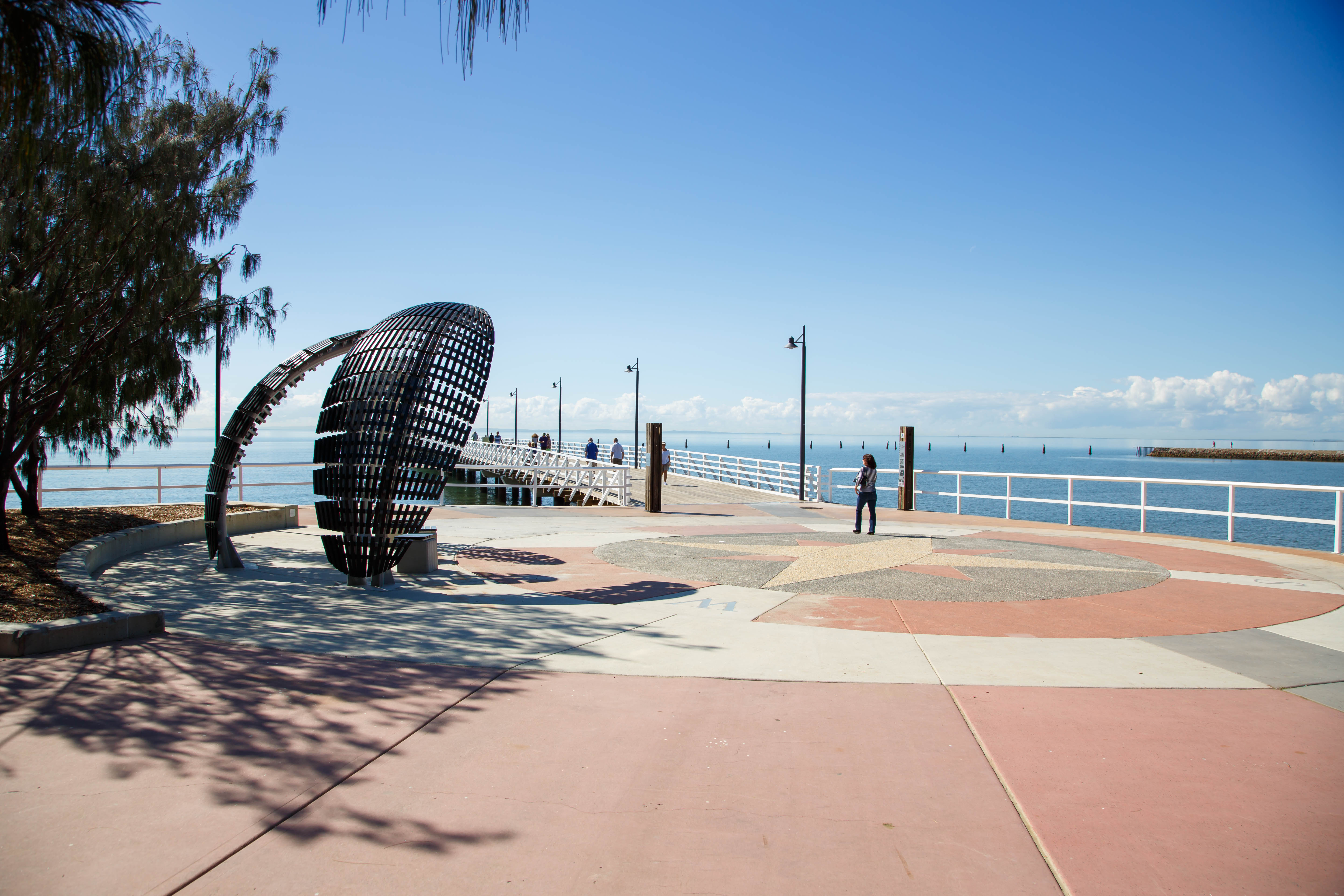
SANDGATE PIER
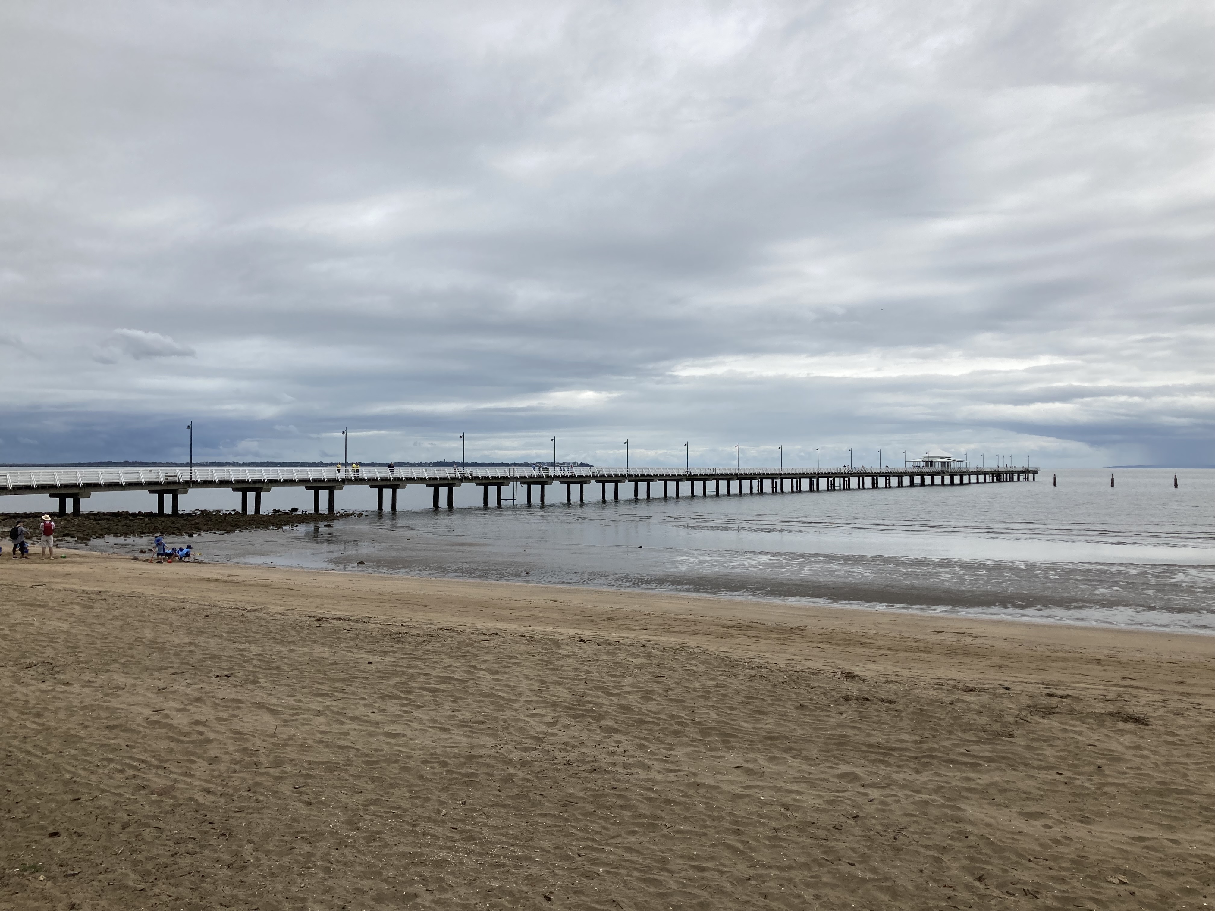
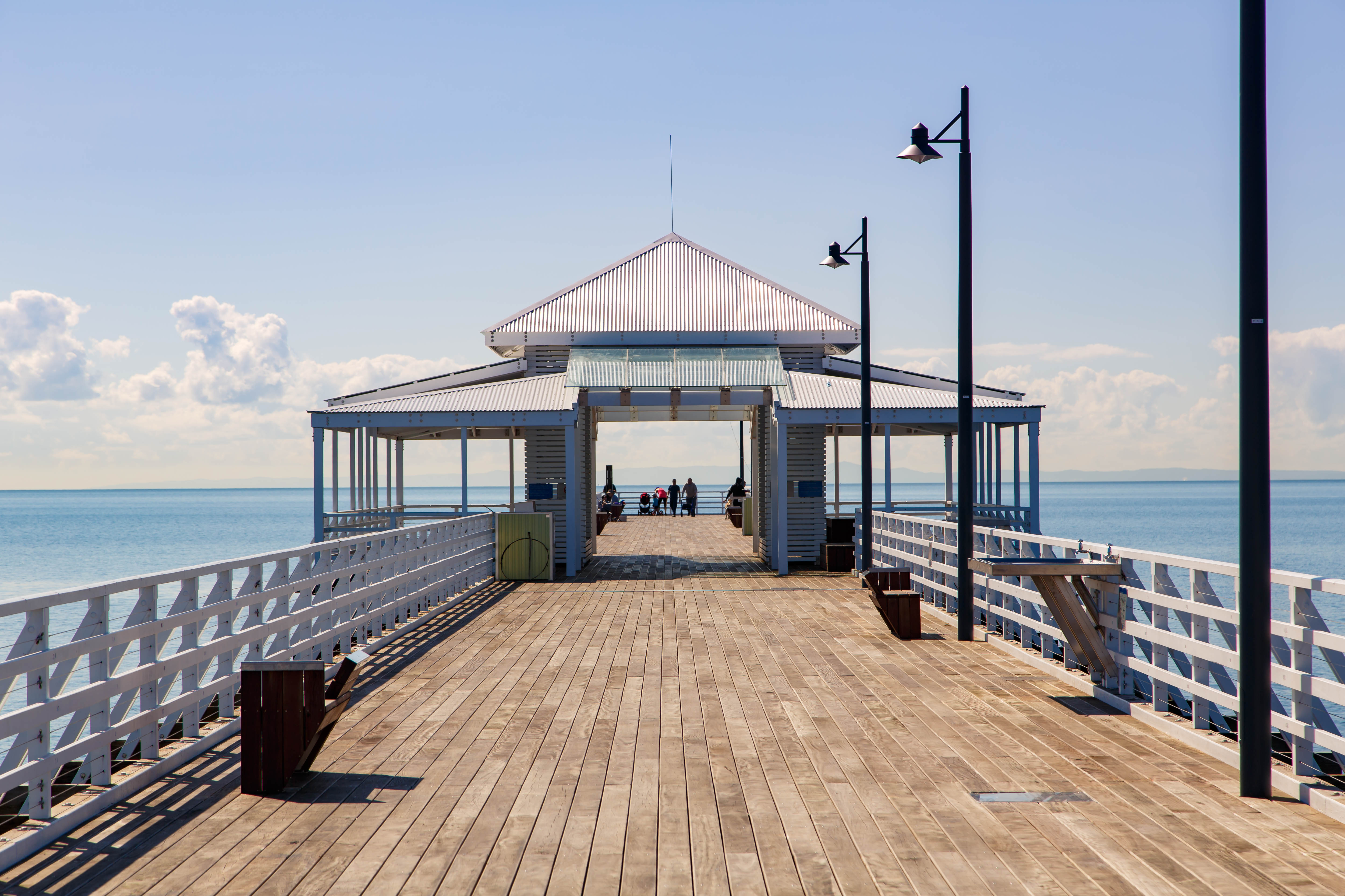
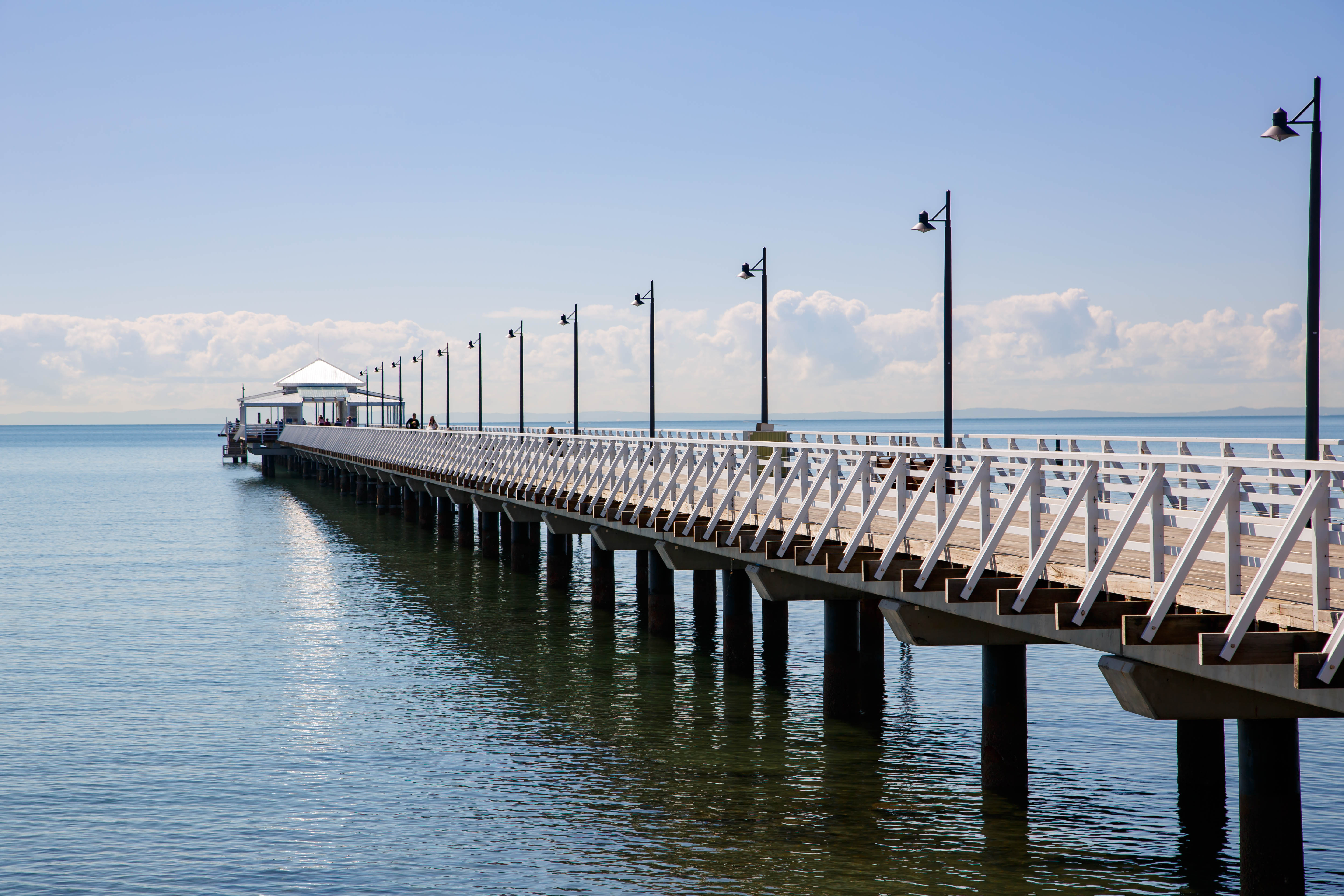
This 350m long pier became a lively promenade on weekends during Sandgate’s heyday as a seaside resort. Built as a business venture by the Sandgate Pier Company in 1882, the pier was never a successful investment for any of its owners. Prominent architect F.D.G. Stanley was called upon to design a 259m pier, bathing houses, caretaker’s cottage and swimming bath fencing. The investors hoped to capitalise on transporting passengers and cargo to Sandgate as well as using the pier as a place where visitors and locals could promenade, fish and bathe. The length of the pier proved inadequate as vessels were not able to tie up at the pier at low tide and the pier was subsequently extended another 91m. The Sandgate Pier Company was also involved in the operation of the Redcliffe and Steam Ferry Company, which ran vessels from the pier. This venture was short-lived and so too was the Sandgate Pier Company, which went into voluntary liquidation in 1888. Segregated baths were constructed to the shore line of the pier, the Ladies baths to the north and the Men’s baths to the south. A caretaker’s cottage was constructed to the north side. There was a small office and turnstiles to collect the fee charged for admission. The segregated bathing enclosures remained popular and various lessees ran vessels to the pier until 1928. The financial return from the operation was not high and finally the Sandgate Municipal Council obtained a loan to purchase and repair the pier in 1901. As an amusement and recreation venue, the pier was a great attraction on weekends and public holidays. The Brisbane Courier in 1923 reported “the pier, though quite inadequate, is one of the chief attractions, and is largely patronised by pedestrians and amateur fishermen”. In the 1930s an enclosed area protected by railway lines, shark net and stone wall was constructed as a shark-proof swimming enclosure which was lit at night. Adjacent to the pier were bathing sheds and an open-air picture area. Since 1955 the pier has been the starting point for the Brisbane to Gladstone yacht race, which was first sailed from Woody Point in 1949.
FLINDERS AVENUE KIOSK, SWIMMING BATHS, BATHING BOXES
An area along the foreshore between Fourth and Fifth Avenues was once the hub of the Sandgate seaside experience. It was lined with tiny bathing boxes and a kiosk dating from the early 20th century supplied the hundreds of holiday-makers with ices and other delights. The kiosk was similar to the Moora Park kiosk. Adjacent to the shore was a rest shed and a small jetty to give access across the rock retaining wall. An added attraction was the moving pictures shown on the outdoor movie screen. In the early 1930s the timber kiosk was demolished and replaced by a brick and stucco building with an enlarged Dining Room. At this time the seaside was experiencing a boom. Like other entertainment venues in Sandgate the kiosk fell on hard times and was closed in 1962 and soon after demolished.
The first swimming baths known as the segregated bathing facilities were erected to either side of the Pier. The Sandgate Amateur Swimming Club was founded in 1924 and members used the Men’s swimming enclosure on the south side of the Pier. These facilities were inadequate and new concrete swimming baths were built alongside the kiosk in Flinders Parade in 1927. They reflected the newly developed interest in swimming as a sport and healthy recreational activity. From the spectator gallery of the baths enthusiastic supporters cheered budding champions from the Sandgate Amateur Swimming Club and elsewhere. The success of local swimmers in competition, particularly Bill Flemming in the 1938 Empire Games, was attributed to the salt water which filled these baths. The baths were closed and demolished in the early 1970s and new baths erected further north along the foreshore in 1973.
LOVER’S WALK
By 1902 the Sandgate Town Council completed a walkway around the foreshores from the Baptist Church in Flinders Avenue to the mouth of Cabbage Tree Creek. The walk was built into the sheer cliff face, just above high water mark. Eroded by the action of the tidal waters in parts, the walk was difficult to maintain. Bathing sheds were built at various places along the walk by the Council.
SANDGATE BAPTIST CHURCH
The Baptist Church on the foreshore at the corner of Cliff Street and Flinders Parade was constructed in 1887 and has remained a focus for Baptist worship for over 100 years. Formal Baptist worship in the Sandgate area began in 1868 with Reverend Wilson preaching to local Baptists on the beach. The first Baptist chapel in Sandgate was built in Loudon Street in 1872. During the 1880s Sandgate experienced a residential boom, aided by the completion of the railway to Brisbane in 1882. The Sandgate Baptist congregation grew accordingly and planned for a new, larger church building. The church was designed by architect Richard Gailey, a prominent 19th architect who designed a number of other Baptist churches and major commercial buildings. The church was built by local builder William Street on land donated by Mr G. Phillips, a former Engineer of the Sandgate Town Council. Over the years the Church has been used by a number of local community organisations including as the venue of the first Masonic lodge in Sandgate from 1894 to 1920. Renovations were undertaken in 1928, 1945 and 1986.
BEACH THEATRE, 76 FLINDERS PARADE
The Beach Theatre, built in 1924 at 76 Flinders Parade, marked a period when Sandgate was booming as a seaside resort. New forms of popular entertainment were being added to the ongoing attractions of swimming and picnicking. Early forms of picture shows had been in the area from the late 19th century, playing in local halls, including the town hall. By the early 20th century open-air theatres could be found near the kiosks in Moora Park and Flinders Parade (then known as the Brighton Esplanade), as well as near the entrance to the Pier. The arrival of the “talkies” from the mid-1920s increased the popularity of going to the movies. In addition to the Beach, other new theatre buildings were constructed and by the end of the 1930s there were five theatres in the Sandgate area.
MERIDAN, 130 FLINDERS PARADE
Sandgate was Brisbane’s premier holiday resort with many rental properties, boarding houses, guesthouses and grand mansions of wealthy business men and politicians. Flinders Parade, formerly known as Brighton Esplanade, was a favoured position. With her husband Edward, a painter, Margaret Dyer lived in and ran the boarding house Meridan at 130 Flinders Parade from around 1907. The family was well-known for its interest in lawn bowls and established a private three-rink green near the house. Edward Dyer was involved in the formation of the Sandgate Bowls Club in 1914. As women players were not allowed to use the Club they played on the private green at Meridian instead.
Description
General
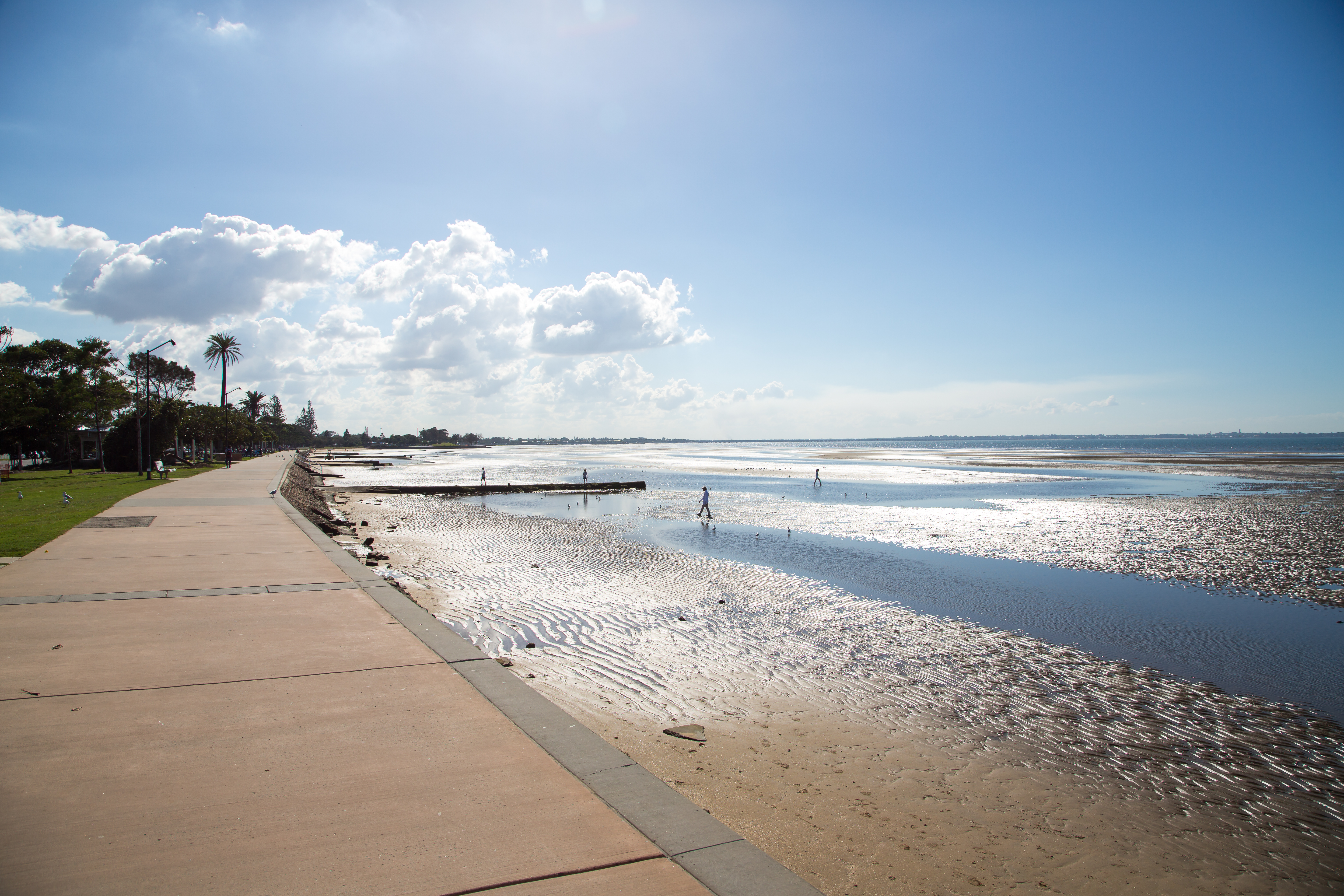
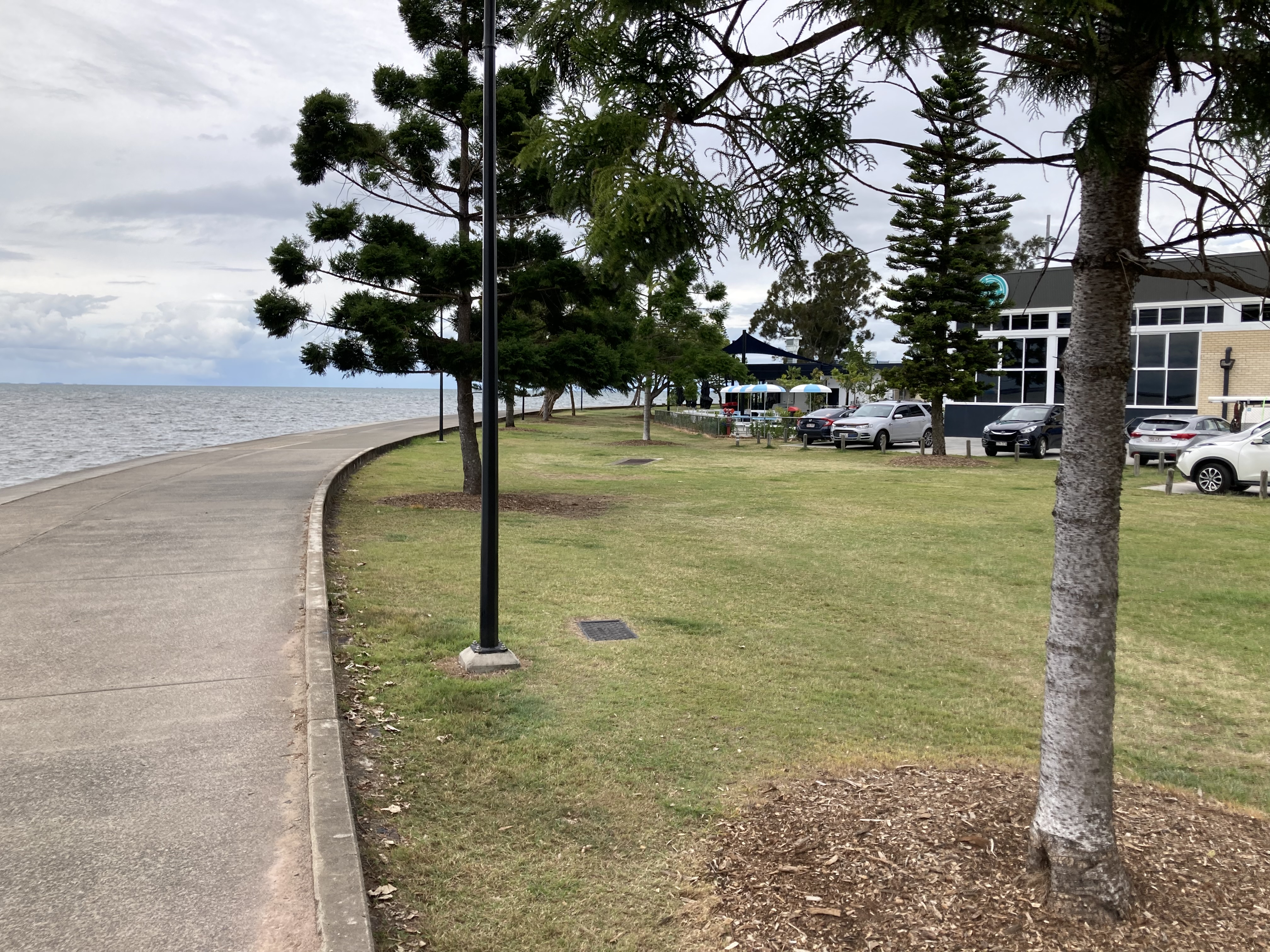
The Bramble Bay Foreshores comprise continuous publicly accessible parklands stretching for more than 7km along the foreshores of Bramble Bay. Starting from the northern shore of Cabbage Tree Creek, the foreshores encompass the treed bluffs of Shorncliffe (Cabbage Tree Head) before falling north towards the flat parkland adjoining Flinders Parade. This strip of parkland bulges opposite the end of Eighth Avenue to accommodate the Sandgate Swimming Pool and continues north past Brighton until it meets the Hornibrook Highway. All of the land adjoining the foreshores is Council-owned except for the land containing the Eventide retirement complex at Brighton. The foreshores afford extensive and fascinating views up and down the shoreline, across the Bay to Moreton and North Stradbroke Islands and to the Redcliffe peninsula. From the southern foreshores one can see as far north as the Glass House Mountains. From the northern foreshores the Port of Brisbane at Fishermans Island is visible. The water views from the heights of Shorncliffe are filtered through stands of eucalypts.
Sea Wall - generally
Much of the water’s edge is defined by stepped porphyry sea walls. The walls extend from Cabbage Tree Creek to the Hornibrook Highway Park, broken only by the rock
formations at the base of Cabbage Tree Head. The walls incorporate boat ramps and steps at various points.
Cabbage Tree Creek foreshore and parkland
An avenue of Moreton Bay Figs lines the parkland facing the mouth of Cabbage Tree Creek. The sea wall incorporates a public boat ramp. The pitch of the stepped wall changes as it approaches the Bay. A small timber pier, known as Baxter’s Jetty, projects into Cabbage Tree Creek. The eastern end of this area contains a carpark and public toilet block. Cabbage Tree Head The porphyry wall that lines Cabbage Tree Creek is terminated by the natural rock formations at the base of Cabbage Tree Head. An unpaved path leads along the base of the soft sandstone cliffs. The rockfaces reveal a great diversity of colours, formations and weathering patterns. Signage at the northern end of the headland reveals that the cliffs comprise triassic sedimentary rocks. A faultline is visible at the southern ends of the cliffs. The sign notes “course calstic rocks (conglomerate, breccia, grit) are found below the faultline while above, separated by carbonaceous shale, are two prominent sandstone beds”.
Moora Park foreshore
The area below Moora Park was the main bathing beach at Sandgate. The timbered slopes once provided the setting for a substantial A.H. Foster-designed kiosk and bathing pavilion. The slopes are criss-crossed by paths and driveways providing access to the flat area between the embankments and the sea. This flat area now contains paths and seating areas shaded by cotton trees. A painted brick flat-roofed toilet and changeroom complex building overlooks this area.
Shorncliffe Pier & groyne
The pier extends some 350m into Bramble Bay and together with the stonework groyne to its south, encloses a once popular swimming beach. The pier’s hardwood timber decking is supported on a timber sub-frame. This is supported on concrete and timber piers. A platform near the end of the pier is covered by a timber framed pavilion, incorporating picnic tables and seating. The hipped roof is sheeted in white Colorbond-finished corrugated iron. The pier and groyne once formed two sides of a shark protected swimming enclosure. The cage was formed by a combination of nets, closely spaced balusters made of railway track and the sea wall. Some panels of the railway track cage remain beneath the pier. A series of piles can still be seen between the pier and groyne, indicating the extent of the former enclosure. The groyne is constructed from roughly stepped stonework and capped with a concrete path about 400mm wide. The rusting remnants of the former shark enclosure projects from the end of the groyne.
Lovers Walk
This refers to the promenade between the pier and Cliff Street. It is bordered by vegetated embankments. Parkland between the road and the embankments is edged by a simple white painted post and rail timber fence. In parkland opposite the end of Signal Row there is a stone directional dial bearing the inscription “Sandgate Lions Club 1982”. The dial is mounted on a concrete plinth and surrounded by six iron bollards. These appear to pre-date the dial. The timber base of a former flagpole or similar structure remains embedded in the slab.
Parkland between Cliff Street and Eighth Avenue
The Baptist Church at the corner of Flinders Parade and Cliff Street marks the southern end of these flat open parklands. The sea wall continues north bordered by well tended lawns and stands of trees such as palms and pines. A brick public toilet block is located near the end of Third Avenue.
Various concrete drains and structures of unknown purpose extend from the sea wall at regular intervals. A pair of these are located opposite the ends of Fourth and Fifth Avenues and may be remnants of the Sandgate baths.
Swimming Pool
This complex of Olympic, children’s and indoor pools is built on a bulge of land reclaimed originally for the construction of the wading pool. The pools were designed in 1972.
Parkland between Eighth Avenue and Hornibrook Highway
The parkland continues as an open ribbon of lawns and paths. As with the area south of the swimming pool, there are numerous structures jutting out into the mudflats from the sea wall. Between Fifteenth and Sixteenth Avenue a small timber bridge carries the promenade across a drain outlet.
The northern end of Flinders Parade is terminated by the Eventide complex, however public pedestrian access to the waterfront is maintained through or in front of Eventide. The waterfront parkland resumes on the northern side of Eventide and continues to the Hornibrook Highway.
Statement of significance
Relevant assessment criteria
This is a place of local heritage significance and meets one or more of the local heritage criteria under the Heritage planning scheme policy of the Brisbane City Plan 2014. It is significant because:
References
-
Brisbane City Council Heritage Unit, Bramble Bay Foreshores Conservation Management Study, Site Report, September 2002
Citation prepared by — Brisbane City Council (page revised October 2022)