Addresses
Type of place
House, Hospital
Period
Federation 1890-1914
Style
Queenslander
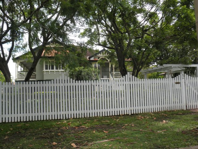

This is an image of the local heritage place known as Residence
22 Ettie Street, Sherwood
Addresses
Type of place
House, Hospital
Period
Federation 1890-1914
Style
Queenslander
This large Federation styled house was built in 1914 for William and Estella Morrison. From 1921 to 1927 it served as the Sherwood Private Hospital and was the birth place of a number of the district's residents. The house was sited on a large block and, typical of the pattern of residential development in the Sherwood district, this was very slowly subdivided in subsequent years.
Also known as
Mayfield
Lot plan
L2_RP46144
Key dates
Local Heritage Place Since —
Date of Citation —
Construction
Roof: Terracotta tile;Walls: Timber
Criterion for listing
(A) Historical; (A) Historical; (E) AestheticInteractive mapping
Also known as
Mayfield
Lot plan
L2_RP46144
Key dates
Local Heritage Place Since —
Date of Citation —
Construction
Roof: Terracotta tile;Walls: Timber
Criterion for listing
(A) Historical; (A) Historical; (E) AestheticInteractive mapping
History
The area from Chelmer to Corinda was known as “Boyland’s Pocket” in the 1850s, Captain Boyland having leased the area in 1851. In 1860 the new Queensland Government opened up the district for selection, at a price of 1 pound per acre, resulting in the establishment of a number of farms ranging anywhere between 25 and 70 acres in size. Attempts were made by pioneer selectors during the 1860s and 1870s to produce maize, potatoes, bananas, cotton, sugar cane, and arrowroot. The opening of a railway bridge at Indooroopilly in 1876 reduced the isolation of the area, and allowed for increased subdivision. Sherwood had felt its first developments in the 1870s, with churches, a post office, local store and an Orange Lodge Hall constructed, and the first main building wave followed in the 1880s, a boom period for Brisbane. However, many of the allotments sold at this time remained vacant for years, and continued to be used for small farming operations. Later waves of building, occurring after each of the World Wars, gradually reduced the amount of farmland, and new housing continues to envelop those gracious older houses which once stood on acreage, surrounded by gardens. By 1921 Sherwood was an established residential suburb with a population of nearly 1,300 by 1921.
Sarah Jane Seeney, wife of Stewart Seeney, purchased the 2 roods and 5.1 perches on which the house was built in August 1913, taking out a mortgage for £800 the next month. In November 1914 she purchased the neighbouring 3 roods and 14 perches, taking out a mortgage for £275 in December. As ‘head of the household’, Stewart Seeney is listed as living in Sherwood between 1914 and 1916.
Seeny’s original holding was sold to William Morison in February 1915, and by October 1915 electoral rolls listed Morison, his wife Estella and Estella’s brother, Reginald Viles, as living in ‘Mayfield’ in Ettie Street, Sherwood. The Morisons had moved to Queensland from New South Wales, living in South Brisbane and Hamilton before their purchase of the Sherwood property. Morison was a commercial agent, and is likely to have had some link to the firm of commission agents and produce merchants, Morison Brothers, which had offices in Roma and Turbot Streets, Brisbane.
The Morisons lived in ‘Mayfield’ from 1915 to 1921, suffering the death of their eleven-year-old son, William Nevin, at the property in 1918. In January 1921, William Morison sold his furniture, explaining that he was removing to another State. He retained ownership of the Sherwood property, however, and expanded it in December of that year, purchasing adjoining lots which had been part of Seeney’s 1914 purchase.
It appears that the property was used as the Sherwood Private Hospital shortly after the Morisons moved. Notices placed in the Brisbane Courier announce the births and deaths of residents of surrounding suburbs at the Sherwood Private Hospital from 1921, although the hospital was not listed in Post Office Directories until 1926. ‘Mayfield’ was used as a hospital until 1927, when matrons Agnes and Katherine McKeon purchased ‘Dunalister’ in Lilly Street and relocated the hospital there.
William Morison died in 1926 and the property was transferred to the Queensland Trustees. It was offered for auction in October 1927. The property was large, with eight alloments totalling 3 roods and 32.1 perches, and was described as being situated ‘in a select part of this healthy suburb’, near the railway station and on level ground. The substantial building on the property, also known as the Mayfield Private Hospital, contained five bedrooms as well as large drawing and dining rooms, and three 8-foot verandahs. However, it appears that the property was not sold at the auction.
Another sale of the house and a number of the allotments was attempted in 1929, including the 1 rood and 17 perches on which ‘Mayfield’ was situated. Charles Henry Pickard bought the 78.15 perches containing the house in 1931. Pickard died in 1934 and the land was transferred to Elizabeth Finley Cock, wife of John Saunders Cock.
A subdivision of twenty-one perches at the rear of the property was sold in 1941 and the remainder transferred to City Investments Limited in 1942. Michael and Eva Real bought the house and the 57.15 perches of land from City Investments in 1950 and converted it to a registered boarding house / tenement. It remained registered as such until mid-1956. George Cain and John Hallam bought the property in early 1956 and sold it to John and Patricia Ritch in 1975. Subsequent to two intervening ownerships, the current owners purchased the property in December 2004.
Statement of significance
Relevant assessment criteria
This is a place of local heritage significance and meets one or more of the local heritage criteria under the Heritage planning scheme policy of the Brisbane City Plan 2014. It is significant because:
References
-
Brisbane City Council, 1946, 2001 & 2005 aerial photographs
-
Walter Taylor South Character and Heritage Study, BCC Heritage Unit, 1997
-
Brisbane City Council Water Supply and Sewerage Detail Plans
-
McKellar's Map of Brisbane and Suburbs. Brisbane: Surveyor-General’s Office, 1895
-
Department of Natural Resources and Mines, Queensland Certificates of Title
-
Queensland Post Office Directories
-
The Brisbane Courier 1927
-
University of Queensland, ‘Queensland Places: Sherwood’ (http://queenslandplaces.com.au/sherwood) accessed 22 July 2010
Citation prepared by — Brisbane City Council (page revised June 2022)