Addresses
Type of place
House, Farm
Period
Federation 1890-1914
Style
Queenslander
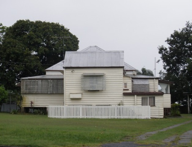

This is an image of the local heritage place known as Residence
31 Linda Street, Sherwood
Addresses
Type of place
House, Farm
Period
Federation 1890-1914
Style
Queenslander
This former farmhouse is believed to have been built some time before 1890 for George Jimmieson. Jimmieson had worked land in the district 1866. The house later passed to two other local farming families, the Martindales and the Nosworthys. The house still sits on its original 1890 subdivision and survives as a good example of a late nineteenth century farmhouse.
Lot plan
L13_RP82792; L14_RP82792
Key dates
Local Heritage Place Since —
Date of Citation —
Construction
Roof: Corrugated iron;Walls: Timber
People/associations
Jimmiesons (Occupant);Martindales (Occupant);
Nosworthys (Occupant)
Criterion for listing
(A) Historical; (H) Historical associationInteractive mapping
History
The area from Chelmer to Corinda was known as “Boyland’s Pocket” in the 1850s, Captain Boyland having leased the area in 1851. In 1860 the new Queensland government opened up the district for selection, at a price of 1 pound per acre, resulting in the establishment of a number of farms ranging anywhere between 25 and 70 acres in size. Attempts were made by pioneer selectors during the 1860s and 1870s to produce maize, potatoes, bananas, cotton, sugar cane, and arrowroot. The opening of a railway bridge at Indooroopilly in 1876 reduced the isolation of the area, and allowed for increased subdivision. The first main wave occurred in the 1880s, a boom period for Brisbane. However, many of the allotments sold at this time remained vacant for years, and continued to be used for small farming operations. Later waves of building, occurring after each of the World Wars, gradually reduced the amount of farmland, and new housing continues to envelop those gracious older houses which once stood on acreage, surrounded by gardens.
In April 1889 George Theodore Bell, auctioneer, purchased 11 acres and 30 perches of land in portion 92 from George Jimmieson, who had farmed the 25 acre portion since 1866. Jimmieson also owned portion 118. Bell never lived in the area, and the house at 31 Linda St is marked on the estate map in November 1890 that advertised subdivisions for sale in “Sherwood Heights”, which would indicate that the house was built by Jimmieson, and was possibly the farmhouse for portion 92.
In November 1890 Daniel Murcott purchased the Linda St property of 38.6 perches from Bell, but Murcott is never listed in the POD or QER for the district.
Julia Elizabeth Martindale (nee Nosworthy), wife of Charles Clewley Martindale (married 1865), purchased the house in 1896. She appears to have been the daughter of Robert and Betsy Nosworthy, who had immigrated from Devon to Queensland with three children in the early 1860s, and who farmed on portions 113 and 114 alongside Oxley Creek. Nosworthy Park, Corinda, is where their homestead was.
C.C. Martindale farmed on portion 98, and his property is remembered through Clewley and Martindale streets, Corinda. He took title at 31 Linda St when Julia Elizabeth Martindale died in 1901. In 1902 the house was transferred to Julia Margaret Nosworthy, Julia Elizabeth’s younger sister, who was a popular Sunday School teacher in Sherwood during the 1920s and 1930s. Julia Margaret Nosworthy sold the house to Alfred and Florence May in 1928, and died in 1942. She is buried with her parents Robert and Betsy in the Sherwood Anglican cemetery.
The property was sold to the Brandes family in 1946, and remains in their hands. In 1958, 1.4 perches was resumed for the railway, but the property remains essentially as it was when the “Sherwood Heights” estate was advertised in 1890.
Statement of significance
Relevant assessment criteria
This is a place of local heritage significance and meets one or more of the local heritage criteria under the Heritage planning scheme policy of the Brisbane City Plan 2014. It is significant because:
References
-
Title deeds, Department of Natural Resources and Mines
-
Walter Taylor South Character and Heritage Study, BCC Heritage Unit, 1997
-
Queensland Post Office Directories
-
Queensland Electoral Rolls
-
Brisbane City Council Water Supply and Sewerage Detail Plans
-
Surveyor-General’s Office. McKellar’s Official Map of Brisbane and Suburbs. Brisbane, 1895
-
Queensland Pioneers Index 1829-1889. Births, Deaths and Marriages
-
Anglican Church of Australasia, Parish of Sherwood, (Brisbane), Cemetery and Columbarium Wall, Monumental Inscriptions
-
Rosemary and Eric Kopittke, Queensland Family History Society. 1995. Them’s Our Ways in Oxley-Chelmer. Oxley-Chelmer History Group Papers III, Ralph Fones, Ed. 1999-2000
-
Settler’s Tales, Oxley Creek Times. www.brisbane-stories.powerup.com.au
Citation prepared by — Brisbane City Council (page revised June 2022)