Addresses
Type of place
Cottage, House
Period
Victorian 1860-1890
Style
Queenslander
Addresses
Type of place
Cottage, House
Period
Victorian 1860-1890
Style
Queenslander
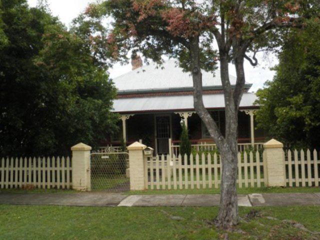
This nineteenth century brick cottage was likely to have been built between 1887 and 1889. It is significant as a rare, surviving, early brick cottage completed at a time when the Sherwood district was mainly farmland.
Lot plan
L1_GTP2806
Key dates
Local Heritage Place Since —
Date of Citation —
Construction
Roof: Corrugated iron;Walls: Face brick
Criterion for listing
(A) Historical; (B) RarityInteractive mapping
Lot plan
L1_GTP2806
Key dates
Local Heritage Place Since —
Date of Citation —
Construction
Roof: Corrugated iron;Walls: Face brick
Criterion for listing
(A) Historical; (B) RarityInteractive mapping
History
This brick cottage at Sherwood was probably built between 1887 and 1889.
The area from Chelmer to Corinda was known as “Boyland’s Pocket” in the 1850s, Captain Boyland having leased the area in 1851. In 1860 the new Queensland government opened up the district for selection, at a price of 1 pound per acre, resulting in the establishment of a number of farms ranging anywhere between 25 and 70 acres in size. Attempts were made by pioneer selectors during the 1860s and 1870s to produce maize, potatoes, bananas, cotton, sugar cane, and arrowroot. The opening of a railway bridge at Indooroopilly in 1876 reduced the isolation of the area, and allowed for increased subdivision. The first main wave occurred in the 1880s, a boom period for Brisbane. However, many of the allotments sold at this time remained vacant for years, and continued to be used for small farming operations. Later waves of building, occurring after each of the World Wars, gradually reduced the amount of farmland, and new housing continues to envelop those gracious older houses which once stood on acreage, surrounded by gardens.
George Jimmieson purchased the 25 acres of Potion 92 in 1866, and began subdivision about 1886, selling 1 rood of this land to Albert Edward Appleton in 1887. Appleton took out a mortgage for 200 pounds in 1887, and one for 50 pounds in 1888. The only Alfred E. Appleton listed in the POD around this time is a Ladies Outfitter in Melbourne St South Brisbane (alphabetical POD 1892-93), but an E. Appleton is listed as a labourer in Sherwood in 1892, and as a contactor at Sherwood in the 1892-93 POD. He is not listed in the 1893 POD. Neither Appleton is listed in the Oxley Electoral Roll before 1900.
Local Historian Ralph Fones claims that an Alfred E. Appleton started the first manufacturing industry in Sherwood in 1908, with a sheetmetal and lamp factory on the corner of Sherwood Rd and Jerrold St, next to his house. This Appleton invented, among other things, a railway guard’s signal lamp that could change colour from red to green, with ceramic burner tips. “Appleton Traffic Equipment Pty” was still trading in Darra in 1995.
In 1888 the land was sold to John Neale, who was listed in the POD as living in Sherwood from 1889. In the 1895 Electoral Roll he is listed as having freehold at subdivision 15, portion 92, which is 2 sections to the south of the house at 1/46 Primrose. In 1917 Neale sold the property to the Hennessy family, which held it until 1981. In 1991 the property was subdivided, and a 2 story duplex was built to the rear of the cottage.
The cottage at 1/46 Primrose could have been built by Appleton in 1887-1888, or by Neale in 1888-1889. The house itself appears to have been in continuous use since completion. Its brick construction is uncommon for Sherwood and it remains a fairly intact example of its type. There is no evidence that the house was ever associated with a farm making this one of the earlier purely residential sites in Sherwood.
Statement of significance
Relevant assessment criteria
This is a place of local heritage significance and meets one or more of the local heritage criteria under the Heritage planning scheme policy of the Brisbane City Plan 2014. It is significant because:
References
-
Title deeds, Department of Natural Resources and Mines
-
Walter Taylor South Character and Heritage Study, BCC Heritage Unit, 1997
-
Queensland Post Office Directories
-
Queensland Electoral Rolls
-
Brisbane City Council Water Supply and Sewerage Detail Plans
-
McKellar's Map of Brisbane and Suburbs. Brisbane: Surveyor-General’s Office, 1895
-
Queensland Pioneers Index 1829-1889. Births, Deaths and Marriages
-
Them’s Our Ways in Oxley-Chelmer, Ralph Fones, 1995
Citation prepared by — Brisbane City Council (page revised June 2022)

