Addresses
Type of place
Bridge, Reserve
Period
Federation 1890-1914
Style
Free Classical

This is an image of the local heritage place known as Walton Bridge & Reserve
This is an image of the local heritage place known as Walton Bridge & Reserve
Walton Bridge & Reserve
Addresses
Type of place
Bridge, Reserve
Period
Federation 1890-1914
Style
Free Classical
Walton Bridge demonstrates, in its scale and design, the importance of road communications between the city and Enoggera Reservoir in the late 19th and early 20th centuries. It is an important and substantial turn of the century remnant of municipal engineering undertaken by the then local authority, the Enoggera Divisional Board, in conjunction with the State Government. The bridge is intimately connected with the social history of Waterworks Road and the development of The Gap. The Reserve in the immediate vicinity of the Bridge has archaeological significance as the location of indigenous artefacts and the 1860s cast iron pipeline from Enoggera Reservoir to the city. Set amidst verdant parkland, the bridge’s robust arches frame the progress of Enoggera Creek, creating a haven from the road traffic above.
Lot plan
L970_CP896856
Key dates
Local Heritage Place Since —
Date of Citation —
Construction
StructureCriterion for listing
(A) Historical; (C) Scientific; (E) AestheticInteractive mapping
Lot plan
L970_CP896856
Key dates
Local Heritage Place Since —
Date of Citation —
Construction
StructureCriterion for listing
(A) Historical; (C) Scientific; (E) AestheticInteractive mapping
History
The thoroughfare now known as Waterworks Road was established as a track to Enoggera Reservoir, the first dam erected in Queensland and only the second in Australia. The track also serviced the scattered Enoggera diggings in the hills behind the Reservoir. The dam was completed in 1866. A cast iron pipeline was laid from the Reservoir to the service reservoirs on Wickham Terrace. The pipeline was utilised in Brisbane’s reticulated system until 1910. The original pipeline intersects Waterworks Road at a number of points, one of which is at Walton Bridge.
By the 1890s, the Reservoir had become a popular destination for picnics.1 Traffic increased on Waterworks Road and tramlines were extended into the Red Hill area between 1897-1904. The tram line was extended from Red Hill to a terminus near Oleander Drive, Ashgrove in 1924.
For many years the track to the Waterworks was the only main road in The Gap area. A timber bridge was built at the Enoggera Creek crossing near “Walton”, the residence of Jesse Paton, an early pioneer in The Gap area. The grand house reputedly took the name of the family’s place of origin in England. The timber bridge was destroyed by the floods of 1893 and replaced by the present concrete arched structure in 1900. The bridge was officially opened on 30th April of that year.
(The bridge) was built, probably at considerable expense, at a scale and strength to resist floodwaters. Given the absence of a residential population in The Gap at this time, the bridge’s dimensions indicate the importance placed upon access to the waterworks for maintenance purposes during this period.2
The grandeur of the opening ceremony of Walton Bridge indicates the significance and impact that this bridge had upon the Enoggera district. A luncheon was served and a number of important local and state dignitaries attended the opening. These included the members of the Enoggera Divisional Board, the Hon. J. Murray M.L.A., Minister for Works, Hon. A. Rutledge M.L.A. Attorney General, and Hon. J.G. Drake M.L.C. Minister for Public Instruction & Postmaster General. The Moreton Mail recorded:
… that the bridge, as a structure, is worthy of the formalities, for it is admirable of design and equally admirable in execution3
The bridge was constructed by a Mr Macdonald at considerable cost to the small Enoggera Divisional Board. It was however partly offset by a State Government grant of £600. The balance of £1500 was borrowed by the Board.
The significance of the bridge to the community has been expressed in a number of ways and at different periods. During 1946, the musician Elizabeth Blair and her husband stayed at the nearby Paten home. Apparently she was “captivated by the bridge and committed her feelings to piano in a piece of music called, appropriately, “Walton Bridge“…”4
The open space and scenic bridge setting that currently prevail at Walton Bridge can be approximately dated to the early 1970s. Local historian Richard Speechly remembers a landscaping effort at this time:
The Walton Bridge Reserve was not as large an area (in the Post War decades) as it is now. Clearing the scrub … was the result of a works initiative in 1974, of the new Whitlam government ...5
In 1998 as part of investigations for the proposed widening of Waterworks Road, Brisbane City Council commissioned a cultural heritage analysis from Ann Wallin & Associates. Walton Bridge was part of Precinct 20 in that report and was assessed as being of “major heritage significance” (p.1) - rated as “high” for historic value, aesthetic value, scientific value and integrity and “medium” for representative value (p.58). (The study notes that these were based on brief assessments and that “heritage levels may require defining in further drafts” (p.51))6
To celebrate the centenary of the bridge residents and dignitaries attended a function at the bridge on 6th May, 2000. A plaque was placed on the bridge, at a height suitable to discourage vandalism. The plaque stated the following:
Walton Bridge
1900-2000
Bridging Cultures
Bridging Communities
Bridging Generations
Dedicated on May 6, 2000
By the
Ashgrove-The Gap
Heritage Association.
In January 2000, the Transport & Structures section of City Design presented 9 options for the development of a new bridge parallel to Walton Bridge. Works commenced on the new bridge in October 2001 and are expected to be completed in May 2002.
Description
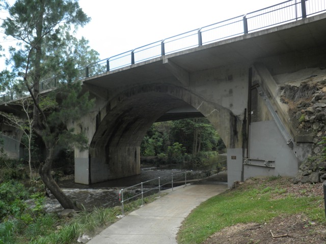
The robust concrete arches of Walton Bridge carry Waterworks Road over a gully formed by Enoggera Creek. A series of reserves follows the creek, encompassing sporting fields and clubhouses to the south of the bridge and playgrounds and passive recreation areas to the north.
At the time of writing this report the site was subject to major roadworks associated with the widening of Waterworks Road. A new road bridge was being constructed parallel to the existing bridge, to its immediate south. The bridge’s existing cantilevered footway is to be removed and replaced with a similar structure on the north side of the bridge.
The scope of this site report is to examine the bridge itself and the reserve areas adjacent to the bridge. It does not examine the parkland containing the sporting clubs, nor the areas north of the junctions of Fish and Enoggera Creeks. This report did not assess areas of potential archaeological significance in the Walton Bridge Reserve, as identified in the cultural heritage analysis prepared for the widening of Waterworks Road 1. Instead, the report summarises the findings of the archaeological consultants employed to monitor the works, and generally endorses their recommendations.
Walton Bridge
Walton Bridge is a poured concrete structure supporting a superstructure of roadway and adjoining footpath. The footpath overhangs the southern side of the bridge, supported by cantilevered concrete beams. The bridge features 2 spans formed by segmental arches. These spring from concrete abutments and a central pier. The profile of the central pier features an angle against the flow of the creek, providing a buttressing and diverting effect during times of heavy water flow.1 Beneath the western arch, a small concrete causeway diagonally crosses the creek. A concrete pedestrian and bicycle path has been built beside the western abutment.
The approaches to the abutments are retained by a number of freestone walls. The arches, spandrels, abutments and piers are unadorned, and the bridge’s rudimentary forms are emphasised by the unpainted rendered finish. The line of the extrados, or top of the arches remains visible, perhaps indicating that the arches were formed and poured before the spandrels. The handrail is formed by a simple galvanised pipe post and rail with a chain wire mesh infill.
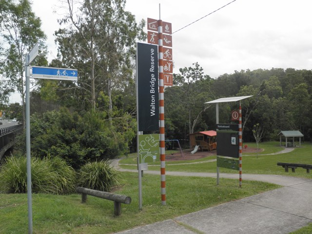
The reserve
The reserve on the south side was, at the time of writing this report, largely occupied by the site works for the new road bridge. The north side parkland features undulating grassed and treed areas, falling towards Enoggera and Fish Creeks. These areas contain children’s play facilities, picnic areas, a timber pedestrian bridge crossing the creek and a monument to the Aboriginal writer Rita Huggins (1921-96). The monument comprises a simple bronze plaque fixed to a granite boulder.
The cultural heritage analysis of the area identified the reserve area around the bridge as being of potential archaeological significance. This significance relates to the discovery of an indigenous stone item in 1998, and the probability of unearthing the original 1860s cast iron pipeline carrying water from Enoggera Reservoir to the city. In accordance with the recommendations in that report, subsequent works on the site have been monitored by an archaeological consultant, ARCHAEO. This is to minimise damage to sites and items of potential significance, assess the significance of any such item found and make recommendations for their future protection. ARCHAEO established, through monitoring of soil profiles as the works proceeded, that the stone indigenous artefact found in 1998 was likely to have been found in context (that is, not imported in fill material used in previous works). With respect to the 1860s pipeline, ARCHAEO confirmed that the pipeline did traverse Walton Bridge Reserve. Although damaged during excavations for the new bridge, ARCHAEO reported:
The sections of the pipe retained within the profile of the trench walls were photographed and recorded. The construction crew then set aside two sections of the pipe to be removed as samples. These have been retained by ARCHAEO, until permanent housing for them is arranged.1
The lower sections of the bridge piers are subject to graffiti attacks. Fissures have developed in the concrete surface of the spandrels, allowing ferns, grasses and small trees to take root in the structure.
The new adjacent bridge will affect views of the southern side of Walton Bridge. However the designers have opted for a contemporary framed structure to minimise visual obstruction of the old bridge. The slender tapering steel supports to the new bridge have been designed as a deliberate contrast to the original’s concrete arches and have been positioned so as not obscure the silhouette of the old bridge and to allow the principal views through the bridge to be framed by the old arches. From the northern side the new bridge will be screened by the old. A new walkway will project from the northern side, echoing the design of the southern walkway that is to be removed.
Statement of significance
Relevant assessment criteria
This is a place of local heritage significance and meets one or more of the local heritage criteria under the Heritage planning scheme policy of the Brisbane City Plan 2014. It is significant because:
References
-
Wallin 1998 p.12
-
Wallin 1998, p.16
-
Paton 2000, p.10
-
Paten, p.2
-
ARCHEO 2000 p.7
-
Wallin 1998, p.1, p.58, p.51
-
Ann Wallin & Associates, 1998
-
ARCHEO p.8
-
ARCHAEO 2001, p. 4
-
Brisbane City Council - City Assets Branch Conservation Management Study Stage 1 Report. November 2002
Citation prepared by — Brisbane City Council (page revised September 2020)