Addresses
Type of place
Roadway
Period
World War I 1914-1918


Unidentified photographer, 'High Street, Toowong, Brisbane, Queensland, ca. 1917', John Oxley Library, State Library of Queensland.
Patterson's Folly
Addresses
Type of place
Roadway
Period
World War I 1914-1918
Constructed prior to 1917, this median strip derives its name from the actions of notable Toowong local business identity and politician Charles Patterson. He proposed that the median strip be constructed, but the exact reason for this remains a matter of conjecture. The median strip is an important and visual remnant of the Toowong Shire period.
Geolocation
-27.48697 152.991142
Key dates
Local Heritage Place Since —
Date of Citation —
People/associations
Charles Patterson (Association)Criterion for listing
(A) Historical; (F) Technical; (H) Historical associationInteractive mapping
Geolocation
-27.48697 152.991142
Key dates
Local Heritage Place Since —
Date of Citation —
People/associations
Charles Patterson (Association)Criterion for listing
(A) Historical; (F) Technical; (H) Historical associationInteractive mapping
History
Understanding the importance of this median strip has two interrelated elements; the initial reasons why it was constructed; and secondly, why the colloquial name became attached to it.
The origins and justification of this median strip has a been the centre of controversy at the Toowong business centre for a number of years. In 1974 it was explained that,
During [Charles Patterson’s] term of office [as a member of the Toowong Council] he had envisaged a main road going through Toowong to Ipswich and he had actually started a four lane highway up High Street with grass and palm trees up the centre.
The High Street linked with Moggill Road, an important route to Ipswich via Moggill (crossing the river to Riverview), and also via the ‘Butcher’s Track’ to Sheehan’s Flat (Anstead) and Mount Crosby. Here the road crossed the river at Colleges Crossing to head towards Ipswich, or continued along the northern banks of the river towards the Burnett District.
In 1922 (as discussed in the Daily Mail) a few years after it was built, the median strip was held to have aesthetic merits and was symbolic of the progress of the Shire,
Down each side about 23ft in width, and the whole thoroughfare is a monument of municipal progress, and an example to the other parts of the city of Brisbane.
Scot Charles Patterson, the man after whom this median strip was named, arrived in Brisbane in 1871. Four years later, in partnership with D.McNicol and John Patterson, he built the Bon Accord Sawmill at Brookfield. The business prospered to the extent that, in 1884, Charles built an additional sawmill at Toowong. He became a member of the Indooroopilly Divisional Board and Toowong Shire Council, serving as Toowong’s first Mayor. Patterson performed many other roles within the local community and in the wider Brisbane sphere. They included service as a member of the committee (and later life governor) of the Children’s Hospital, Chairman of the Toowong State School committee, foundation member of the Toowong Bowling Club, and President of the
Toowong Horticultural Society
Construction date of the median strip can be placed at prior to 1917. A photograph dated from this time clearly discloses a fenced, completed median strip with small trees planted along the centre. (It should be noted that, understandably, the strip has altered in appearance since it was first constructed).
In 1965 Patterson’s son George claimed that the reason his father had the median strip built was to minimise the upkeep of the wide street. In a subsequent local election, an opposing candidate made an issue of the ‘potential danger’ posed by the median strip.
It is highly probable that the median strip had the intention of attempting to reduce road maintenance while providing an aesthetic asset to High Street. A view is that the median strip failed to cut down on road maintenance and in fact added to the costs of the area in upkeep. This fact could be combined with the reality, that the median strip is located in the centre of a wide street, which is lined on both sides by commercial premises. This would mean that in order to cross the street to carry out your shopping and business, you would frustratingly have to circumnavigate the median strip. These facts singular or combined may have led to the origin of its name.
Description
A raised garden bed median strip extending for most of the length of Toowong High Street. Dimensions - approx. 6 metres wide. Stone edging. Types of plants - mainly palms, poincianas, and grassed. It has experienced some changes over time but retains enough of its original character to be considered reasonably intact. This feature of Toowong High Street, Toowong’s traditional shopping precinct, gives this streetscape a memorable character.
Statement of significance
Relevant assessment criteria
This is a place of local heritage significance and meets one or more of the local heritage criteria under the Heritage planning scheme policy of the Brisbane City Plan 2014. It is significant because:
Supporting images
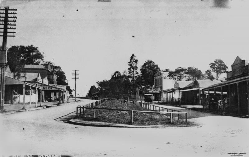
Unidentified photographer,
'High Street, Toowong, Brisbane, Queensland, ca. 1917',
John Oxley Library, State Library of Queensland.
Photograph of High Street, Toowong, looking southwest from the intersection with Sherwood Road, with St. Thomas Church of England, erected in 1877, in the distance. M. Carver, draper (on the right), was established in High Street around 1884 and continued in business until around 1951. F. W. Simmonds, chemist (on the left), was in business in High Street from around 1891 to around 1923. The photograph may be approximately dated by the fact that J. Cameron's bakery (on the left) only operated in High Street from 1917 to 1918. (Description supplied with photograph, with information sourced from Queensland Post Office Directories and Brisbane Telephone Directories)
References
-
Brisbane City Council Water Supply and Sewerage Detail Plans
-
Brisbane City Council Town Planning Branch, Toowong Business Centre: Improvements - Public display plan, April 1984
-
Department of Natural Resources, Queensland Certificates of Title and other records, Environmental Protection Agency
-
JOL Estate Map Collection and photographic collection
-
Lawson, Ronald Brisbane in the 1890s: A Study of an Australian Urban Society. St Lucia U of Q Press, 1973
-
Surveyor-General’s Office. McKellar’s Official Map of Brisbane and Suburbs. Brisbane, 1895
-
Nissen, Judith, 'Creating the landscape: A history of settlement and land use in Mount Crosby' School of History, Philosophy, Religion and Classics, University of Queensland (1999)
-
Smout, Arthur H. (ed.), 1824-1974 Brisbane Sesqui-Centenary Official Souvenir Book, Brisbane City Council , 1974, p. 24
-
Telegraph, 13 February 1965, p. 6
-
Watson, Donald and Judith McKay. Queensland Architects of the 19th Century: A Biographical Dictionary. Brisbane: Queensland Museum, 1994
Citation prepared by — Brisbane City Council (page revised September 2020)