Addresses
Type of place
House
Period
World War I 1914-1918
Style
Queenslander
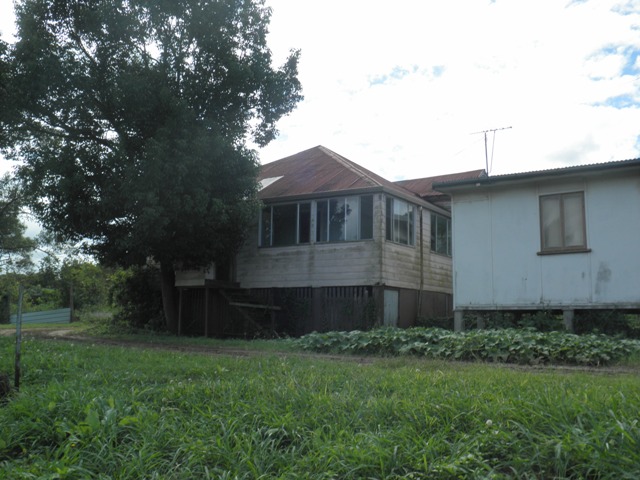

This is an image of the local heritage place known as Klumpp's Farmhouse 1
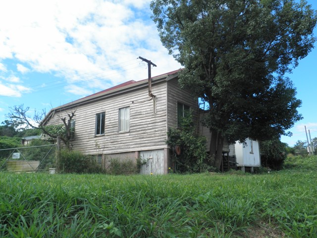
This is an image of the local heritage place known as Klumpp's Farmhouse
Klumpp's Farmhouse
Addresses
Type of place
House
Period
World War I 1914-1918
Style
Queenslander
The Klumpp Road farmhouse is the last remaining farmhouse owned and built by the early pioneering family, the Klumpps. Built in 1914 by Henry Klumpp, the son of original pioneer, Frederick Klumpp, the timber residence was constructed close by the original Klumpp farmhouse. The house is important as it represents the history of early farming in the Upper Mt Gravatt area.
Lot plan
L3_RP138498
Key dates
Local Heritage Place Since —
Date of Citation —
Construction
Roof: Corrugated iron;Walls: Timber
People/associations
Henry Klumpp (Occupant)Criterion for listing
(A) Historical; (B) Rarity; (H) Historical associationInteractive mapping
Lot plan
L3_RP138498
Key dates
Local Heritage Place Since —
Date of Citation —
Construction
Roof: Corrugated iron;Walls: Timber
People/associations
Henry Klumpp (Occupant)Criterion for listing
(A) Historical; (B) Rarity; (H) Historical associationInteractive mapping
History
Prior to European settlement the area now known as Upper Mt Gravatt was home to the Yagarabul people. In the mid nineteenth century Tom Petrie reported that the aboriginal people in the Mt Gravatt area called the Mt Gravatt mountain ‘Kaggur-mabul’, meaning ‘place of the echidna’.
As Queensland was opened for free settlement in the mid-nineteenth century the Mt Gravatt area became somewhat of a thoroughfare for the traffic travelling from Brisbane to the Logan area. The first European to traverse this track was William Slack, his stock and wagons carved what was then called ‘Slacks Track’, through Mt Gravatt to the Burnett Swamp (today’s Stones Corner). This track became increasingly popular and became known as the Logan road.
European settlement began in the district as early as the 1860s with the initial land being surveyed in 1864. As settlement occurred and land was cleared the Mt Gravatt district became a predominately farming community with dairy farms, agriculture, vineyards and associated industries such as slaughter yards and mills. A fraction of the labour used for land clearing in this period was from South Sea Islanders (then known as Kanakas).
Specific to the area now known as Upper Mt Gravatt the predominant pioneering families were the Klumpps and the Angers, each with an initial sixty acre selection. Later these settlers were joined by families such as the Kessels, Hughes’, Newnhams, Dawsons, Clauss’ and Grieves’, also intent on establishing farms in the district. The majority of early settlers to the district were of German origin, often enticed to immigrate to Queensland by the Government’s policy of land grants. Agriculture (including fruit orchards and vineyards), cattle, sheep and poultry farming, and horse breeding were the principle sources of income for the settlers. Secondary industries such as a wool scour and abattoirs were also established in the late nineteenth century. Several Chinese families settled in the district and established market gardens and several Afghan and Indian families also moved into the area. The population of Upper Mt Gravatt was slow to increase in this period due to lack of infrastructure and facilities. This was, however, gradually changing.
As the Logan road proved to be the main thoroughfare and trade link to the Logan district and onwards to the coast it was still a rough bush track. An important advancement occurred in the district in the early 1860s with the Cobb and Co. coach service re-directing their Brisbane to Pimpama service through Mt Gravatt. Several hotels were established along the Logan road, including the Glindemann’s ‘German Bridge’ Hotel and the Mt Gravatt Hotel. These hotels were primarily used as passenger pick up and set down points for the coach company as well as to provide guests with overnight accommodation and meals. A changing station for the coach’s horses was located along the Logan road at Upper Mt Gravatt. The coaches also played an important role in the delivery of mail to the more remote areas along the Logan road, including Upper Mt Gravatt. Having this service available to the early settlers was extremely important as it reduced their isolation, albeit marginally. It also encouraged further settlement, as a postal service was perceived as a benefit. The first official Post Office was established at Mt Gravatt in 1877.
In 1914 Henry Klumpp, the son of Frederick Klumpp, constructed a timber dwelling on the Klumpp holding. At the time the house was built there were already several other houses on the farming property built by various members of the Klumpp family including the original Klumpp residence, higher up the hill from Henry’s. Henry and his brother-in-law Jack Trim, established a nursery on the land known as the “Hillside” nursery. Henry had established a business in South Brisbane called the “Seedman Shop” to sell the products grown on the farm.
The modest timber farm house is situated on a rise above the busy Mains/Klumpp Roads, and as such is a reminder of the significance of farming to the Upper Mt Gravatt district, as well as being a testament to the pioneering zeal of the early farmers.
Description
The Klumpp farmhouse is a modest timber residence situated on a rise above the busy Mains/Klumpp Roads. The house consists of a pyramid bungalow roof, one street-facing window, half front verandah under bungalow roof that has been built in at a later date.
Statement of significance
Relevant assessment criteria
This is a place of local heritage significance and meets one or more of the local heritage criteria under the Heritage planning scheme policy of the Brisbane City Plan 2014. It is significant because:
References
-
Brisbane City Council, Properties on the Web, post-1946 building approval cards
-
Brisbane City Council, 1946 aerial photographs.
-
Brisbane City Council’s Central Library, local history sheets
-
Department of Natural Resources, Queensland Certificates of title and other records.
-
Mt Gravatt District Historical Association, Jump on the Bus – brief history and commentary of Mt Gravatt District Heritage Tour, Brisbane: Mt Gravatt District Historical Association, 1997
-
Mt Gravatt State School, Mt Gravatt State School 1874-1974 Centenary Booklet, Brisbane: Mt Gravatt State School, 1974
-
Robinson, Gwen. Mt Gravatt: Bush to Suburb. Brisbane: self published, 1988
-
Mt Gravatt District Historical Association, Mt Gravatt: Then and Now, an Historical & Pictorial Look at the Mt Gravatt Area from the Late 1800s to the Early 2000s, Volume 2, 2007
Citation prepared by — Brisbane City Council (page revised September 2020)