Addresses
Type of place
Bridge
Period
Interwar 1919-1939
Style
Stripped Classical
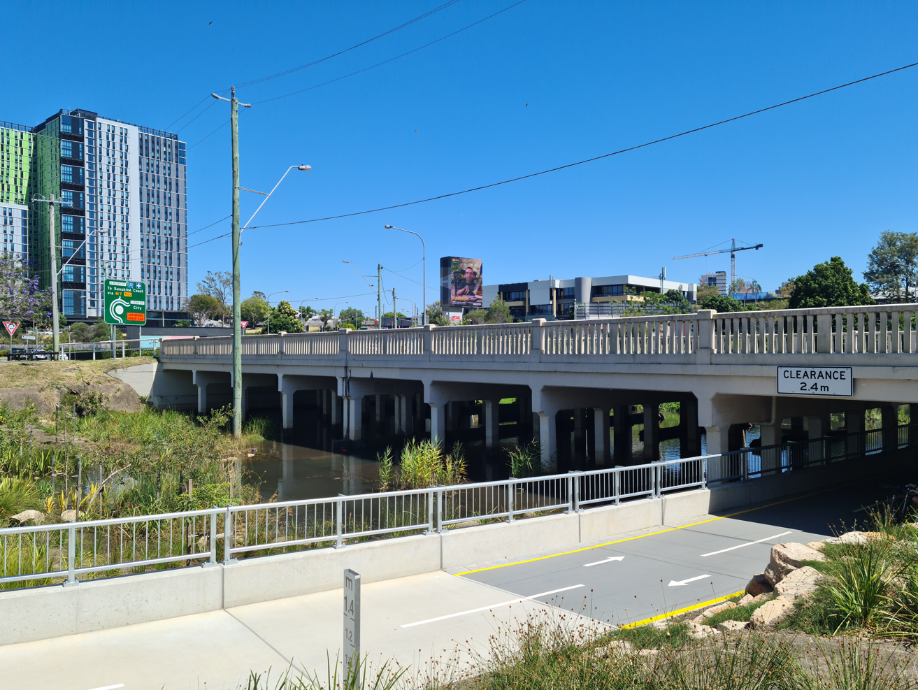

This is an image of the local heritage place known as Burnett Swamp Bridge
Burnett Swamp Bridge
Addresses
Type of place
Bridge
Period
Interwar 1919-1939
Style
Stripped Classical
The bridge was built in 1928 to carry tram and other vehicular traffic across Norman Creek to Stones Corner. It was first called the Buranda Bridge. It is one of Brisbane’s oldest, reinforced concrete, creek crossings. Its configuration without longitudinal girders indicates an early approach to provision for waterway maximisation at a flood-prone site. It was designed by eminent engineer C.B. Mott. He was the first Designing Engineer of the Greater Brisbane City Council, later to become Chief Engineer and Manager of the Council’s Department of Works.
Geolocation
-27.498101 153.042764
Key dates
Local Heritage Place Since —
Date of Citation —
Construction
StructurePeople/associations
Charles Mott (Engineer);E. F. Gilchrist (Association)
Criterion for listing
(A) Historical; (D) Representative; (E) Aesthetic; (F) Technical; (H) Historical associationInteractive mapping
History
A local authority, a board with representatives from Coorparoo Shire and South Brisbane Municipality, managed the building of a timber bridge over Burnett Swamp at Logan Road during the early 1890s, at a cost of £1600. This was possibly the second crossing at this location. It would have been designed for horse-drawn traffic. Later in its life, it was carrying motor vehicles and electric trams, for which it would surely not have been designed. Its three main spans were 36ft. (11m), the abutment spans of 27ft. (8.8m).
In 1918, the South Brisbane City Council let a tender for the widening of the bridge to provide a six-foot footway on either side of the carriageway. The footways were supported by additional (outer) rows of concrete piers on 4’-0” (1.2m) square spread footing bases. The bridge width increased from 34’-3” (10.4m) between kerbs to 50’-0” (15.2m) between the outer handrails. The bridge was 166ft. (50.6M0 long. The contractor John R.W. Hyde signed the drawing on November 4th 1918, the City Engineer James Louttit having signed it on 12th October 1918. Louttit, on amalgamation in 1925, became district engineer, No. 5 District. He is one of Queensland’s eminent engineers.
In 1923, after qualifying as an authorised surveyor, the 27-year old Charles Mott became the Assistant City Engineer of the South Brisbane City Council, Louttit’s assistant. At amalgamation, Mott was to become the Greater Brisbane City Council’s first Designing Engineer. Mott served the Council for 39 years, retiring from the position of Chief Engineer and Manager, Department of Works. Mott is another of the eminent Queensland engineers.
In 1925, shortly after amalgamation, the Burnett Swamp Bridge was one of several timber bridges in Greater Brisbane reported to be in a sorry state of disrepair. At its meeting on 27th October 1925, Alderman A. Laurie gave the Council notice of a motion for the next meeting to request the Works Committee and the Engineer at an early date to consider a new, concrete bridge, of width adequate to provide for the traffic of the day, to replace the existing bridge, described as in a dangerous condition.
At the next meeting, on 3rd November, the matter was duly referred to the Works Committee.
At its meeting on 18th November 1926, the Works Committee (Minute No. 55) south 25% of the cost of rebuilding the bridge from the Tramways Department. The rebuild would widen the bridge from 50 to 66 feet, and increase the waterway below. The old bridge had been built before the tramway and was not altered when the rails were laid upon it.
The Transit Committee met on Thursday 2nd December and considered the recommendation of the Works Committee, rejecting it but offering “to bear the heavy expenditure required for relaying and deviating the tracks and altering the levels of curves” necessitated by the new bridge (Transit Committee report item 346). The decision was not unanimous, Alderman Long and Oxlade dissenting.
By this time, the design was nearing completion, by or under the supervision of C.B. Mott. Mott and City Engineer Gilchrist signed the design drawings on 10th December 1926. The drawings are numbered B-10-53. At its meeting on 13th January 1927, the Works Committee had before it the plans and specifications for the proposed bridge, and a brief description of the main features and an outline of proposed method and traffic arrangements for construction of the bridge. These were brought before the council meeting on 18th January, which accepted the Works Committee’s recommendation to go to tender for construction of the bridge. Tenders were called, for contract No. 9/1297. Taylor Bros. of Thorn Street, Ipswich submitted the lowest of seven tenders, £12,545.2.2. Subsequently, Messrs. Taylor Bros. tender was found to be in order and accepted. The Departmental estimate for the work was £14203.0.3. At the 242nd Council meeting on 23rd July 1928, when the bridge was under construction, it was recommended that the bridge be named ‘Buranda’. The name has since fallen into disuse, and in some quarters has reverted to the name of the old timber bridge that it replaced, the Burnett Swamp Bridge.
Description
Burnett Swamp, now known as Hanlon Park and no longer a swamp, lies at the downstream extremity of Ekibin Creek, one of several creeks with Mount Gravatt at their head. Buranda Bridge may be taken as the point at which the creek changes its name to Norman Creek.
The catchment above the bridge is 4134 acres. The area under the bridge is level and concreted for scour protection, concrete aprons extending the sealed area upstream and downstream of the bridge extremities. The fully lined low v-shaped low flow channel, 4’-6” (1.37m) deep, is constructed under the easternmost of the eight spans, adjacent to the eastern abutment. The absence of longitudinal girders across a relatively shallow waterway is an indication that the waterway maximisation was a prime design consideration.
The bridge has an overall width of 66feet (20.1m) with 54 feet (16.5m) roadway and two 6 feet (1.8m) footways. Kerb height is 8” (200mm). Tram rails, now covered, are at 9’-3-1/2” centres, centrally located in the deck, except for a curve developed over the westernmost span. The total length of the bridge is 140 feet (42.7m). There are eight spans of 17’-3” (5.3m). Provision is made for the expansion at the centre pier.
The bridge is supported on concrete sills, founded on gravel or piles. Abutments are founded on piles. Columns supporting headstocks are 14” (355mm) square. The 18” (457mm) wide headstocks, cast integrally with the 15” (380mm) deck, are of depth 3’-9” (1.143m) inclusive of deck thickness.
Roadway crowning of 1 in 50 is achieved by unreinforced concrete in which the tram rails are laid. Designed footway surfacing was of 1-1/2” (37mm) asphaltic concrete.
The handrail balusters measure 4” X 3” (100mm x 75mm) with 4” (100mm) spaces throughout. Posts are located at headstocks and at mid-spans. Those at the headstocks are ornamentally capped. A plaque was attached to the inner side of the upstream western end post, but is no longer in place.
The bridge is of simple, pleasing appearance. Consequently is has become a major local landmark, the more so since the establishment and later improvements of Hanlon Park, upstream.
Statement of significance
Relevant assessment criteria
This is a place of local heritage significance and meets one or more of the local heritage criteria under the Heritage planning scheme policy of the Brisbane City Plan 2014. It is significant because:
Citation prepared by — Brisbane City Council (page revised November 2022)