Addresses
Type of place
House, Farm, Dairy, Process (other)
Period
Victorian 1860-1890
Style
Free Gothic
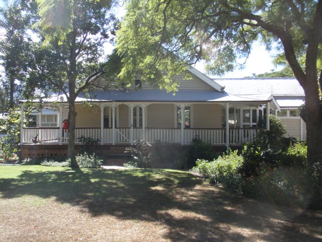

This is an image of the local heritage place known as Residence 'Kenmore Park'
Kenmore Park homestead
Addresses
Type of place
House, Farm, Dairy, Process (other)
Period
Victorian 1860-1890
Style
Free Gothic
Kenmore Park is a remnant of the house and dairy property created by Andrew Todd that gave its name to the suburb of Kenmore. Established in the early 1880s, the development of the property and its various uses reflect the evolution of the locality over approximately 125 years.
Lot plan
L1_SP288790
Key dates
Local Heritage Place Since —
Date of Citation —
Construction
Roof: Corrugated iron;Walls: Timber
People/associations
Andrew Todd (Occupant)Criterion for listing
(A) Historical; (H) Historical associationInteractive mapping
Lot plan
L1_SP288790
Key dates
Local Heritage Place Since —
Date of Citation —
Construction
Roof: Corrugated iron;Walls: Timber
People/associations
Andrew Todd (Occupant)Criterion for listing
(A) Historical; (H) Historical associationInteractive mapping
History
Kenmore Park is a timber and tin residence built for Andrew Todd circa 1882 on 99¾ acres (40.37 hectares) of land in what was then called Indooroopilly, about 6½ miles (10 kilometres) from Brisbane.
The land was originally purchased from the Crown in 1867. It passed through several owners but remained undeveloped, apart from tree clearing, until purchase of Portions 169, 170 and 174-177 by Andrew Todd in 1880. Todd built a colonial transverse gable house comprising four rooms with a kitchen on the rear verandah and a front verandah with stepped concave roof supported by single verandah posts. He fenced paddocks and constructed dairy buildings on the property, and commenced dairy farming and stud breeding. Todd’s brand was registered in 1882 and in 1885 he exhibited his Jersey cattle, including a stud bull, at the Royal National Show and won a number of prizes.
Todd was a benefactor to the Presbyterian Church donating both money and half an acre of land fronting today’s Kenmore Road, on which a church was constructed for £153 in 1885.1 The church was recorded as Kenmore Church, which was the first wider use of the name ‘Kenmore’ in the area. Todd sold Kenmore Park in October 1893 and retired to his native Scotland.
Kenmore Park was purchased by wealthy Queensland identity James Stevenson, pastoralist, land developer and member of the Queensland Legislative Assembly (MLA) 1876-93. Stevenson never resided at Kenmore Park as his home from 1882 until 1910 was Fernberg. Instead, his brother-in-law, Edward Palmer (pastoralist and MLA 1883-96), managed the property and maintained the dairy herd established by Andrew Todd. When Stevenson lost most of his wealth during the 1890s depression he was unable to repay his Kenmore Park mortgage and ownership of the property transferred to the Queensland National Bank in 1897. While the Queensland National Bank owned Kenmore Park it was leased to various tenants as a dairy.
Frederick John Moore, chief buyer for the Redbank Meat Works, leased Kenmore Park between 1907 and 1921, at which time, he and his wife purchased it. From 1911 Kenmore Park was used as a holding area for bullocks and sheep which were slaughtered on site for Moore’s retail butcher shops in Fortitude Valley. Tallow was produced as another end-product. Pigs were also bred and raised for slaughter. Six other slaughter yards were in operation in the Kenmore district (Moggill Shire) at the time, but Kenmore Park was the biggest operation in the period 1911-15. After its closure in 1916 Moore and his family returned to the property where they added verandahs to the house and refurbished it. Dairying continued on the property as well as cultivation. The family left the property in 1923 or 1924 to reside at Indooroopilly.
A number of tenants and share farmers occupied Kenmore Park until 1953 when it was subdivided and auctioned as 67 “magnificent allotments” each with “glorious view” from “40 perches to 9¾ acres”.2 This subdivision reflected the changing nature of the Kenmore area from rural to suburban as more people moved into the area. Being only 6-7 miles from the CBD it was within commuting distance from Brisbane by motor car.
When the land was surveyed for subdivision the house was deliberately placed within the bounds of one of the housing blocks. The 1 acre 17½ perch block on which Kenmore Park house stood was purchased in 1955 by the current owner, David Cornell Stewart. Subdivision of the block occurred soon after purchase, leaving the house block with 2 roods 27½ perches. The house has had multiple internal changes and extensions in the 51 years of the owner’s residence as the family expanded and aged. Today the residence reflects the middle-class affluence of the suburb of Kenmore that has developed post-World War II and to which it gave its name.
Description
The original residence, built around 1882, was a typical colonial transverse gable house with four central rooms under the main gable and a front verandah with a stepped concave roof supported by single verandah posts. A kitchen and store were located at the rear with a south-facing verandah. The house had sash windows and modest ornamentation. In the 1920s two verandahs were added to the house on the southern and northern sides. The central lounge was extended onto the northern verandah and a verandah office created on the northern corner of the house. In the early 1960s the main entrance was moved from the western verandah to the southern verandah facing Acworth Street. Reorganisation of the usage of the rooms occurred then, and subsequently additions were made to the north-west and north-east of the house. The floor plan and fabric of the original 1880s house are incorporated within the expanded house.
Statement of significance
Relevant assessment criteria
This is a place of local heritage significance and meets one or more of the local heritage criteria under the Heritage planning scheme policy of the Brisbane City Plan 2014. It is significant because:
Supporting images
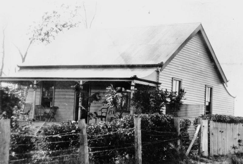
Elevation from West, circa 1895. (John Oxley Library, Image No. 44638b)
References
-
BCC City Plan Heritage Register citation for Kenmore Uniting Church
-
Notice of Public Auction of Kenmore Park Estate, The Courier Mail, 5 December 1953
-
Brisbane City Council, Property Site History, Building Cards
-
Brisbane City Council WebBASX maps – cadastre, 1946 aerial, 2001 aerial, 2005 aerial
-
Brisbane Images, photograph, corner Kenmore and Gilruth Roads, Kenmore 1960, www.brisbane.qld.gov.au/uhtbin/hyperion-image/BCC-B54-13460, accessed 15 August 2006
-
Brisbane Images, photograph, corner Moggill and Brookfield Roads, Kenmore, 1960, www.brisbane.qld.gov.au/uhtbin/hyperion-image/BCC-CD4-1, accessed 15 August 2006
-
Brisbites Suburban Sites, Kenmore, www.brisbites.com/suburbView.asp, accessed 15 August 2006
-
Department of Natural Resources and Mines, Queensland Certificates of Title
-
Department of Natural Resources and Mines, Placenames, at www.nrm.qld.gov.au/property/placenames/print.php?id-41505, accessed 14 August 2006
-
History of Government House at www.govhouse.qld.gov.au/government_house/history.asp accessed 15 August 2006
-
Judy Gale Rechner, Brisbane House Styles 1880 to 1940: a guide to the affordable house, Brisbane: Brisbane History Group Studies No. 2, 1998
-
Stewart, Jean. Kenmore Park: The Land, the House and the People. 2nd ed., J. and D. Stewart, Brisbane, 2003
-
Wager, Libby. Mud-maps of Moggill, Pullenvale Field Study Centre, 1988
Citation prepared by — Brisbane City Council (page revised June 2024)