Addresses
Type of place
Farm house, Farm
Period
Federation 1890-1914
Style
Queenslander
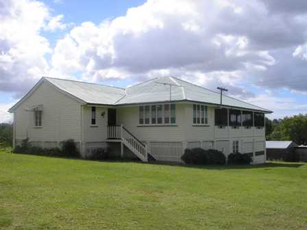

This is an image of the local heritage place known as Drew Farmhouse
Drew Farmhouse
Addresses
Type of place
Farm house, Farm
Period
Federation 1890-1914
Style
Queenslander
This farmhouse was built around 1907 for Frederick and Florence Drew when most of the original large Aspley District land holdings were being subdivided into small farms to service the J.C. Huttons factory. The Drew’s farm was unusual in that it retained the original 62-acre land grant dating from 1867 and it remained a large farm until 1958 when part of it was subdivided for urban development. Substantially intact, it remains as a reminder of Aspley’s rural heritage.
Lot plan
L13_RP809981
Key dates
Local Heritage Place Since —
Date of Citation —
Construction
Roof: Corrugated iron;Walls: Timber
Criterion for listing
(A) Historical; (B) RarityInteractive mapping
Lot plan
L13_RP809981
Key dates
Local Heritage Place Since —
Date of Citation —
Construction
Roof: Corrugated iron;Walls: Timber
Criterion for listing
(A) Historical; (B) RarityInteractive mapping
History
This property was part of 62 acres of crown land purchased for ₤62 by Aaron Adsett on 19 August 1867. Adsett, of Brisbane, bought Portion 24 in the Parish of Kedron, situated on the right bank of Cabbage Tree Creek or Tighgum Creek as it was also known. Around the same time, Adsett bought the adjacent Portion 23 comprising 74 acres. The Old Northern Road that led from Brisbane to Caboolture was the northern boundary of Adsett’s land purchase.
John Blanc, of Brisbane, obtained the land on 18 February 1881. Blanc was a butcher, living in Ann Street in Fortitude Valley. He also may have been a land speculator and accomplished entrepreneur for he obtained no less than 7 mortgages on this land during the period 1881 to 1890. Blanc mortgaged the land for ₤150, on 3 March 1881, through the Brisbane Permanent Benefit Building and Investment Society. On 23 March 1881, he remortgaged the property for ₤800 through John Elairthy. Another mortgage, for ₤3,000, was taken out on 20 December 1881 through the Queensland Investment and Land Mortgage Company Limited. Then on 19 December 1894, Blanc arranged a further mortgage, this time for ₤5,000, through the South Australian Land Mortgage and Agency Company Limited. Three days later, on 22 December, Blanc again mortgaged the land and obtained ₤400 from John Thomas Brigg. The property was mortgaged again on 27 August 1887, when Blanc received ₤1,500 from Thomas Rome. Squeezing the last loan that he could get for this land, Blanc took out a mortgage for ₤5,500, through the Australian and New Zealand Mortgage Company Limited on 3 March 1890.
Commencing with properties along Graham Road, the original large land grants in the Aspley district were broken-up into small farms from the 1890s. The catalyst was the opening of the J.C. Hutton smallgoods factory at Zillmere in 1888. The new small farms being created in Aspley were meant to become viable by growing fruit or pigs that could be sold to Huttons. This second wave of development in the district had largely run its course by the 1920s when post-war British migrants moved onto some of these farms. That Portion 24 was not subdivided for such purposes made it unique and, in fact, Portion 24 was to retain its 1867 boundaries until 1958, when a third wave of development completely altered rural Aspley.
George Early became the next owner of Portion 24 on 19 March 1907. Early purchased the land for his daughter Florence Annie Drew, the wife of Frederick William Drew. Frederick Drew’s father was Samuel Drew who had been involved with the building of the Sandgate Post Office. Samuel Drew erected the farmhouse at 700 Trouts Road, with the building completed by July 1907. After George Early’s death on 18 June 1909, his estate passed to his widow Anne Bertha Early. Anne Early transferred the title deeds to her daughter Florence on 22 February 1910. By this time, Trouts Road had become the eastern boundary of the property. According to the Queensland Post Office Directories, Frederick W. Drew was a farmer, whose name is listed for the first time as a resident of Aspley, in the 1919-1920 edition.
On 14 March 1923, dairyman William Joseph Burns, of Aspley, took ownership of Portion 24. In an effort to expedite the property transfer, Florence and Frederick Drew provided a mortgage ₤3,000 to Burns, on the day of purchase. The Queensland Post Office Directories indicate that Burns never lived on the property during the short time that he owned it. Burns was unable to repay the mortgage and so, on 28 April 1925, Florence and Frederick Drew regained Portion 24. By 1946, when aerial photographs of the property were taken, the farm’s layout consisted of the farmhouse, a main farm shed that was about four times the size of the Drew residence, and a cluster of smaller sheds at the back of their house. The large shed (since demolished) housed dairy cattle, farm machinery and the bore that was the source of water for the farm. When Frederick Drew died on 8 July 1946, his estate passed to Florence. But Florence only outlived her husband by a few months and when she died on 4 March 1947, her estate passed to William Roy Drew.
Russell Fairley Thomas and George Oswald Thomas obtained Portion 24 on 12 July 1949. They mortgaged the farm on 18 December 1957 through the Commercial Bank of Australia Limited (CBA). By this time, the Aspley district was beginning to change, from a rural community dotted with small farms, into a trendy Brisbane suburb full of new housing estates. Increasing popular with homebuyers was the acreage block that combined a suburban lifestyle placed in a rural setting. Therefore the mortgage taken out by George Thomas and his son Russell may have been used to pay for charges and infrastructure required for the conversion of their farm into an acreage estate. For on 1 July 1958, Russell and George Thomas subdivided Portion 24 into 14 acreage blocks. They disposed of the first block, subdivision 10, to Archibald and Ann Bidgood on 24 February 1959.
On 29 July 1958, Maurice Brooks and his wife Noela Leslie Brooks purchased subdivision 13. This block comprised 2 acres, 2 roods and 4.8 perches, including the farmhouse and land that is now 700 Trouts Road. Around the same time, the Brooks also acquired the 9 acres and 20.4 perches of land in subdivision 14. Final settlement for the sale of these properties occurred on 13 April 1959 thus making the Brooks one of the largest landowners in the area that had once been defined as Portion 24. Maurice Brooks was a market gardener, whose main source of income came from his proprietorship of the Brook’s Joinery Works situated at 276 Gympie Road, Kedron. Maurice Brooks died on 2 January 1963 and his estate passed to Noela.
The farmhouse and land on subdivision 13 transferred to the ownership of Maurine Harriet Donovan and her husband Kevin Austin Donovan on 13 September 1965. On the 18 November 1965, the Donovans obtained a mortgage on their property through the Bank of New South Wales (now Westpac). On 25 February 1974, Brisbane City Council approval was gained for the erection of the large store shed, costing $5,000 that sits on the southern side of the farmhouse.
As the demand for residential development in Aspley and in the new suburbs of Carseldine and Bridgeman Downs increased during the late 1980s, there was a corresponding demand for matching government infrastructure to service these suburbs. On 23 October 1991, the Donovans had to subdivide their property, as a prelude to a resumption of land by the Department of Transport. They lost a part of their land to the Main Roads Department in 1991. This strip, designated subdivision 14, was resumed on 23 October 1991 and it reduced the Donovan’s land to 4,923 square metres. A new title deed, issued to the Donovans on 28 January 1992, marked the existing boundaries of the property at 700 Trouts Road.
Description
This residence and later farm shed are sited along Trouts Road in Aspley, on a reasonably large block of land that had once been used for farm purposes. Both structures are of lightweight construction with a corrugated iron roof.
The house, clad with timber boards, appears to have been modified over time and now presents an asymmetric roof with a transverse gable projecting from the main roof in the direction of the farm shed. The current entry door to the house is to the side of the transverse gable via a flight of narrow steps. This is the original back entrance to house, whose front faced Albany Creek Road. The residence, presently on concrete stumps, sits on a gentle slope reaching the two-storey height down the lower end of the slope. At this end, two bays of the subfloor are used as garage spaces, while a boarded wall with a casement window encloses another bay. One bay is left vacant and the rest of the bays are infilled with a mesh screen.
On the upper level a partially enclosed verandah spans the front of the house and seems to have been originally encircled it. The roof extends over the verandah supported by slender timber posts with simple brackets. The enclosed section of the verandah, which is the closest to the adjacent shed, presents a large casement window with coloured glass panes. Similar coloured glass panes are visible at the front single window adjacent to the entry door. The house appears to be in fairly original condition.
According to the 1946 aerial photograph of the site, a considerably larger old farm shed was located in place of the existing one. The old farm shed had a dirt driveway connecting to the residence and to Trouts Road.
Statement of significance
Relevant assessment criteria
This is a place of local heritage significance and meets one or more of the local heritage criteria under the Heritage planning scheme policy of the Brisbane City Plan 2014. It is significant because:
References
-
Brisbane City Council, Properties on the Web, website
-
Brisbane City Council, 1946 aerial photographs.
-
Brisbane City Council’s Central Library, Local History files – Zillmere – Geebung – Aspley – Bald Hills.
-
Brisbane City Council’s Heritage Unit, A History of Extractive Mining Industries of the Brisbane Area, (Brisbane: Heritage Unit, 1990s).
-
Department of Natural Resources, Queensland Certificates of title and other records.
-
Donovan, Maurine, telephone conversation with Dr Jack Ford of the BCC Heritage Unit, 5 November 2001
-
John Oxley Library, Parish of Nundah, County of Stanley, L.A.D. of Brisbane map, (1899 land grant map).
-
Queensland Post Office Directories, 1868 – 1949 editions
-
Teague, D.R., The History of Aspley, (Brisbane: Colonial Press, 1972).
Citation prepared by — Brisbane City Council (page revised September 2020)