Addresses
Type of place
Cemetery
Period
Victorian 1860-1890

This is an image of the local heritage place known as Sherwood Anglican Cemetery
Sherwood Anglican Cemetery
Addresses
Type of place
Cemetery
Period
Victorian 1860-1890
Also known as
St. Matthew's Cemetery
Lot plan
L1_RP29612
Key dates
Local Heritage Place Since —
Date of Citation —
Criterion for listing
(A) Historical; (C) Scientific; (D) Representative; (G) SocialInteractive mapping
Also known as
St. Matthew's Cemetery
Lot plan
L1_RP29612
Key dates
Local Heritage Place Since —
Date of Citation —
Criterion for listing
(A) Historical; (C) Scientific; (D) Representative; (G) SocialInteractive mapping
History
The district now known as Sherwood was occupied by graziers from the 1840s. By 1860 the land was subdivided into farming lots and closer occupation followed. Early farmers grew crops of grain and vegetables and later added commercial crops of cotton and sugar. From the 1860s a number of churches of the various denominations began to be established in the area. Presbyterian worship began in 1863 with a weatherboard church being erected in 1867. A non-denominational church was also built in the Oxley area in 1865. This slab building was constructed "for the religious and secular instruction" of the local inhabitants and was used on Sabbath mornings for Church of England services and open for the use of other Protestant religions during the remainder of the day.
The first Anglican church in Sherwood was built on the site of the Church of England cemetery fronting Sherwood Road in 1868. The church was constructed of brick and stone and was consecrated by the Right Reverend Bishop Tufnell on 13 January 1874. In 1875, the construction of the railway and the Indooroopilly railway bridge, provided the impetus for early residential development and increases in the local population. The congregation gained its first resident minister in 1876, when the Reverend J.S. Hassell took up the post, which he held until his retirement in 1899.
Due to deterioration the original church was replaced by a timber structure, which was opened by the Anglican Bishop of Brisbane and the State Governor, in 1893. On 27 September, 1921 a further disaster beset the parish; the wooden church, church records and cemetery records were destroyed by fire.
On 8 November a parish meeting elected to rebuild on a site opposite the state school, nearer the centre of population. The Parish hall which was still intact and located on the Anglican cemetery site was to be re-located to the new site. The new brick church was constructed in 1923.
Description
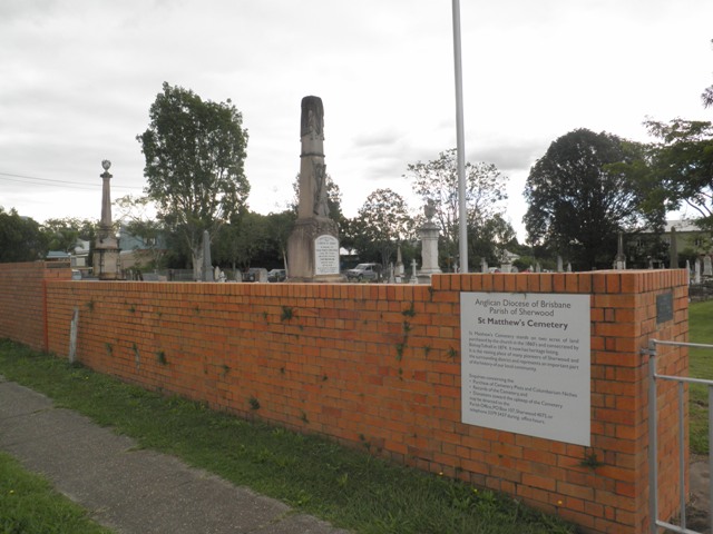
The Sherwood Anglican Cemetery is located at the corner of Sherwood Road and Egmont Street. The subject site contains a large variety of graves and monuments and a number of mature trees.
The cemetery is located in the suburb of Sherwood, approximately 8 kilometres south west from Brisbane city centre. The area around the subject site has a mixed character with medium to low density residential to the west and a rail line and an industrial area to the east. St Matthews Anglican Church is located near the cemetery, at the corner of Oxley Road and Sherwood Road.
The subject site is rectangular in shape with its longest side fronting Sherwood Road. The Sherwood Road boundary features a face brick wall extending approximately 35 metres and a wire fence with steel posts encloses the remainder of the site. A concrete path extends along Sherwood Road and a concrete crossover leads to a wrought iron gate in the brick wall, providing pedestrian and vehicular access to the cemetery. The gate features three crucifixes. A plaque is fixed to the brick wall west of the entry gate.
Graves and monuments are arranged around a main north-south axis just west of the centre of the site and a secondary axis extending east. Graves are aligned in rows running north to south with uneven spaces between. There is a large variety in the structures on the site with many different scales, materials, styles and ages represented. It is noted that smaller, more modern headstones are grouped at the eastern side of the site in a lawn cemetery setting. A face brick columbarium wall is located east of the main axis near the entry gate. Opposite this is a flag pole.
Two medium sized trees are located either side of the main axis, framing the entrance to the cemetery. The subject site features a tall bunya pine located at the centre. Other mature trees line the north, west and east boundaries of the subject site. A small flower bed is situated at the south west corner of the cemetery.
Aerial imagery from 1946 shows that the cemetery was square in layout with the main axis being at the centre of the site. The face brick wall and wire fence is a later addition. The subject site is in good condition.
Statement of significance
Relevant assessment criteria
This is a place of local heritage significance and meets one or more of the local heritage criteria under the Heritage planning scheme policy of the Brisbane City Plan 2014. It is significant because:
References
-
Queensland Heritage Register Entry: 600292 Berry & McFarlane Monument. Brisbane City Council. Heritage citation for St Matthews Anglican Church
Citation prepared by — Brisbane City Council (page revised September 2020)