Addresses
Type of place
House
Period
Interwar 1919-1939
Style
Queenslander
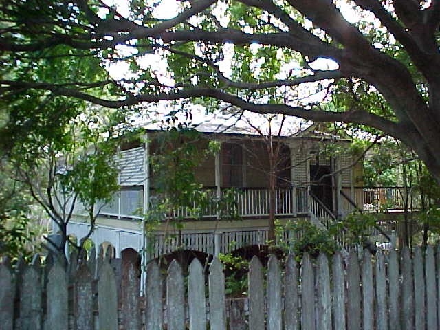

Clauss' Farmhouse from Troubridge Street
Clauss' Farmhouse
Addresses
Type of place
House
Period
Interwar 1919-1939
Style
Queenslander
The Clauss family farmhouse was built circa 1920, replacing the original family farmhouse that was located near the present intersection of Logan Road and Springwood Street. The family continued to own both of the neighbouring farms and used part of the land as a plant nursery to supplement their income. In 1951, the Chester family purchased all of the Clauss family’s land holdings and subdivided the land into new housing estates and a shopping precinct, stimulating residential growth and development in the area. That same year, Adam Clauss regained title to the family home and it was retained in the family until 1982. It has since had a number of different owners. The house was built in the Queensland vernacular style of the Federation period although it appears to have been constructed as late as 1920.
Lot plan
L2_SP177344
Key dates
Local Heritage Place Since —
Date of Citation —
Construction
Roof: Corrugated iron;Walls: Timber
Criterion for listing
(A) Historical; (B) RarityInteractive mapping
Lot plan
L2_SP177344
Key dates
Local Heritage Place Since —
Date of Citation —
Construction
Roof: Corrugated iron;Walls: Timber
Criterion for listing
(A) Historical; (B) RarityInteractive mapping
History
Prior to the naming of Mt Gravatt by government surveyor Robert Dixon in 1839, the local Aborigines called the mountain Kaggur-mabul. Dixon named the mountain after Lieutenant George Gravatt, who was overseeing the closure of the Moreton Bay Penal Colony. The convict settlement closed in 1842 and the area was opened up for free settlement. The land containing this farmhouse was first offered for sale in 1865. On 17 February of that year, Edmund Walter Brittain bought 22 acres and 27 perches of undeveloped land described as Portion 200 in the Parish of Bulimba. It cost Brittain ₤22.3s.5d. to purchase the uncleared farmland. On 25 September 1866, John Carr bought the land from Brittain. Carr added Portion 200 to Portion 199 that he had bought on 15 February 1865 for ₤23.1s. This gave Carr a farm totalling 55 acres and 35 perches.
Carr held the property for the next eight years, before selling Portion 199 to James Cooley on 16 February 1874. Two days later Cooley also obtained Portion 200 from Carr. Cooley obtained a mortgage of ₤100 on Portion 199 on 16 February 1874. The lender was John Neil Waugh, who lent a further ₤100 to Cooley on 12 March 1877. This second mortgage was taken out on Portion 200.
An adjoining block of crown land, Portion 250A, was finally put up for sale in 1876. The purchaser was Robert Farrant, who paid ₤36 for 40 acres of land. Farrant transferred ownership of Portion 250A to John Potts on 27 February 1877.
On 17 October 1879, Cooley disposed of Portions 199 and 200 and his mortgages to John Hasell. Hassell may have been acting as simply as an agent for on the same day, Hassell transferred Portions 199 and 200 onto Anastasia Clauss, the wife of a German migrant, Adam Clauss. On 14 January of the following year, Clauss obtained Portion 250A from John Potts.
Thus the 95 acres and 35 perches of land covering Portions 199, 200 and 250A became the Clauss Farm. The family became major landholders within the Mt Gravatt district, with their farm gradually being subdivided into portions for the use of particular family members. Thus on 12 July 1897, Adam Clauss subdivided Portion 250A into two 20-acre lots. One lot was added to Portion 200 that was then passed onto Clauss’s son, Conrad Adam Clauss, on 16 July 1897. Portion 199 with the other half of Portion 250A was passed to his other son, Johann George Clauss, on 24 July 1897.
According to the Mt Gravatt District Historical Association, the residence at 15 Troubridge Street was built for coachbuilder Henry Clauss around 1920. Another source claims that it was built for nurseryman Adam Clauss in 1926. What it certain is the house is of a Federation period style and it was built for a member of the Clauss family. It replaced the original Clauss Farmhouse built by Adam Clauss near the present intersection of Logan road with Springwood Street. The new house appears to have been built near the dividing line between the two farms that had been given to Adam’s sons. The house faced Logan Road which provided access to both the small nearby Mt Gravatt Township and to main retail precinct in the City. The Clauss Family utilised their land as a plant nursery to supplement their income from farming.
When Conrad Clauss died on 18 March 1929, his widow, Mary Clarisa Clauss, inherited his 42 acres and 27 perches of farmland. Johan Clauss died on 15 September 1946, with his farm passing to his son Henry Adam Clauss. On 6 April 1951, after the death of Mary Clauss, family trustees handled her farm for a few months. At that time, Brisbane was experiencing a post-World War Two housing boom. With the opening of the extension of the Logan Road tramline to Mt Gravatt on 10 March 1951, the area began to change from a farming district to new suburban estates. The state government created new housing commission and war service housing estates off Creek Road and Cavendish Road. As a result, land and housing developer, the Chester Family moved to buy both of the Clauss farms.
George Chester, Leslie George Chester and Ronald Thomas Chester, along with their partner, David Lloyd Morgan, purchased the entire Clauss farm holdings 6 July 1951. These men were to be the major influence on the shape of the new Mt Gravatt. Not only did they subdivide the farmland into new housing estates but also they built some new shops near the Logan Road and Creek Road intersection to service these estates. Chester’s shops would become the nucleus of a new suburban shopping precinct, which by the early 1960s, had become known as “the Terminus” because it marked the end of the tramline. The housing estate that incorporated Adam Clauss’s farmhouse was given the unremarkable title of “Number 3 Housing Estate”.
Henry Adam Clauss was able to obtain the family home from the developers. The house was incorporated into three suburban house blocks listed as Subdivisions 91, 92 and 93 of Portions 199 and 200. Because of the way that the Chesters and Morgan had surveyed the Clauss Farms and then drew up new roads and house blocks, the Clauss Farmhouse no longer had direct access to Logan Road. Instead, the back of the house effectively became the front of the house because it faced the newly created Troubridge Street. Adam Clauss regained title to the farmhouse and just 1 rood and 35.6 perches of the original farmland on 5 November 1951. Adam kept the house until his death on 9 March 1977. The family residence then passed into the hands of Leonard Claude Clauss, who, two years earlier (10 July 1975) had been given Subdivision 91 by Adam Clauss.
On 22 June 1982, the house and land at 15 Troubridge Street finally passed from the hands of the Clauss Family. The new owners were Vaughan Brandon Clipstone and his wife Delynne Joan Clipstone. The Clipstones paid for their home through a loan from the Bank of New South Wales (now Westpac). They mortgaged the property a second time on 15 April 1983. The property appears to have been used for investment purposes for the Clipstones only held the title deeds for three years before disposing of the site. Thus Stewart Taylor Paxton Ginn and Lynnette Robyn Edna Ginn bought the Clauss Farmhouse on 8 July 1985. Westpac also financed their home loan. Before the end of the year, the Ginns had divested themselves of their new purchase when the property passed to Robyn Ann Mactaggart and Peter Nicholas Mactaggart on 20 November 1985. They took out two mortgages on the property, one in 1992 and the other in the following year. The current owners of the Clauss Farmhouse, Wayne Thomas Smith and Vanessa Janine Smith took control of the property on 19 September 1994.
In July 2006 Council approved an application to shift the former farmhouse slightly to the south-east on the block and subdivide the existing block into two lots. A new house has been built at no. 13 Troubridge Street.
Statement of significance
Relevant assessment criteria
This is a place of local heritage significance and meets one or more of the local heritage criteria under the Heritage planning scheme policy of the Brisbane City Plan 2014. It is significant because:
References
-
Brisbane City Council, Properties on the Web, website, post-1946 building cards
-
Brisbane City Council, 1946 aerial photographs.
-
Department of Natural Resources, Queensland Certificates of title and other records.
-
John Oxley Library, Brisbane Suburbs – Estate Maps
-
Queensland Post Office Directories, 1868-1949
-
Mt. Gravatt District Historical Association, newspaper clippings on 15 Troubridge Street
-
Mt. Gravatt District Historical Association, Jump on the Bus, (Brisbane: Mt. Gravatt District Historical Association, 1999)
-
Robinson, Gwen, Mt Gravatt Bush to Suburb, (Brisbane: Gwen Robinson, 1988)
Citation prepared by — Brisbane City Council (page revised June 2022)