Addresses
Type of place
Church, Cemetery
Period
Victorian 1860-1890
Style
Queenslander

Indooropilly Primitive Methodist Church located on 9 Chapel Hill Road in Chapel Hill
Indooroopilly Primitive Methodist Church (former) & historical cemetery
Addresses
Type of place
Church, Cemetery
Period
Victorian 1860-1890
Style
Queenslander
The former Primitive Methodist Church was built on the corner of Moggill and Chapel Hill Roads in 1875. It is the chapel on the hill from which the suburb gets its name. It was built at a time when the Moggill and Indooroopilly area was developing as a farming community and demonstrates the importance of religious worship to the early settlers. It was the first Methodist church in Indooroopilly, has an old community cemetery nearby, and is a fine example of a nineteenth century timber chapel. The chapel demonstrates the commitment of the local Methodist community to establishing and developing their place of worship in the local area. The church building has played a continuous role in the Indooroopilly community since its construction. Chapel Hill developed as a residential suburb from the 1950s and a new church was built near it in 1955. It became the Chapel Hill Uniting Church in 1979.
Also known as
Indooroopilly cemetery
Lot plan
L4_RP119347
Key dates
Local Heritage Place Since —
Date of Citation —
Construction
Walls: TimberCriterion for listing
(A) Historical; (E) Aesthetic; (F) TechnicalInteractive mapping
Also known as
Indooroopilly cemetery
Lot plan
L4_RP119347
Key dates
Local Heritage Place Since —
Date of Citation —
Construction
Walls: TimberCriterion for listing
(A) Historical; (E) Aesthetic; (F) TechnicalInteractive mapping
History
European farming began in the Moggill, Fig Tree Pocket and Long Pocket districts in the 1860s. Wealthy families, drawn by the elevated land and proximity to the river, established gracious villas on large allotments of land. Timber cutting and farming took place around the Chapel Hill creeks, and a small agricultural population developed in what was then considered part of Indooroopilly. The Indooroopilly district extended west from the present-day suburb to Moggill and Seventeen Mile Rocks, with a number of small rural communities dotted around the district.
On 13 August 1873 five acres of land, proclaimed as lot 86, was sold to Joseph Buckle, John Lancaster, James Graham, William Growlet, Thomas Harding and Charles Green as trustees for £3 and 15 shillings. The group were representatives of the Primitive Methodist Indooroopilly congregation, under the charge of Rev Buckle.
The Primitives were the second strongest branch of the Methodist Church in Queensland, only exceeded in congregation numbers by the Wesleyans. Primitive Methodist Services conducted by lay preachers commenced in Brisbane in 1859, and the first minister arrived the following year. A small church was built in Windmell (now McLachlan) Street, Fortitude Valley in 1861. A second church was erected in Adelaide Street shortly afterwards, followed by another in Fortitude Valley.
Reverend Joseph Buckle was appointed to Brisbane in 1863, the second Primitive Methodist minister who served in Brisbane. He arrived from Ballarat in November of that year to open the Oxley Creek Primitive Methodist Church. Over the course of his ministry, the mission-focused Buckle established church buildings in areas where small Primitive Methodist congregations had worshipped, including Bulimba (1866) and South Brisbane (1868). He reported of his service in 1871:
When he first arrived in the colony the members of the Church numbered fifty-seven, but now the number was 228, and the station [i.e. Brisbane] was upwards of 200 miles in length, and had about twenty churches planted in various parts. The income of the station had also increased by about 160 per cent since the time referred to, and their Sabbath schools had grown from two, with a little over fifty scholars, to eleven, with 520.
By 1874 this had become 280 members, with fifteen chapels and calls for an additional ten ministers to work in Queensland. Buckle himself served at circuits or stations throughout Queensland, and was secretary of the Primitive Methodist’s corporation and building committee. From 1885 he lived in ‘Callender House’ on Wickham Terrace, which is listed on the State heritage register [600169]. He died in 1913 in his 59th years of ministry.
An Indooroopilly Primitive Methodist parish commenced worship in ‘cottage services’ at Negus Hill, James Graham’s property, in around the late 1860s. The Indooroopilly district was a focus for a number of religious and community groups at the time. The population of the pastoral settlements in the area was increasing, but the district was too remote for residents to travel to services in Brisbane town, and concerns were expressed that Indooroopilly inhabitants, particularly children, were missing religious services. A Catholic Church, Bible Christian Church and Good Templars lodge were all opened in the early 1870s, providing places of meeting and worship for these rural communities.
The absence of a minister was not a problem for the Primitive Methodists, as the sect allowed lay preaching, and Rev Buckle travelled to the district to conduct weddings in the early 1870s. However, with the growth of both population in the Indooroopilly district and membership in the Primitive Methodist church, the lack of a church building was quickly felt. In August 1873, a correspondent reported to the Brisbane Courier:
The Primitive Methodists are about to build themselves a place of worship, having for a long time held their services in a private house. They have chosen a very eligible site near the junction of Indooroopilly and Moggill Roads…
The site on which the chapel would be located was elevated but vacant. On the hilltop was the conjunction of roads to Brisbane, Moggill, Seventeen Mile Rocks and Mount Coot-tha, while Cubberla Creek flowed through the lower sections of the site. Although the area was sparsely populated, it was a convenient congregation point for a number of settlements, as Moggill Road provided the only land access to Brisbane for the farming communities at Moggill, Kenmore and Fig Tree Pocket. It was also easily reached from Indooroopilly.
A temporary building was opened in November 1873, with a ground-breaking foundation ceremony. Rev Buckle, church members and local pioneers attended. Non-Methodist resident Mr McConnel spoke at the ceremony, reflecting contemporary views of the importance of the church:
[H]aving become a resident in the neighbourhood, I have a special interest with its well-being and prosperity; it is certain that this cannot be attained without seeking the blessing of God and the honour of His cause.
Permission was granted for construction of the building at the Primitive Methodist Brisbane District Conference in January 1874. The contract for construction was taken ‘at a low figure’ by David Hill, a lay preacher in the Primitive Methodist church and contractor who also worked on the first Albert Bridge. Roof shingles were provided by Mr Growlet (or Gowlett) and added, free of charge, by congregation members the Misters Frost. Initially it was uncertain whether the building would be used for services or a Sabbath school, though it appears to have been intended for both.
The church’s important role in the wider community was evident from its opening in March 1875. The dedicatory service for the new church was advertised in local newspapers in the week leading up to the event. The church was called the Indooroopilly and Moggill Primitive Methodist Church, indicating the broad community it was intended to serve. McConnel was again asked to speak at the inauguration, which included a luncheon, public meeting and a social gathering for the neighbourhood. McConnel praised the building, describing it as a ‘neat,
elegant and substantial structure’, while Rev Buckle emphasised its low cost construction, suggesting ‘that it would be one of the best and cheapest of country churches… in Queensland’. It was hoped to cost the church no more than £120, ‘which, considering the kind of material used, the quality of the workmanship, and the size of the building, was indeed a marvel of cheapness’.
Situated as it was on a hilltop and clearly visible in the surrounding area, the church quickly became a landmark in the Indooroopilly district. By the 1880s it was known as ‘Chapel Hill’, later giving rise to the suburb name. Fencing and a water trough were added by the Indooroopilly District Board in the 1880s. By 1878 the site also hosted a burial ground. Tenders were advertised for the erection of fencing at the Primitive Methodist Burial Ground, Indooroopilly, in February of that year. Similar cemeteries were opened by communities in isolated outer western suburbs. Some of these are still extant and are heritage listed, including Brookfield, Moggill, Sherwood Anglican and Pullenvale. Of these only Sherwood was established in conjunction with the church, and the cemetery and church no longer occupy the same site, making Chapel Hill rare.
Although the land was owned by the Primitive Methodist Church trustees, the cemetery was used by the broader community, which included German and British settlers, and denominations other than Primitive Methodist. Burials took place until 1997, and local dignitaries, including William Ross Munro of ‘Ross Roy’, were buried there.
In 1893, a conference of all the various Methodist Church branches saw an agreement for amalgamation into a single Methodist Church. The Methodist Union was approved at a meeting of the Primitive Methodist Church in March, 1895. The Chapel Hill property passed to new trustees in 1906 under the Methodist Church Property Trust Act 1893.
While Indooroopilly opened up for development following the construction of the Albert Bridge and the construction of the railway, the land around Chapel Hill remained agricultural until the mid-twentieth century. A suggestion was made in the 1910s to shift the wooden church to a site in Station Road, Indooroopilly, where population growth was focused. A brick church was constructed there instead, and the Chapel Hill church remained on Chapel Hill. The congregation held working bees to replace the roof shingles with iron and line and ceil the church. A fund was established to undertake further improvements the time of the church’s diamond jubilee in 1932, including painting and constructing a dividing fence between the church and cemetery.
Residential development took place in Chapel Hill from the 1950s. A worship centre was opened in 1955, replacing services held in the chapel. The original building was moved on site. A church hall was added in 1961, with additions in 1968 and 1973. None of these buildings are included in the heritage listing. The land was vested in the Corporation of the Methodist Church of Australia in 1968 and subdivided, with land sales in 1970. In 1979, following the 1977 union of the Presbyterian, Methodist and Congregational Churches, the church and just over four acres of land were transferred to the Uniting Church Property Trust. Further extensions and alterations to the 1955 church building were undertaken from 1988. The church continues to function as the Chapel Hill Uniting Church.
Description
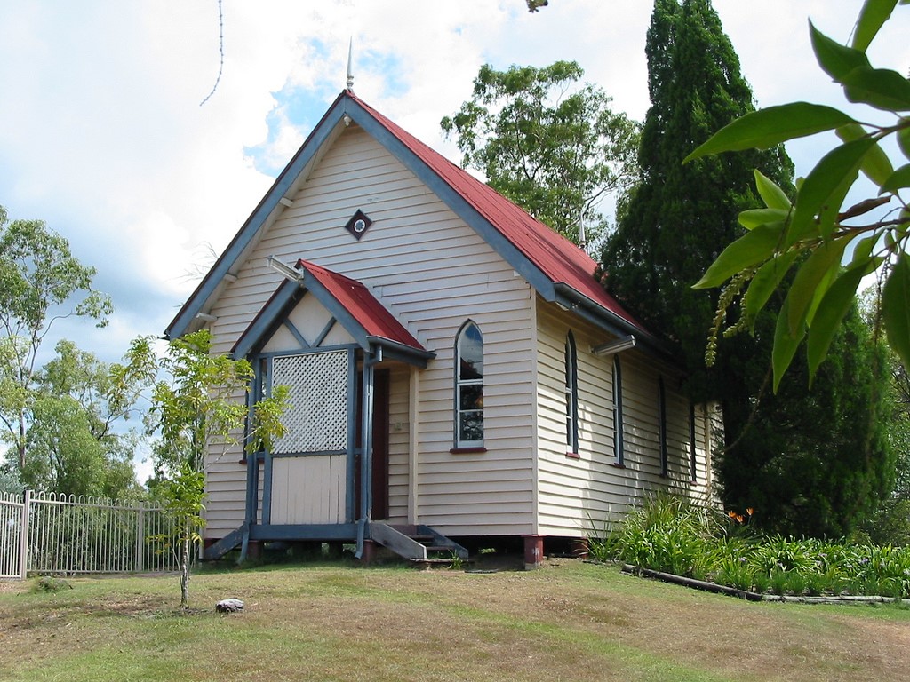
The Indooroopilly Primitive Methodist Church (former) and historical cemetery stands on the crest of a hill on the prominent corner of Moggill and Chapel Hill roads. The church is a modest, timber-framed and -clad structure with a simple rectangular form with a gable roof. It si low set and the walls are clad with weatherboards and the roof with corrugated metal sheets. The front is symmetrical and features a small gable roofed timber porch with decorative timber lattice between two pointed arch windows.
The site is treed with Australian natives regrowth, which shelters the graves and their stones that dot along the highest part of the site behind the church.
Statement of significance
Relevant assessment criteria
This is a place of local heritage significance and meets one or more of the local heritage criteria under the Heritage planning scheme policy of the Brisbane City Plan 2014. It is significant because:
References
-
Brisbane City Council Metropolitan Water Supply and Sewerage Board, Detail Plans
-
Brisbane City Council, 1946 aerial photographs.
-
BCC building cards
-
Brisbane City Council, City Architecture & Heritage Team, heritage citations
-
Entries on the Queensland Heritage Register
-
Certificates of Title, Department of Environment and Resource Management
-
Queensland Post Office Directories
-
Queensland Places: Moggill, Kenmore, Indooroopilly, Chapel Hill
-
National Library of Australia, Trove newspapers, Queensland Times, Ipswich Herald and General Advertiser, Queenslander, The Week, Telegraph, Brisbane Courier
-
BRISbites Suburban Sites website, Chapel Hill Landmarks
-
Chapel Hill Uniting Church website
Citation prepared by — Brisbane City Council (page revised September 2020)