Addresses
Type of place
House, Farm
Period
Victorian 1860-1890
Style
Queenslander
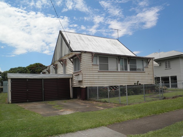

This is an image of the local heritage place known as Robinson Farmhouse
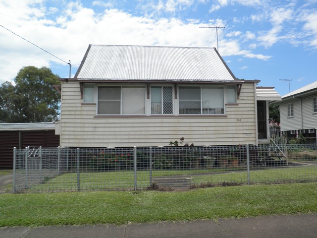
This is an image of the local heritage place known as Robinson Farmhouse
Robinson Farmhouse
Addresses
Type of place
House, Farm
Period
Victorian 1860-1890
Style
Queenslander
This is the oldest residence in the Banyo/Nudgee area. The four-room cottage was built in 1882 for farmer William Bulcock Robinson. Until the development of Banyo as a post war suburb, this house was one of the few residences in this sparsely settled part of Banyo. The old farmhouse is a local landmark and as such, members of the local community identified it in 2000 for inclusion in the district’s first heritage trail.
Lot plan
L6_RP64619
Key dates
Local Heritage Place Since —
Date of Citation —
Construction
Roof: Corrugated iron;Walls: Timber
People/associations
Robinson family (Occupant)Criterion for listing
(A) Historical; (B) Rarity; (C) Scientific; (H) Historical associationInteractive mapping
Lot plan
L6_RP64619
Key dates
Local Heritage Place Since —
Date of Citation —
Construction
Roof: Corrugated iron;Walls: Timber
People/associations
Robinson family (Occupant)Criterion for listing
(A) Historical; (B) Rarity; (C) Scientific; (H) Historical associationInteractive mapping
History
Banyo was originally part of the Nudgee District. Freehold land went on sale in the area in the 1860s. The property at 302 St. Vincent’s Road was originally part of 26 acres and 32 perches of land purchased by Brisbane resident John Kingsford on 9 September 1863. He paid ₤26.4.0 for the land described as Portion 210. The Catholic Church under the leadership of Bishop James Quinn (later O’Quinn) became a major local landholder with property that extended down to Nudgee Beach. The Church opened St. Vincent’s Orphanage and its Nudgee Cemetery in 1867.
Another major local landowner was the Robinson family. The large Robinson family held farms throughout Banyo, Virginia, Geebung and Aspley. Robinson Roads East and West are named after the family. In Banyo, this family owned land that was downhill from the Orphanage and Cemetery, in the area dominated by Beehive Hill (now the Australian Catholic University site). William Bulcock Robinson bought Portion 210 on 27 August 1880. He subsequently subdivided the land, retaining Subdivision A. He received a new title deed for this 18 acre, 2 roods and 28.1 perch block of land on 6 July 1882.
On 10 May 1882, the Sandgate Railway opened though no stop or siding was built at Banyo. Instead, the railway station for the entire district was placed at Railway Parade, Nudgee. Thus a small township grew around this station whereas the lower area where the railway crossed St. Vincent’s Road remained sparsely settled. The rail crossing was known locally as Clapham Junction.
Dairy farmer William B. Robinson built this modest cottage along the road to St. Vincent’s Orphanage around 1882. William B. Robinson is listed in the 1883-84 edition of the Queensland Post Office Directories as living in nearby German Station (now Nundah). So the small residence may have been used as temporary accommodation when he grazed his dairy herd on this, his outlying property in the Nudgee District. William B. Robinson first appears as a resident in the Nudgee District in 1889 edition of the Queensland Post Office Directories.
This small residence appears to be of an earlier c1860s style, so the cottage may have been relocated to Subdivision A of Portion 210 from elsewhere in Brisbane. It was possibly the first house constructed in this part of Banyo. It remains the earliest house to be found in the suburb. It was built as a farmhouse using local, bush timber. The house stumps were cut from local trees, and rough-edged timber hewn by an axe, adze or saw was used to construct the four-roomed cottage. The roof trusses were made from tea tree lumber. Initially the farmhouse roof was covered with timber shingles but later these were replaced by galvanised iron sheeting. As was standard practice, a detached kitchen was constructed at the rear of the cottage. Open verandahs (now enclosed) were placed at the front and the back of the cottage.
In 1912, a railway station was built at the Clapham Junction crossing and the Railway Department named the station ‘BANYO’. This was supposedly an Aboriginal word for ridge. The station prompted growth and development though this was concentrated on the northern side of the rail line and not near the old Robinson farmhouse. A small shopping precinct developed around the intersection of Royal Parade and St. Vincent’s Road. A School of Arts (later the Banyo Memorial Hall) was constructed adjacent to this intersection in 1925. In 1929, St. Oswald’s Anglican Church opened in Victoria (now Froude) Street. A Baptist Church was constructed in Hartley Street in 1930.
It was not until the Robinson family created the Robinson’s Paddock Estate in 1928 that the area around the old farmhouse began to urbanise. This Estate created Paradise and Langdon Streets and Redhill Road, with the first auction held on 15 September 1928. Part of the Robinson family land between St. Vincent’s Road, Tufnell Road and the rail line became public space (now Banyo Memorial Park). William Bulcock Robinson died on 19 May 1930 and his estate passed to the state government’s Queensland Trustees Limited. By 1946, the former Robinson farmhouse still remained fairly isolated as there had been little development in this part of Banyo during the Interwar period. Banyo remained a semi-rural area, dominated by fruit (particularly pineapple) farms.
Henry Daniel Sherratt and Pearl Pearce purchased the property on 28 September 1949 after Pearl Pearce’s parents had been renting the farmhouse from the Queensland Trustees Limited since 1931. The Sherratt family continue to own and occupy the property. A garage was added to the property in 1956.
In 2000, a group of community members, who comprised the BANGEE Festival Committee, identified 302 St. Vincent’s Road as a local heritage place. They entered this residence as Location 22 in their publication BANYO-NUDGEE Heritage Trail.
Description
The post-war 2-car garage has no heritage significance.
Statement of significance
Relevant assessment criteria
This is a place of local heritage significance and meets one or more of the local heritage criteria under the Heritage planning scheme policy of the Brisbane City Plan 2014. It is significant because:
References
-
Bangee Festival Committee, BANYO-NUDGEE Heritage Trail – a pictorial history of Banyo, Nudgee, Nudgee Beach, Virginia and Northgate East, (Banyo: Bangee Festival Committee, 2000)
-
Brisbane City Council, 1946 & 2009 aerial photographs
-
Brisbane City Council, post-1945 building application cards
-
Department of Natural Resources, Property title deeds and other documents
-
John Oxley Library, Brisbane Estate Maps collection
-
Queensland Post Office Directories, 1868-1949
Citation prepared by — Brisbane City Council (page revised September 2020)