Addresses
Type of place
House
Period
Federation 1890-1914
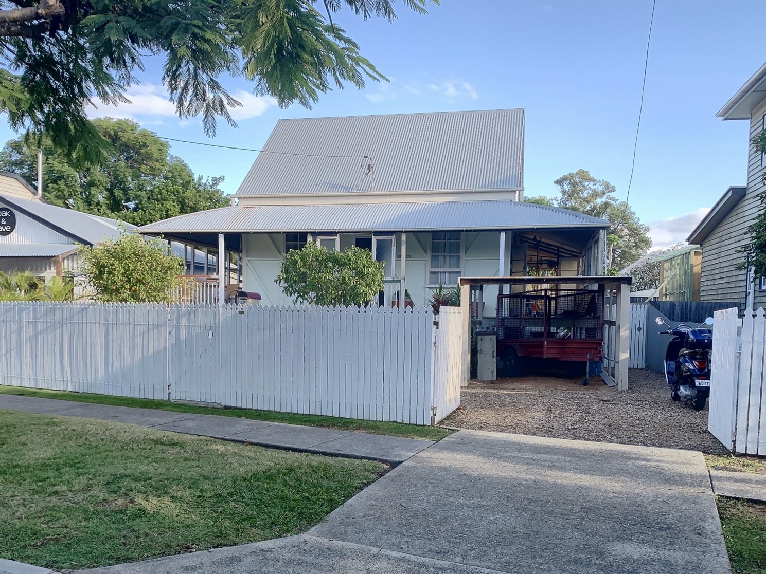

This is an image of the local heritage place known as Carrick
Carrick
Addresses
Type of place
House
Period
Federation 1890-1914
Built by 1900 for a retired farmer, David England, Carrick is an unusual modest scale residence constructed in Sandgate at the turn of the 20th Century. Setback along the main road away from the foreshore, Carrick is distinctive in demonstrating a different housing style of the period separate from the larger, more finely detailed houses in the Sandgate area. As a result, Carrick is a good representative example of modest housing built in Brisbane in the late 19th and early 20th Century.
Lot plan
L3_RP71669
Key dates
Local Heritage Place Since —
Date of Citation —
Date of Information —
Criterion for listing
(A) Historical; (D) RepresentativeInteractive mapping
Lot plan
L3_RP71669
Key dates
Local Heritage Place Since —
Date of Citation —
Date of Information —
Criterion for listing
(A) Historical; (D) RepresentativeInteractive mapping
History
A history of Sandgate
Sandgate, including the suburb of Shorncliffe, is located 17 kilometres from central Brisbane. The first land sales in the Sandgate area occurred during the 1850s and much of the early development centred on the area now known as Shorncliffe. On 29 April 1880, Sandgate was declared a constituted municipality. During the 1880s, the area around Pier Avenue and Yundah Street became the town’s communal and civic centre. The first Town Hall, constructed in 1882, the Court House, and the first two police stations were located in this area.
From the 1880s onwards, Sandgate became increasingly popular as a residential and seaside resort town. The opening of the train line to Brisbane in 1882 (extended to Shorncliffe in 1897) and the construction of the Sandgate Pier boosted the development of Sandgate. The train line to Sandgate was the first suburban line built solely for passengers in the Brisbane area. The train line provided a quick and efficient service for the growing number of residents commuting to Brisbane, and holidaymakers and day-trippers. Numerous attractions catering for visitors were also developed around this time. For example, separate bathing areas, dressing sheds, a caretaker’s cottage, office and licensed area were built close to the already established Sandgate Pier. In the 1930s, an enclosed area protected by railway lines, a shark net and stone wall was constructed as a shark-proof swimming enclosure lit at night. Additionally, Flinders Parade (then known as Brighton Esplanade), between First Avenue and Gladstone Street (now Twelfth Avenue), was dotted with cafes, refreshment rooms, flats and boarding houses. Attractions on the foreshores included sand-garden competitions, donkey, goat and gig rides, canoe hire and a miniature railway.
In 1910, a fire destroyed the original Sandgate Town Hall. Subsequently, a new Town Hall opened on Deagon Street (now Brighton Road) in 1912. This opening of the new Town Hall, alongside the relocation of Sandgate Rail Station to its current site in 1911, marked a shift in the location of Sandgate’s town centre away from the Shorncliffe area to the vicinity of the present-day Rainbow Street, Brighton Road and Bowser Parade. This area proved to be more accessible for neighbouring Deagon and Brighton residents.
The 1920s saw another period of prosperity for Sandgate. In 1925, Sandgate became a founding ward of the newly created Greater Brisbane City Council. While Shorncliffe continued to be a popular destination, the Sandgate and Brighton foreshores also drew crowds of holidaymakers. However, the building of the Hornibrook Highway Bridge in 1935 brought mixed blessings for Sandgate. This was because while the highway brought more passing trade to the area, it also enabled visitors to travel further north, typically by public transport, to the Redcliffe Peninsula for holidays rather than vacationing in Sandgate as had traditionally been the case. After the Second World War, increased car ownership also led to a further decline in the area's popularity as people were able to travel further beyond Brisbane’s city limits for a holiday. Car ownership also brought the expansion of Brighton, Deagon and Nashville as outer suburbs became more attractive.
The development of Rainbow Street, Sandgate
The development of Rainbow Street dated to the 1880s when numerous commercial premises housing tradespeople were established. Trades and services included plumbing, painting, building and blacksmithing, and a tailor, draper, and coffee stall. By 1893, there was a phonograph parlour opposite the Post Office, while by the turn of the 20th Century C. Shepherds had opened an aerated waters factory on Rainbow Street. In 1891, St Margaret’s Anglican Church was opened on Rainbow Street. The church was later converted to a rectory, and a new Spanish Mission-style church opened on the same site in 1927. On the site of St Margaret’s, there is a monument to Robert Atkin, a member of the Queensland legislative assembly, which was erected in 1872. In 1874, Sandgate State School was established on its current site on Rainbow Street. Later developments on Rainbow Street included the relocation of Sandgate railway station to its current location in 1911.
The intersection of Rainbow and Board Streets represents the non-urban character of Sandgate that existed before the Second World War. This wide intersection is bordered by a park, several examples of early houses of varying scale and a rare pre-Second World War petrol station. By 1936, the Hornibrook Highway Bus Service had opened a bus depot and office on the corner of Rainbow Street and Knox Street. This bus service provided a service from Sandgate Central railway station across the Hornibrook Highway bridge to the Redcliffe peninsula.
The construction of Carrick, 225 Rainbow Street
Built by 1900 for David England, a retired farmer from South Pine, Carrick is a small-scale, single-storey low-set timber house with a simple, steep and gabled metal roof with a separate U-shaped verandah roof. England purchased the site on which Carrick resides to build a retirement property in Sandgate, a popular seaside town. Initially, in 1895, England purchased subdivisions four, five, 36, and 37 of allotment four of section 14. Subsequently, in 1898, England purchased subdivisions three and 38 to the east of his earlier investment. Carrick was initially built in the middle of subdivisions three, four, and five facing Rainbow Street. While located away from the foreshore, Carrick’s location at the eastern end of Rainbow Street placed England, and his wife Jane, within walking distance of the beach at Shorncliffe and Sandgate Pier.
England had been a well-known farmer in South Pine from the 1870s onwards. As The Queenslander reflected in a 1921 article about his son, David, he came ‘from a well-known South Pine family, noted for breeding good draught horses.’ As well as being a farmer, England served two terms as a Caboolture Divisional Board member during the 1880s. The Caboolture Divisional Board covered the present-day areas of Caboolture, Kilcoy, Landsborough, Pine Rivers, Redcliffe, and part of Maroochy. The Pine Rivers Divisional Board was created in 1888.
After England died in 1907, the land and Carrick were transferred to his widow, Jane. Jane remained living at the residence until her death in 1933, when Carrick passed to her daughter Emma Harris. After passing through several subsequent owners, from 1947 onwards, the land was further subdivided, first by Annie Woodhall and then by Philip and Elizabeth Lischeld. In 1950, the Lischeld’s moved Carrick to its current location. In late-1951, subdivision three and resubdivision one of subdivision four, on which Carrick was now located, was transferred to Violet and Francis Brumfield, who enclosed the verandah in 1959. Later, in 1959, the front verandah was enclosed by the Brumfield’s.
Description
Carrick is an intact example of a modest, low-set colonial period residence built in the early 20th Century. Many of the hallmark elements of the Colonial Gable and Pyramid architectural styles remain, including a gable roof core, a U-shaped verandah with a convex roof, dowel balustrading and stop-chamfered posts, exposed wall framing with timber cladding, and double-hung sash windows. A simple timber picket fence and low-lying vegetation make the residence highly visible from the street.
General description
Carrick is a small-scale single-storey residence with a metal-sheeted gable roof, narrow eaves, and a stepped, gently curved convex roof over a now enclosed U-shaped verandah. External walls use fibre cement sheeting and cover strips as the main cladding material. Inside the verandah, external walls of the building's core are exposed timber stud framing, with timber cladding behind. To the rear, a gable-roofed kitchen wing projects from the core of the building.
The U-shaped verandah is now enclosed by fibre cement sheeting and window and door arrangements. However, the original two-rail dowel balustrade and stop-chamfered posts remain exposed to the interior of the sheet cladding.
Some original multi-paned timber double-hung sash windows, with simple timber frames and sills, also remain.
Carrick sits on concrete stumps with ant caps, and the subfloor space is enclosed with timber battens.
External additions to the exterior of Carrick, include metal-sheeted gable ends, contemporary window and door arrangements, a garage and gravel driveway, and front stairs, including a basic balustrade and concrete pad.
From published images viewed on 7 April 2021, the interior is relatively intact, with some cosmetic and stylistic changes. Of note are the single-skin walls with a combination of tongue-and-groove and vertical join timber linings, and tongue-and-groove ceiling linings. The original timber scotia and picture rails remain.
Some breezeway panels above internal doors remain.
Changes to the interior include a non-original kitchen and bathroom, and addition of floor linings.
Carrick is set back further from the street frontage than the surrounding properties. At the front of the property, a low-lying timber picket fence separates the front yard from the public footpath.
Minimal planting and garden beds, and an open lawn provide the front setting.
The rear of the property has planting, garden beds and open lawn spaces similar to the front.
A gravel driveway along the western boundary leads to the non-original carport.
There are significant views to the place from Rainbow Street.
Significant features
Features of cultural heritage significance include:
- Original built form and composition, including:
- Built form and composition consistent with a colonial-style home of this period
- Scale and form
- Low-set undercroft space
- Raised on stumps with ant caps
- Gable roof in metal sheeting
- U-shaped verandah
- Stepped, curved convex roof over verandah
- Kitchen wing to rear.
- External design details, including:
- Exposed timber stud framing
- Single-skin horizontal board cladding
- Two-rail dowel balustrades
- Stop-chamfered posts
- Multi-paned, timber double-hung sash windows including timber frames and sills.
- Interior elements and design details, including:
- Tongue-and-groove timber wall linings
- Vertical join wall linings
- Tongue-and-groove ceiling linings
- Timber scotia
- Timber picture rails
- Breezeway panels.
- Grounds and setting, including:
- Setback from streetscape
- Unobstructed views to the place from the street.
- Views to and from the place
Non-significant features
Non-significant features include:
- Fibre cement sheeting
- Metal sheeting on gable ends
- Non-original window and door arrangements
- Garage
- Gravel driveway
- Front stairs, including balustrade
- Non-original kitchen and bathroom
- Garden bed edges and planting.
Statement of significance
Relevant assessment criteria
This is a place of local heritage significance and meets one or more of the local heritage criteria under the Heritage planning scheme policy of the Brisbane City Plan 2014. It is significant because:
Supporting documents
Citation prepared by — Brisbane City Council (page revised September 2023)