Addresses
Type of place
Natural feature
Period
Pre-convict settlement to 1824
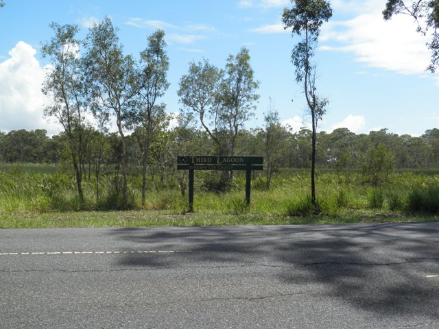

This is an image of the local heritage place known as Sandgate Third Lagoon
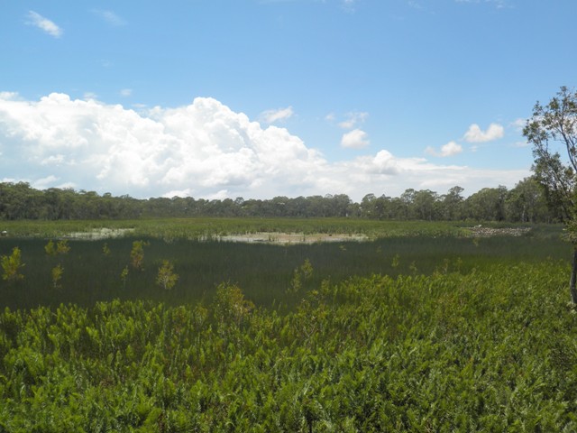
This is an image of the local heritage place known as Sandgate Third Lagoon 2
Sandgate Third Lagoon
Addresses
Type of place
Natural feature
Period
Pre-convict settlement to 1824
Third Lagoon, also known as Bungwald Lagoon, is a reeded freshwater lagoon which forms part of a complex ecosystem of wetland parks in Brisbane’s east. Following land sales in 1853, settlement developed around the nearby Einbumpin and Dowse lagoons. However, Third Lagoon was generally preserved as a wilderness, apart from some use as hunting grounds for wild ducks and hares. Harbouring a rich diversity of habitats, plants and animals, Third Lagoon is popular as a wildlife reserve offering a walking track and picnic areas scattered across the lightly timbered surrounds. The lagoon is an important and distinctive visual element in the surrounding landscape, providing a scenic focus for the nearby residential properties and expansive views.
Also known as
Bungwald Lagoon
Lot plan
L269_SL11319
Key dates
Local Heritage Place Since —
Date of Citation —
Criterion for listing
(A) Historical; (B) Rarity; (E) Aesthetic; (G) SocialInteractive mapping
Also known as
Bungwald Lagoon
Lot plan
L269_SL11319
Key dates
Local Heritage Place Since —
Date of Citation —
Criterion for listing
(A) Historical; (B) Rarity; (E) Aesthetic; (G) SocialInteractive mapping
History
The bayside suburb of Sandgate was known to the indigenous people as “Moora” or “Warra”, meaning open sheet of water. The area offered them abundant food resources in the lagoons, mangroves and bushlands. Sandgate has undergone several periods of accelerated development since European colonists first accesses Moreton Bay in 1842. The first land sales took place in 1853 and settlers soon moved into the area, taking up land on traditional Aboriginal camp sites located in the open woodlands, surrounding the lagoons, swamps and waterholes and along the sandy foreshores of the bay. The lagoons, long a haven for wildlife, became a popular spot for hunting, fishing and duck shooting. Scenic natural features dominating the landscape, the lagoons influenced the pattern of settlement of Sandgate. The town centre established itself adjacent to Einbunpin Lagoon and development spread around this lagoon and across and around Dowse Lagoon. The Third Lagoon precinct has been settled as a residential area.
Third Lagoon (also known as Bungwald Lagoon) is a wetland park within a group of wetland parks that form Deagon Wetlands, which includes a number of smaller wetland parks – Deagon Wetlands Reserve, Third Lagoon, Dowse Lagoon, Einbunpin Lagoon and Brighton Wetlands. These wetlands belong to a string of coastal wetlands in Brisbane’s east and lie on old alluvial plains. These soils became waterlogged after rain, forming swamps and lagoons. The lagoons are not connected by underground aquifers, as was earlier supposed, but are individually fed by rain and run-off. It is claimed that the Aborigines in the area crushed the root of the bungwald fern to make a paste for cooking and with this association the Lagoon also became known as Bungwald Lagoon.
Apart from being a resource for the hunting of wild ducks and hares, Third Lagoon has generally survived since European settlement as a wilderness, consisting mainly of reed beds surrounded by melaleucas and eucalypts. The Lagoon earlier extended from the foothills of land adjacent to Baskerville Street and continued for some distance south towards the Deagon Racecourse. The land was waterlogged for most of the time. With the construction of Bracken Ridge Road, a barrier was formed which retained the waters in the Lagoon. The Lagoon Reserve has been diminished over the years by road construction and the Nashville Primary School now occupies a portion of the north corner.
Harbouring a rich diversity of habitats, plants and animals, Third Lagoon is popular as a wildlife reserve, with a circuit track offering walking access to the edges of the Lagoon and picnic areas scattered across the lightly timbered surrounds.
An adventure-based learning facility developed by the Jabiru Community Youth and Children’s Services was devastated by fire in the late 1990s. The Lagoon area includes a native food trail. Part of the reserve was named Peace Park on 6 August 1984, the 39th anniversary of the dropping of the first atomic bomb on Hiroshima.
Description
The Third Lagoon Reserve (also known as Bungwald Lagoon) is a large irregular wedge of land bounded by Baskerville Street, Bracken Ridge Road, Barfoot and Douglas Streets, Brighton. A portion to the north corner of the reserve is excised for the Nashville Primary School and the Deagon Deviation cuts through the west portion of the reserve, stranding Taraubul Park as an island to the west. Taraubul Park accommodates sportsfields and areas of bushland.
The Lagoon area is a swampy expanse of grasses and reeds, ringed by a variety of vegetation types and densities. The open areas scattered with eucalypts and melaleucas contrast with the areas of more dense and lush vegetation. The Lagoon provides a habitat for a range of birds and other wildlife.
An open grassed and lightly treed strip along Baskerville Street, known as Peace Park, accommodates a scatter of picnic tables and play areas. A circuit path runs around the lagoon, with a timber boardwalk section terminating about midway along Bracken Ridge Road, opposite an entrance to Deagon Wetlands. Interpretive signage stands at various points along the circuit path.
A small rectangular freestanding timber hut on concrete stumps stands southeast of Nashville Primary School and accommodates Artesanos, the Bayside Arts Directory.
The lagoons of Sandgate – Einbunpin, Dowse and Third – are a distinctive and recognisable landscape feature of the district, providing a scenic backdrop to the townscape and a habitat for wildlife. Only Third Lagoon remains in an essentially natural condition. Third Lagoon is important for the expansive views afforded across the wide grassed and reeded area. Part of an important ecosystem of wetlands, Third Lagoon is threatened by the encroaching urban fabric and consequent toxic run-off.
Statement of significance
Relevant assessment criteria
This is a place of local heritage significance and meets one or more of the local heritage criteria under the Heritage planning scheme policy of the Brisbane City Plan 2014. It is significant because:
References
-
Fisher, Rod, Spring Hill Heritage Tour: St Pauls to Gregory Terrace, Kelvin Grove: Brisbane History Group, 1993
-
Brisbane History Group, Brisbane: Corridors of Power, Brisbane History Group Papers No. 15, Brisbane History Group, Brisbane, 1997
-
Brisbane City Council Heritage Unit, Sandgate by the Sea, Heritage Trail Series 12, Sandgate Heritage Trail
-
McDonald, Maree, Sandgate Tides of Change, Reepete Publishing, Brisbane, 1997
-
Sandgate & District Historical Society and Museum, A Walk around Sandgate, Shorncliffe – Sandgate Tour Vol. 1, Sandgate & District Historical Society and Museum, Sandgate, 1993
Citation prepared by — Brisbane City Council (page revised September 2020)