Addresses
Type of place
House, Dairy
Period
Interwar 1919-1939
Style
Queenslander
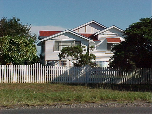

This is an image of the local heritage place known as Elliot Farmhouse
Elliot Farmhouse
Addresses
Type of place
House, Dairy
Period
Interwar 1919-1939
Style
Queenslander
This interwar farmhouse is typical of the residences on the numerous small farms that comprised Brisbane’s outer northern districts’ green belt prior to World War Two. Originally this property was part of prominent local farmer Robert Graham’s dairy. The family subdivided the dairy in 1910 and so began the trend towards small farming that would later characterise the Aspley District.
Also known as
Graham Farmhouse
Lot plan
L3_RP26029
Key dates
Local Heritage Place Since —
Date of Citation —
Construction
Roof: Corrugated iron;Walls: Timber
People/associations
Graham family (Occupant)Criterion for listing
(A) Historical; (H) Historical associationInteractive mapping
Also known as
Graham Farmhouse
Lot plan
L3_RP26029
Key dates
Local Heritage Place Since —
Date of Citation —
Construction
Roof: Corrugated iron;Walls: Timber
People/associations
Graham family (Occupant)Criterion for listing
(A) Historical; (H) Historical associationInteractive mapping
History
The first land sales for the Aspley district were held in Sydney in February 1857. On 27 September 1860, John, Henry and Samuel Raynbird, of Brisbane, purchased Portions 22 and 26 (Parish of Nundah), adjoining Cabbage Tree Creek. The Raynbird brothers paid £107 for Portion 22, which comprised 107 acres of land that sloped down to the banks of the watercourse that was also known by the name of Tighgum Creek. After the Raynbirds bought Portion 152, situated on the other side of Graham Road, on 26 April 1865, they became major landowners in the Aspley district.
Mary Anne Ramsay, the wife of Francis Ramsay of Brisbane, assumed ownership of Portion 22 on 27 March 1876. The land was then transferred to dairy farmer Robert Graham, after whom Graham Road is named, on 29 August 1882. From the 1890s through to the 1920s, a second wave of development began to occur in the Aspley district as a result of the opening of the J.C. Hutton smallgoods factory on Zillmere Road in 1888. Many of the original large land holdings were broken-up and converted into small farming allotments for dairies, piggeries or fruit, particularly pineapple, growing. This would lead to a farmland Green Belt that that encircled the older Brisbane suburbs, with their housing estates, tramlines and other elements of urban living.
The land along Graham Road was the first large farm to be subdivided and as such it led to “the start of the small farmer in Aspley”. Graham passed the property to his daughter-in-law Ethel Isabella Graham, the wife of William Graham, on 18 July 1910. William had been born in 1877 and he became a dairyman like his father. The Graham family subdivided the land into nine allotments, numbered 1 to 8 and 3A, all of which were suitable for small farming. The first of these, subdivision 2, comprising 10 acres, was sold to William Mossman Thomson, on 8 February 1916.
On 13 March 1918, two spinsters, Alice and May Pittman, obtained the title deed to subdivision 3 of Portion 22. This narrow block, with its 4 acres of farmland, became the property at 112 Graham Road. The Pittman sisters only held the land for five years, before transferring it to Frank Anderson Elliott and his wife, Ethel Maude Elliott, on 25 July 1923. Frank A. Elliott’s name first appears in the Queensland Post Office Directories for the Aspley district in the 1924-25 edition. The farmhouse at 112 Graham Road was built circa. 1924. The Elliotts owned the land for six years before they passed it onto a widow, Jane Thompson Clark, on 6 June 1929.
The property returned to the ownership of the Graham family when William Graham received the title deed on 10 April 1930. He held the land for eight years before transferring the property to William Alfred Bristead and his wife Mary Johnstone Bristead, on 22 July 1938. The Bristeads acquisition of the farm was funded through a mortgage, which they took out on the day of purchase, through a widow, Isobel Margaret Ross. But the Bristeads did not hold their property for long, before passing it to William Edward Lovell on 24 April 1940. Lovell also mortgaged the property to pay for his purchase, with the financier being the Brisbane Permanent Building and Banking Company. Marie Therese Williams received the title deed on 10 June 1940. When she died on 20 July 1941, her estate passed to the executor of her will, James William Parsons. But then James Parsons died on 15 April 1943, and the farm passed into the hands of his widow, Amy Parsons.
On 18 April 1947, Frederick Thurlow became the next owner of 112 Graham Road. He also mortgaged the farm on the day of purchase, obtaining his finance through the British, Scottish and Australian Bank Limited. Thurlow’s connection with the property was also short-lived, for he transferred the farm to Beryl Isobel Biddle and Colin John Thomas Smith on 12 January 1949. On this date, Biddle and Smith mortgaged the farmland through the Commercial Bank of Australia Limited (CBA).
Claude Arnold Colley took control of the property on 4 July 1949. He also took over Biddle and Smith’s CBA mortgage. From the Bristead’s purchase of the property in 1938 through the various ownership changes through to 1955, the farm may have been used as a rental property as none of the names of these title deed holders appear in the Queensland Post Office Directories.
The farm at 112 Graham Road was unusual, in that even by 2002 it had retained its original 1910 subdivision boundaries, and had not lost any land to the encroaching housing estates that overran this part of Aspley from the 1970s through to the 1990s.
Description
The residence sited along Graham Road is a timber house, asymmetrical in design with timber boards external walls and a series of corrugated iron gable roofs.
The house has a three-gable street frontage intersected by a transverse gable at the rear. The front gables are wide with a fairly low-pitch and have a half-timbered infill similar in fashion to dwellings of the same period.
The house is high-set, its undercroft in-filled with timber battening. The front steps run parallel along the front to the gabled porch now enclosed. A traditional “tin and timber” sunhood shades the window to the narrower street-facing gables located to the right of the house.
A picket fence separates the house from the street. The mature trees in the front garden enhance the appearance of the site within the streetscape.
Statement of significance
Relevant assessment criteria
This is a place of local heritage significance and meets one or more of the local heritage criteria under the Heritage planning scheme policy of the Brisbane City Plan 2014. It is significant because:
References
-
Brisbane City Council, Properties on the Web, website
-
Brisbane City Council, 1946 aerial photographs.
-
Brisbane City Council’s Central Library, Local History files – Zillmere – Geebung – Aspley – Bald Hills.
-
Brisbane City Council’s Heritage Unit, A History of Extractive Mining Industries of the Brisbane Area, (Brisbane: Heritage Unit, 1990s).
-
Department of Natural Resources, Queensland Certificates of title and other records.
-
John Oxley Library, Parish of Nundah, County of Stanley, L.A.D. of Brisbane map, (1899 land grant map).
-
Queensland Post Office Directories, 1868-1949
-
Teague, D.R., The History of Aspley, (Brisbane: Colonial Press, 1972).
Citation prepared by — Brisbane City Council (page revised September 2020)