Addresses
Type of place
House
Period
World War I 1914-1918
Style
Bungalow
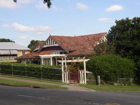

This is an image of the local heritage place known as Residence
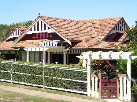
This is an image of the local heritage place known as Residence
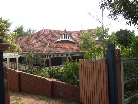
This is an image of the local heritage place known as Residence
71 Oriel Road, Clayfield
Addresses
Type of place
House
Period
World War I 1914-1918
Style
Bungalow
These three allotments were acquired by Albion pharmacist George Frederick Haenke in January 1914. Plans for the house to be built on the land were drawn up by his older brother, Ipswich architect Martin William Haenke. Martin Haenke practised as an architect during the early years of the 20th century, but was also involved in the colliery industry in Ipswich for most of his life. Martin Haenke called tenders for the erection of his brother’s house in December 1914. George Haenke married Elsie May McCaskie in March 1915, and the couple presumably occupied the residence soon after. The Haenkes spent their married life at this residence, title passing to Elsie May in 1966 after the death of George. There have been a number of subsequent owners of the property.
Lot plan
L26_RP34386; L24_RP34386; L25_RP34386
Key dates
Local Heritage Place Since —
Date of Citation —
Construction
Roof: Terracotta tile;Walls: Timber
People/associations
Martin William Haenke (Architect)Criterion for listing
(A) Historical; (E) Aesthetic; (H) Historical associationInteractive mapping
History
Clayfield is a residential suburb of Brisbane, located 6km north-east of central Brisbane. The suburb’s name is derived from the fine white-grey sedimentary clay that was mined in Albion, between Morgan and Sykes Streets, from the 1860s. This clay was used in the brickworks, which was located between Oriel Road and Reeve Street near Sandgate Road, and came to be known as the “clay fields”. The Albion brickworks were instrumental in the residential development of inner-north Brisbane.
The North Coast railway opened in 1882, with a line running from Eagle Junction to Ascot via Clayfield. The Eagle Junction Post Office then opened in 1883. A tram line was run along Sandgate Road from 1901, from Breakfast Creek to Wagner Street, further opening up the suburb to residential development.
In the late 1880s several large residences were constructed and Clayfield began to rival Hamilton as the choice, exclusive suburb of north Brisbane due to its proximity to the city centre and the racecourse. This is reflected in the private schools which were introduced to the suburb in the late nineteenth century including Brisbane Boys College (Clayfield College – the boys school was later moved to Toowong in 1931 and the school became a girls college for many years), St Rita’s Girls College, St Michael’s College and St Mark’s College (all of which were developed by their resident churches).
With the growing popularity of Clayfield as an exclusive suburb, and emerging development opportunities after the closure of the brickworks, the population grew significantly from 1911 to 2011:
Census Date Population
1911 2049
1976 9525
2001 9010
2006 9534
2011 10,006
The suburb boasts a number of outstanding heritage houses, built in the late nineteenth and early twentieth centuries.
The original land for this site was part of portion 89, which was purchased by James Sutherland in 1858, then sold to Edward Blundell who had also purchased portion 88. John Blanc owned portions 88, 89 & 90 in 1876 and subsequently subdivided the land into 16 perch blocks and sold it from 1887. The Queensland Deposit Bank and Building Society purchased much of the subdivided land that year, with the remainder sold in double (32 perch lots) in 1888 and 1889.
Charles Stafford Miles purchased 2 acres 32 perches from the Queensland Deposit Bank and Charles Fletcher purchased two subdivisions (subs. 24-26) in November 1913, but sold it two months later to George Haenke in January 1914. Charles Fletcher did not live on the property but went on to be a law clerk living in Franz Road.
George Haenke was the son of Johann Wilhelm “William” Haenke, a German blacksmith who had migrated to Australia in the 1860s and married another German immigrant, Fredericke Christina Louisa Muller, in 1869. George and his brothers all became well-respected professionals – John Martyn Haenke was an architect based in Toowoomba and Martin William Haenke was a well-respected Ipswich architect and business-man. George Haenke ran a successful pharmacy in Albion and married socialite Elsie McCaskie in March 1915.
Following the purchase of the land, George Haenke employed his brother Martin Haenke to design the house for himself and his then-fiancé Elsie. Tenders were put out for contractors in December 1914 with plans available to be viewed at the Albion pharmacy. Martin Haenke was George’s older brother born in 1875 who was articled to Ipswich architect Henry E. Wyman in 1891. Martin exhibited drawings at the National Association of Queensland exhibition and won a prize for ‘illumination’ at the Ipswich Show. He worked in Melbourne with architects Lloyd, Taylor and Fitts. He began his own practice in Ipswich as “architect and electrician” and by 1916 was well-known featuring in an illustrated poem in the Sunday Truth – not only as a well-known, successful architect and planner but also a coal prospector. He acquired interests in the Rhondda Colliery and other mines at Bundamba, Rosewood, the Darling Downs and Central Queensland. Watson & Mackay state this “his architectural work at the turn of the century is significant as a local adaptation of the European Art Nouveau style, often using extreme asymmetry.” George Haenke’s house in Oriel Road displays these characteristics.
The house construction was completed by late 1915, as George and Elsie Haenke are registered as living in Oriel Street in the 1916 Queensland Electoral Roll and are recorded as receiving mail there in 1917. The house remained the family home until Elsie’s ill-health forced the sale of the home in 1976. George had passed away ten years earlier in April 1966.
The house has changed ownership numerous times in the last 40 years. The property has increased significantly in value in recent years due to its prominent location and sizable yard, and has remained relatively unchanged since 1927.
Description
The building features a hipped and gabled terracotta tiled-roof, with two street facing gables positioned over the front verandah and original drawing room, which features a projecting bay window.
The verandah is wide, with intact paired timber posts and ornamental timber valance.
The architectural plans for this building feature details of the internal timber fretwork, some of which is still intact (see images below).
Evidence of the inter-war renovations are still evident, with the parquetry-flooring, detailed timber architraves around the doorways and windows, and ornate plaster ceilings still intact. The internal doors feature double doors with leadlight infill panels, and the bay window at the front of the house still features the original casement windows.
Statement of significance
Relevant assessment criteria
This is a place of local heritage significance and meets one or more of the local heritage criteria under the Heritage planning scheme policy of the Brisbane City Plan 2014. It is significant because:
References
-
Watson, Donald & Judith McKay, A Directory of Queensland Architects to 1940, UQ Library, 1984
-
Queensland Title Deeds
-
Queensland Electoral Rolls
-
Wise's Post Office Directories
-
Digitised newspapers and other records. http://trove.nla.gov.au/newspaper
-
Centre for the Government of Queensland, Queensland Places – Clayfield, http://queenslandplaces.com.au/clayfield (accessed 2 August 2017)
-
Brisbane City Council 1911 Contour Map
-
Brisbane City Council Detailed Plan No. 250 and associated surveyor notebooks
-
Brisbane City Council Properties on the Web
-
Maps (aerial and historical)
-
Judy Gale Rechner, Brisbane House Styles 1880 to 1940: a guide to the affordable house, Brisbane: Brisbane History Group Studies No. 2, 1998
-
Richard Apperly (et al), A Pictorial Guide to Identifying Australian architecture Sydney: Angus and Robertson, 1989
-
Conrad-Gargett Heritage Impact Report (2017)– original plan of building
Citation prepared by — Brisbane City Council (page revised September 2020)