Addresses
Type of place
House
Period
Victorian 1860-1890
Style
Queenslander
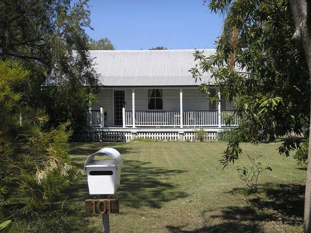

This is an image of the local heritage place known as Residence
101 Lynne Grove Avenue, Corinda
Addresses
Type of place
House
Period
Victorian 1860-1890
Style
Queenslander
From 1860 land sales had seen the gradual development of farms in the Corinda district with pioneer selectors in 1860s and 1870s growing maize, potatoes, bananas, cotton, sugar cane, and arrowroot. While the opening of the rail line in 1876 prompted subdivision and residential settlement, large areas of Corinda remained in use as farmlands into the twentieth century. Farmer Joseph Young and his wife Eliza owned the single acre on which this house was built from 1887 to 1931. The house was built some time between 1887 and 1891. In keeping with the gradual transformation of Corinda from farming land to residential suburb, the property was not subdivided until 1958.
Lot plan
L1_RP90707
Key dates
Local Heritage Place Since —
Date of Citation —
Construction
Roof: Corrugated iron;Walls: Timber
Criterion for listing
(A) HistoricalInteractive mapping
Lot plan
L1_RP90707
Key dates
Local Heritage Place Since —
Date of Citation —
Construction
Roof: Corrugated iron;Walls: Timber
Criterion for listing
(A) HistoricalInteractive mapping
History
The area from Chelmer to Corinda was known as “Boyland’s Pocket” in the 1850s, Captain Boyland having leased the area in 1851. In 1860 the new Queensland government opened up the district for selection, at a price of 1 pound per acre, resulting in the establishment of a number of farms ranging anywhere between 25 and 70 acres in size. Attempts were made by pioneer selectors during the 1860s and 1870s to produce maize, potatoes, bananas, cotton, sugar cane, and arrowroot. The opening of a railway bridge at Indooroopilly in 1876 reduced the isolation of the area, and allowed for increased subdivision. The first main wave occurred in the 1880s, a boom period for Brisbane. However, many of the allotments sold at this time remained vacant for years, and continued to be used for small farming operations. Later waves of building, occurring after each of the World Wars, gradually reduced the amount of farmland, and new housing continues to envelop those gracious older houses which once stood on acreage, surrounded by gardens.
In 1874, William Blandford owned 5 acres of portion 102. In 1887, 1 acre of this was sold to Eliza Maria Annie Young, wife of Joseph Grieve Young. She took out a mortgage for 50 pounds in 1888, and one for 30 pounds in 1892. For some reason the POD entries alternated between husband and wife. Mrs Joseph Young was first listed in the POD as living in Corinda in 1891, and she is also listed in the 1892, 1893, 1895-96, and the 1897-99 PODs. Meanwhile, Joseph Young, “farmer”, is listed in the 1892-93, 1894-95 and 1896-97 PODs. Joseph is first listed in the Oxley electoral role in 1893 as having a household on part of portion 102. It is likely that he was farming on nearby vacant land.
When Eliza died in 1931, the property was transferred to the Public Curator of Queensland. In 1946, it was transferred to Thomas Grieve Young. The acre was subdivided in 1958, and in 1965 the current 1 rood and 9.6 perches was sold to Brian and Lea Tate.
Statement of significance
Relevant assessment criteria
This is a place of local heritage significance and meets one or more of the local heritage criteria under the Heritage planning scheme policy of the Brisbane City Plan 2014. It is significant because:
References
-
Department of Natural Resources and Mines, Queensland Certificates of Title
-
Walter Taylor South Character and Heritage Study, BCC Heritage Unit, 1997
-
Queensland Post Office Directories
-
Queensland Electoral Rolls
-
Brisbane City Council Water Supply & Sewerage Detail Plans
-
McKellar's Map of Brisbane and Suburbs. Brisbane: Surveyor-General’s Office, 1895
Citation prepared by — Brisbane City Council (page revised June 2022)