Addresses
Type of place
Bridge, Reserve
Period
Interwar 1919-1939, Postwar 1945-1960
Style
Stripped Classical
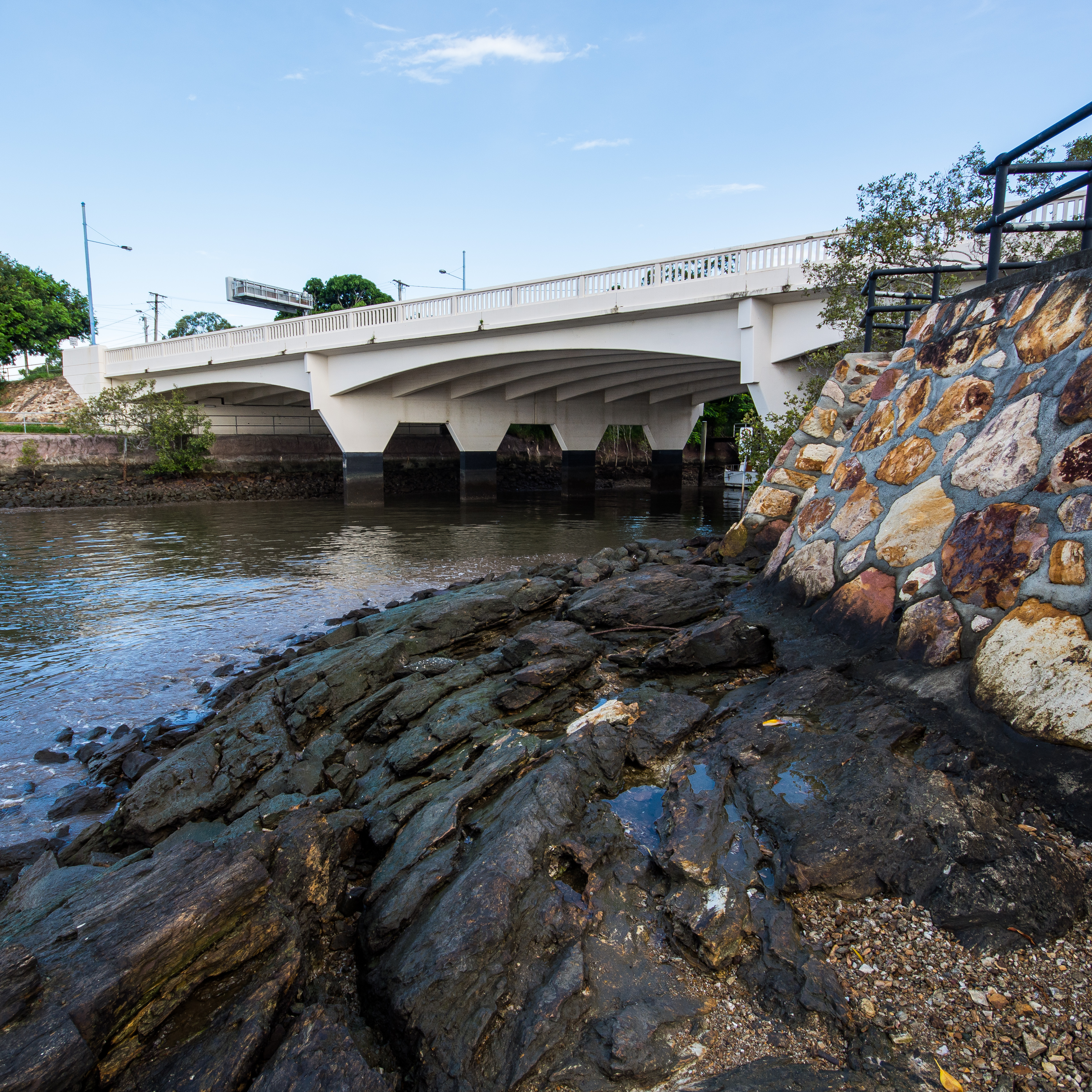

Canning Bridge & Reserve, viewed from the western 'side' of Norman Creek
This is an image of the local heritage place known as Canning Bridge & Reserve
Canning Bridge & Reserve
Addresses
Type of place
Bridge, Reserve
Period
Interwar 1919-1939, Postwar 1945-1960
Style
Stripped Classical
The Canning Bridge is important as a crossing that demonstrates the expansion of Brisbane’s eastern suburbs and demand for improved connections to them. The bridge is the fourth in this location since 1856. Largely unchanged since it was built, the bridge is a rare example of an intact concrete bridge from this time and demonstrates the principles of this type of structure. With its graceful arches and craftsmanship evident in the concrete balustrade, the bridge, together with the reserves and embankments that form its setting, is an important part of the streetscape and riverscape in this area.
Lot plan
L286_SL2560
Key dates
Local Heritage Place Since —
Date of Citation —
Construction
StructureCriterion for listing
(A) Historical; (B) Rarity; (D) Representative; (E) AestheticInteractive mapping
Lot plan
L286_SL2560
Key dates
Local Heritage Place Since —
Date of Citation —
Construction
StructureCriterion for listing
(A) Historical; (B) Rarity; (D) Representative; (E) AestheticInteractive mapping
History
Norman Creek was surveyed by James Warner in 1839. Before it was bridged, Norman Creek was a serious obstacle for transport. Access between the Norman Park area and the city required a lengthy detour through Stone’s Corner. The first bridge was erected by Captain Taylor Winship in 1856. Wynnum Road became the fastest route to Cleveland and so became known as the Cleveland Road until the 1950s. The second bridge was built further inland in 1870. The third bridge was opened by Governor Chermside in 1902. In July 1927, the small reserve on the river side of the bridge was gazetted for park purposes.
On 20th September 1950 tenders were called for the construction of a new bridge to replace the 1902 structure. An artist’s impression of the proposed bridge showed the structure as being identical to what would later be built, complete with landscaping and an outbound “FM” series tram. Titled “Norman Creek Bridge – 1951” it was signed by R.J. Drysdale. By 1954 the downstream section of the bridge was ready for traffic. During this time the transfer of tram tracks from the old bridge to the half-width of the new bridge was completed, with one track laid permanently in the roadway and one in a temporary position pending the construction of the second half of the bridge.
At the time of opening the deck carried central tram tracks with a vehicle lane and pedestrian path on each side. After the decommissioning of the tramway system in 1969 the bridge carried two vehicle lanes in each direction. This configuration remains along with the pedestrian path on each side.
In late 1956 a proposal was made to rename the Norman Creek Bridge. It was suggested that the bridge carry the name of Francis Joseph Canning, who for a period of twenty years occupied the office of President of the Council of Progress Associations in Brisbane. The proposal was accepted, and a plaque was prepared and placed on the bridge abutments.
Description
The Bridge
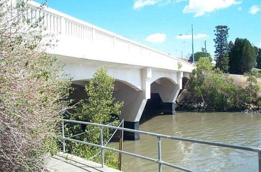
The Canning Bridge carries Lytton Road across Norman Creek, near its junction with the Brisbane River. The painted concrete bridge is highly visible from across the River in Merthyr Park and is a landmark on the River’s Humbug Reach.
The deck is supported on arched concrete ribs running parallel with the roadway. The arches spring from concrete abutments, which in turn, are each supported on a row of rectangular piers. These lines of support run, not perpendicular to the road, but are instead angled across the ribs to reflect the angle at which Norman Creek enters Brisbane River. The two centre abutments extend beyond the outermost arches, tapering and stepping outwards to form bracket-like supports to the edge of the road deck.
The edge of the deck forms a ledge and supports panels of painted concrete balustrade on each side of the bridge. The bridge is book-ended by rendered concrete abutments on each side of the creek. These project above the deck, forming a solid end panel to the balustrading and supporting a street light at each corner of the bridge. The panel on the southeast corner bears a bronze plaque and the inscription “Canning Bridge 1956”. Below the deck the render is jointed to resemble coursed masonry. This decorative effect is carried across the abutments, below the bridge. On the eastern bank of the Creek a concrete path allows pedestrian movement from one side of Lytton Road to the other.
The bridge appears to be in good condition and to have undergone few modifications since its construction.
The Reserve
The reserves consist of grassed and vegetated areas adjoining the creeks and river banks. These areas appear to be rarely accessed by the public. The largest of these areas is on west side of the Creek, facing the River. This area contains a small red brick sewerage pumping station that services a cross-river sewer. This hipped roofed hut accommodates a switchboard and toilet and sits over the pumping station’s wet well. Nearby is a hatch leading to the dry well.
Statement of significance
Relevant assessment criteria
This is a place of local heritage significance and meets one or more of the local heritage criteria under the Heritage planning scheme policy of the Brisbane City Plan 2014. It is significant because:
References
-
Brisbane City Council - City Assets Branch Conservation Management Study Stage 1 Report. November 2002
Citation prepared by — Brisbane City Council (page revised August 2023)