Addresses
Type of place
Park
Period
Federation 1890-1914
Style
Queen Anne


This is an image of the local heritage place known as Highgate Hill Park
This is an image of the local heritage place known as Highgate Hill Park
Highgate Hill Park
Addresses
Type of place
Park
Period
Federation 1890-1914
Style
Queen Anne
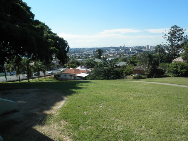
Highgate Hill Park was already a popular lookout and recreation spot prior to its purchase and designation as a park by the South Brisbane City Council in 1903. In the disastrous 1890 and 1893 floods, local residents used the site to view the effects of the floods and operate a flood relief centre. The park contains a band rotunda, constructed circa 1910, and four cast-iron ornamental bollards, possibly from the same era. The park remains substantially intact and has not been considerably altered since the early twentieth century.
Also known as
Highgate Hill Reserve
Lot plan
Key dates
Local Heritage Place Since —
Date of Citation —
Criterion for listing
(A) Historical; (G) SocialInteractive mapping
Also known as
Highgate Hill Reserve
Lot plan
Key dates
Local Heritage Place Since —
Date of Citation —
Criterion for listing
(A) Historical; (G) SocialInteractive mapping
History
Steep and densely wooded at the time of European settlement of Brisbane, the land at Highgate Hill, was, as a result, left undeveloped for many years. By the 1860’s, the hill’s summit, being the highest point in the area, was a popular lookout spot from which to view the expanding settlement of South Brisbane. But the land at the summit, where Dornoch Terrace and Hampstead Road met, was not public land but, in fact, was owned by James Wilson.
During the 1890 and 1893 floods that ravaged South Brisbane, the hill was frequented by sightseers viewing the devastation. It was also used by the residents of ‘Sailors Gully’, that is, the area bounded roughly by Boundary, Brighton and Hampstead Roads, and Dornoch Terrace, to help with flood relief operations. In any case, the land continued to gain the feel of ‘public property’ as far as the local residents were concerned. So on 14 February 1903, the South Brisbane City Council met to formerly acquire the property as a park, despite the apparently high price of 1250 being demanded by James Wilson. His property was purchased at the same time as Mowbray Park, and was an obvious attempt by the South Brisbane City Council to increase its stock of parkland.
A photograph of the park taken circa 1910 shows that the band rotunda had been erected and a simple bench seat was also contained within the park. Around that time the Queen Palms and Moreton Bay Fig trees were planted. The park also experienced a number of name changes, being known at various times as Highgate Hill Reserve, Highgate Hill Lookout and then Highgate Hill Park.
It would appear that while Brisbane City Council maintained the park, it made few changes to the site until 1961. Around this time, porphyry edged garden beds were placed in the park. An oleander garden bed facing Hampstead Road was removed because of residents concerns that it was shielding various criminal activities within the park. Few other changes have occurred to Highgate Hill Park despite a number of proposals, including one in May 1986 to playground equipment and a park sign placed on the site. Thus Highgate Hill Park remains largely as it was at the time of its acquisition.
Description
The Highgate Hill Park is one of the highest landmarks within the area and provides extensive views towards the city, making it a valuable vantage point. The park is on the corner of Dornoch Terrace and Hampstead Road, on a site that slopes down the side of a hill. A large, shady Moreton Bay Fig occupies the corner, while other significant trees that are prominent within the park are Weeping Figs, Hoop Pines, Silky Oaks and Queen Palms. A hedge runs along the Dornoch Terrace edge of the park and timber framing acts as a fence down along Hampstead Road. At the corner of the two streets, porphyry stone retaining walls edge the park boundary, to create a corner entry to the park and terrace up the slope to the foot of the Queen Palms. Three pathways run through and across the park. The two on the steeper slope are concrete, while the other has been maintained with a gravel surface.
A landmark of the site and surrounding area is the band rotunda, which has a corrugated iron roof, moulded timber posts, arching timber sweeps with vertical battening infill and battened timber balustrades. It is noticeable from each boundary of the park. It has been painted in the “heritage colours” of white and deep green. The rotunda opens to both Dornoch Terrace and onto the opposite side to the park, with timber stairs accessing these openings. A timber board ceiling and bench seating articulate the internal space of the rotunda, along with a directional dial in the centre of the space. Various park benches and a picnic table under the fig provide further facilities for the park.
Along the Dornoch Terrace edge of the park are four cast iron ornamental bollards. As with the rotunda these are painted a “heritage colour” deep green that reflects the past and blends into the park vegetation.
Statement of significance
Relevant assessment criteria
This is a place of local heritage significance and meets one or more of the local heritage criteria under the Heritage planning scheme policy of the Brisbane City Plan 2014. It is significant because:
References
-
Brisbane City Council Water Supply & Sewerage Detail Plans
-
Bourboulas, Manuel, Preliminary survey of Highgate Hill Park, QUT: Urban & Regional Planning assignment, 1992
-
Department of Natural Resources, Queensland Certificates of title and other records.
-
JOL Estate Map Collection and photographic collection
-
Lawson, Ronald. Brisbane in the 1890s: a study of an Australian urban society ( St Lucia, Queensland: University of Queensland Press, 1973)
-
McKellar's Map of Brisbane and Suburbs. Brisbane: Surveyor-General’s Office, 1895
Citation prepared by — Brisbane City Council (page revised September 2020)