Addresses
Type of place
Boat ramp / dry dock
Period
Interwar 1919-1939
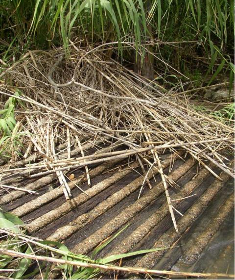

This is an image of the local heritage place known as Ferry ramp
Ferry ramp
Addresses
Type of place
Boat ramp / dry dock
Period
Interwar 1919-1939
A ferry ramp had been in use at this site since 1875 and the present remnants are thought to date from the mid 1920s. The ferry service was an important component in communication between Indooroopilly and Chelmer until the completion of the Walter Taylor Road bridge in 1936.
Lot plan
L1_RP112010
Key dates
Local Heritage Place Since —
Date of Citation —
Construction
StructureCriterion for listing
(A) Historical; (B) Rarity; (C) Scientific; (D) RepresentativeInteractive mapping
Lot plan
L1_RP112010
Key dates
Local Heritage Place Since —
Date of Citation —
Construction
StructureCriterion for listing
(A) Historical; (B) Rarity; (C) Scientific; (D) RepresentativeInteractive mapping
History
The area from Chelmer to Corinda was known as “Boyland’s Pocket” in the 1850s, Captain Boyland having leased the area in 1851. In 1860 the new Queensland Government opened up the district for selection, at a price of 1 pound per acre, resulting in the establishment of a number of farms ranging anywhere between 25 and 70 acres in size. Attempts were made by pioneer selectors during the 1860s and 1870s to produce maize, potatoes, bananas, cotton, sugar cane, and arrowroot. The opening of a railway bridge at Indooroopilly in 1876 reduced the isolation of the area, and allowed for increased subdivision. The first main building wave occurred in the 1880s, a boom period for Brisbane.
Trains running from Ipswich first reached Sherwood in early 1875, and Chelmer later in the year. However, until the railway bridge was operational in 1876, rail passengers crossed the river by means of a punt-ferry, then took another train into the city. After the first Albert Bridge was washed away in the 1893 flood, the punt ferry was again put into use for this purpose, although it probably had continued in use for horseback or foot travellers in the interim.
Photos taken during construction of the of the second Albert bridge, 1895, show a well-formed ferry ramp on the Indooroopilly side, as well as the post to which the punt’s guide-rope was attached. Perhaps it is the same post that stands today, on the downstream side of the top of the ramp.
In 1925 Brisbane Timbers Ltd, the sawmilling operation at Corinda operated by David Lahey, built a powered punt ferry (which still utilised a haul-rope), and this operated until the construction of the Walter Taylor road bridge in 1936. It is likely that the current ramp is a 1920s upgrade of an earlier ramp (the 1926 BCC Minutes mention widening the access road from Radnor St), and the remains of the road to the ramp are still visible.
A long term resident of Indooroopilly, born 1925, has stated that the ramp used to be two cars wide, and extended 6 feet below the water at low tide, but it is gradually deteriorating. Some stabilisation work may be in order. Little remains of the access road and ramp on the Chelmer side.
Statement of significance
Relevant assessment criteria
This is a place of local heritage significance and meets one or more of the local heritage criteria under the Heritage planning scheme policy of the Brisbane City Plan 2014. It is significant because:
References
-
The Brisbane River, A Pictorial History, Robert Longhurst and William Douglas, Chelmer Through the Years 1860 to 1973, Mrs Cyril Bodes
-
Oxley Creek, Settlement. www.brisbane-stories.powerup.com.au
-
Brisbane City Council Minutes, 1925, 1926
-
McKellar's Map of Brisbane and Suburbs. Brisbane: Surveyor-General’s Office, 1895
-
Brisbane City Council Images On-line
-
John Oxley Library/Picture Australia online
-
Fred Whitchurch, Indooroopilly Resident, phone interview 2003
Citation prepared by — Brisbane City Council (page revised June 2022)