Addresses
Type of place
Work residence, Cemetery
Period
Interwar 1919-1939, Victorian 1860-1890
Style
Bungalow
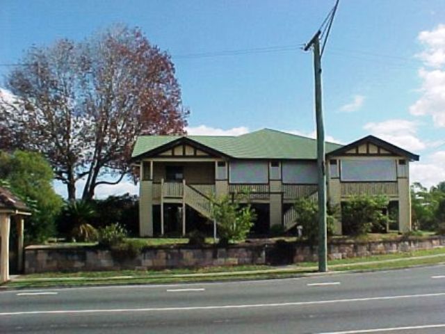

This is an image of the local heritage place known as Sexton's Residence
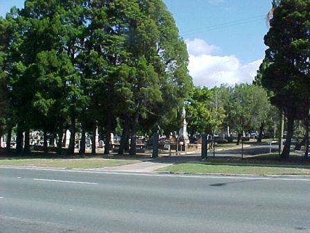
This is an image of the local heritage place known as Lutwyche Cemetery
Lutwyche Cemetery & Sexton's Residence
Addresses
Type of place
Work residence, Cemetery
Period
Interwar 1919-1939, Victorian 1860-1890
Style
Bungalow
Lutwyche Cemetery was established in 1878. Designed in the traditional grid-like layout, popular in the Victorian era, the cemetery is demonstrative of the early European community’s need for burial grounds. The fabric, setting and context of the site are all important. The cemetery has distinct sections which show its evolution from a Victorian cemetery, established in the 1870s, to one that includes newer forms of burial, such as the war and lawn cemeteries. Within the cemetery grounds is an early and intact shelter built in 1891 and the sexton’s residence, a substantial interwar timber house on the corner of Gympie and Kitchener Roads. The cemetery has an important Commonwealth War Graves Commission burial section on the site which contains 386 World War II graves. Mature trees on the site, which include rows of Camphor Laurel and Cypress Pine trees, add to the site’s significance and visual appeal.
Also known as
Kedron Brook Cemetery
Lot plan
L753_SL8480
Key dates
Local Heritage Place Since —
Date of Citation —
Criterion for listing
(A) Historical; (B) Rarity; (D) Representative; (E) Aesthetic; (G) SocialInteractive mapping
Also known as
Kedron Brook Cemetery
Lot plan
L753_SL8480
Key dates
Local Heritage Place Since —
Date of Citation —
Criterion for listing
(A) Historical; (B) Rarity; (D) Representative; (E) Aesthetic; (G) SocialInteractive mapping
History
“Cemeteries not only help explain our past, they also provide a sense of continuity and identity. So our burial grounds reflect vital aspects of our social, religious, folk, architectural, literary and botanical history which are not found in such a combination in any other place.”1
After the declaration of Queensland as a colony, separate to New South Wales, in 1859, the new Queensland Government was anxious to increase the colony’s population and to encourage agricultural settlements. One of the earliest pieces of legislation was the Crown Lands Act 1860 that opened up crown land for sale. Edward Huxtable surveyed the Kedron district on behalf of the Government in 1864. At that time the district was named after the nearest watercourse – Downfall Creek.
The first sale of crown land held in the district occurred on 23 May 1865. This sale attracted no buyers and the next (successful) land sale in the district did not occur until exactly one year later. Many of the early settler/farmers to the district, such as Andrew Hamilton, Joseph Webster, William Murphy, Heinrich Beneke and Wilhelm Fischle gave their names to the tracks that became the district’s roads or streets. The Gympie gold-rush of the late 1860s led to the creation of a shorter route to the goldfields to reduce travelling time. This route crossed the middle of the Downfall Creek District and became Gympie Road. Cobb & Co used Gympie Road for their coach and mail route.
In 1879, the Queensland Government allowed the creation of local authorities to administer the various districts within the colony. The Downfall Creek District became the Nundah Divisional Board in 1880, a huge area that ran from Breakfast Creek to the South Pine River.
The land which the Lutwyche Cemetery now occupies was first purchased in 1865 by early pioneer and farmer, Henry Craig. In 1877, with Craig’s death, this land reverted back to the ownership of the Crown. As the population of the Downfall Creek area increased in this period the need for a local burial ground became apparent to many in the community. This concern was coupled with the closure of the Paddington Cemetery, with the result that the closest burial ground to Downfall Creek was Toowong.
In 1877 a Board of Trustees was formed to plan a cemetery for the inhabitants of the Lutwyche district. A contract to clear the land was given in early 1878. The first recorded burial was that of a five year old boy, interred in August 1878, though the cemetery was not officially gazetted until 1886. The initial Board of Trustees for the cemetery consisted of many prominent community members and was announced in 1877; it included Henry Wheeler, Edward Slaughter, John. L. Bale, Kenneth McLennan, Robert Lane, Robert Thorrold, John Cooper and George Fischer. The cemetery was first known as Kedron Brook Cemetery but the name was changed to Lutwyche Cemetery in commemoration of Judge Lutwyche.
Prior to the late eighteenth and early nineteenth centuries Christian burials were traditionally placed in church yards close to the church, however with the population increase in urban areas caused by the Industrial Revolution, a shift in burial practice occurred. Large open areas of land on the outskirts of settlements were being set aside for burials. This practice not only created pleasant landscaped environments in which monuments could be set out, but was also seen as a cleaner burial practice that moved the graves well out of populated areas. In Australia this practice was adopted as new European settlements were established.
In the Victorian era there were two main cemetery designs. The first was a romantic design that emphasised nature. It incorporated curved pathways often meeting at acute angles and followed the topography of the land. The other design was a grid-like layout. This design was far more formal than the romantic design. It incorporated a rectilinear arrangement with straight lines that defined boundaries and divided the portions and sections within the cemetery. The design of the Lutwyche Cemetery followed the latter form.
In the Victorian tradition of building shelters in the cemetery for the use of visitors during bad weather, the Lutwyche Cemetery Board of Trustees had a timber shelter built within the grounds in 1891. Shelters were generally placed in prominent positions within the cemetery and following this trend the shelter built in Lutwyche Cemetery was situated at what would then have been the middle of the cemetery. The square timber structure was designed by Brisbane architects Voller and Graham.
The architectural firm of Voller and Graham was established in 1891 when Walter Carey Voller and William Edward Graham, established architects in their own right, entered partnership. The partnership lasted just over two years, but produced the design for buildings such as St. Andrew’s Presbyterian Church in Rockhampton. The Lutwyche Cemetery shelter is a very fine example of a gracious, well designed type of shelter designed for one of Brisbane’s earliest cemeteries.
Like many other Victorian era cemeteries, the Lutwyche Cemetery was designed with certain sections devoted to various denominations. There was initially a General Protestant area, a Church of England area and a Roman Catholic area. The oldest part of the cemetery is the first two sections back from Gympie Road. As mentioned, the first burial in the cemetery was the five year old boy, Walter Silcock in 1878. His grave can be found between the shelter and the main drive.
Several early pioneers and prominent members of the community are buried in the earliest part of the cemetery: John Morris, early pioneer in the area was buried in 1891; Thomas Melrose, early farmer and namesake of Melrose Park was buried in 1902; Thomas Bradshaw, owner of the Bradshaw Estate and namesake of Bradshaw Street was buried in 1893; John King, first postmaster of the district and Shire Councillor was buried in 1931; Kenneth McLennan established the homestead Conon and served on the Windsor Shire Council as mayor, he was buried in 1916; Andrew Hamilton was one of the earliest pioneers in the Chermside area and was buried in 1897.
Following Christian tradition, the graves in the Lutwyche cemetery have been laid out facing east. Many of the older graves have a grave surround- a small wrought iron fence around the plot, originally erected to protect the grave from wandering livestock. Many of the older grave stones display traditional Victorian symbols such as angels, scrolls, broken columns, urns draped with shroud clothes.
Traditionally, the tree plantings within a cemetery had symbolic significance. Lutwyche Cemetery displays examples of this. Along the Gympie Road frontage of the cemetery is a row of cypress pines. Pines were planted in cemeteries for their strong vertical lines that were seen to symbolise the elevation of the soul toward heaven. The cypress pine, specifically, was used in cemetery plantings due to the belief that if the tree was cut it would no longer grow, thus symbolising death. Between the row of cypress pines are the front cemetery gates and gate-posts. The pine was preferred as it was an ever-green tree. Other examples of ever-green trees planted in the cemetery are a row of mature Camphor-Laurel trees along the north-east boundary.
The first sexton for the cemetery was Tom Powell. He and his large family lived in a small cottage. The role of a cemetery’s sexton was to maintain the grounds as well as organise the burial plots. Powell retained his position for over thirty years. During the interwar period a larger timber sexton’s residence was built on the corner of Gympie and Kitchener Roads. This residence is still extant. The cemetery was transferred from the control of the Trustees from its establishment to the Brisbane City Council in July 1930.
On 28 November 1942, the Brisbane City Council announced that the soldier’s section at Toowong Cemetery was nearly full and that subsequently any future military deaths would be buried at Lutwyche. Council set aside a special section that was to resemble the post-World War I Gallipoli and French war cemeteries. The war graves section had no walls. There was no tiling around the graves that were to be placed around a central memorial. Initially it was planned that plaques instead of headstones would be the grave markers but this changed. The headstones were rectangular with rounded tops and were differentiated only by the inscriptions that record the national emblem or regimental rank, the name, unit, date of death, age and religious symbol if applicable.
Post-war, the Commonwealth War Graves Commission assumed maintenance of the Cemetery’s War Grave’s Section. The Commission was established during World War I to mark, record and maintain the graves of the British Commonwealth’s casualties. During World War II, the Commission continued to establish war cemeteries throughout the world. The design and symbolism used by the Commonwealth War Commission’s cemeteries retained a singular uniformity. The headstones were rectangular with rounded tops and were differentiated only by the inscriptions that record the national emblem or regimental rank, the name, unit, date of death, age and religious symbol if applicable. In cemeteries of more than 40 burials a Cross of Sacrifice was erected. This war memorial design, by Reginald Blomfield, consisted of a simple cross mounted on an octagonal base. A fine example of a Cross of Sacrifice is in Lutwyche Cemetery. As well as the headstones there is a Queensland Cremation Memorial commemorating 36 Australians killed in the War whose remains were cremated. The area has well maintained gardens with low-growing plants and manicured lawn. The War Graves in Lutwyche Cemetery are rare in Brisbane. The Lutwyche Cemetery has several lawns with the graves of ex-service men and women and their spouses. The cemetery, which covers approximately five hectares, has over 26, 000 burials.
Description
The site is a cemetery reserve owned by the Brisbane City Council with an area of 10.140ha. The cemetery is laid out with a strongly rectangular grid. A row of mature cypress pines line the front fence facing Gympie Road. A row of mature Camphor Laurel trees line the north-east side of the cemetery along Kitchener Road. The older burials are found on the eastern half of the cemetery. The timber shelter was built in 1891 and is an intact example of a Victorian shelter built within the cemetery grounds. The shelter is located on the northern side of the Main Drive through the cemetery. The Commonwealth War Grave Commission’s burial ground is located at the centre of the cemetery.
Statement of significance
Relevant assessment criteria
This is a place of local heritage significance and meets one or more of the local heritage criteria under the Heritage planning scheme policy of the Brisbane City Plan 2014. It is significant because:
References
-
Sagazio, Celestina, “Cemeteries: Their Significance and Conservation” Historic Environment, Vol. 12 No.2, 1996, p13-18
-
Brouwer, Catherine, South Brisbane Cemetery Conservation Plan, June 2002
-
“Commonwealth War Graves Commission”, Wikipedia Entry
-
“Lutwyche Cemetery” Commonwealth War Graves Commission, http://www.cwgc.org/search/cemetery_details.aspx?cemetery=13744&mode=1
-
Teague, DR., The History of Kedron, Colonial Press, 1976
-
McCallum, Beres, A Walk Through Lutwyche Cemetery, Windsor and Districts’ Historical Society, 1997
-
Brisbane City Council, Properties on the Web, website
-
Brisbane City Council, 1946 aerial photographs.
-
Department of Natural Resources, Queensland Certificates of title and other records.
-
Queensland Post Office Directories, 1868-1949
Citation prepared by — Brisbane City Council (page revised September 2020)