Addresses
Type of place
Quarry
Period
Federation 1890-1914, Interwar 1919-1939

This is an image of the local heritage place known as Kedron Shire Quarry Face & Stone Crusher (former) 2
This is an image of the local heritage place known as Kedron Shire Quarry Face & Stone Crusher (former)
This is an image of the local heritage place known as Kedron Shire Quarry Face & Stone Crusher (former) 1
Kedron Shire Quarry Face & Stone Crusher (former)
Addresses
Type of place
Quarry
Period
Federation 1890-1914, Interwar 1919-1939
The Kedron Shire quarry operated from the 1910s, becoming a Brisbane City Council quarry in 1925 after the amalgamation of local councils. The ‘Ruwolt jaw crusher’, a wooden stone crusher, was installed in 1926. The quarry produced a purple and white welded tuff used for building stone and later crushed rock for road pavements and retaining walls. It was closed in 1963 and the site now accommodates a Brisbane City Council Works Depot.
Lot plan
Key dates
Local Heritage Place Since —
Date of Citation —
Criterion for listing
(A) Historical; (B) Rarity; (E) Aesthetic; (G) SocialInteractive mapping
Lot plan
Key dates
Local Heritage Place Since —
Date of Citation —
Criterion for listing
(A) Historical; (B) Rarity; (E) Aesthetic; (G) SocialInteractive mapping
History
The cliff face at the Stafford Quarry is part of a vein of rock which has been an important and useful source of building stone for Brisbane. In geological literature it is described as a Tuff – the Brisbane Tuff – and in the quarry and stonemasons’ trade it is called Porphyry. The result of a violent explosive geological event, Brisbane Tuff is an unusual rock and restricted in occurrence. A linear mass, it runs through the Brisbane area from Stafford, Windsor, Royal Brisbane Hospital, Bowen Hills, Leichhardt Street, Spring Hill, Kangaroo Point, swinging westward through Dutton Park, the University of Queensland, via Six-mile Rocks in the Brisbane River across to Yeronga where it disappears beneath younger beds. Quarries have been developed along the outcrop. Nine quarries have been identified and all are now abandoned. The best known outcrop is the high vertical rock face at Kangaroo Point which was quarried from 1825 until 1976 and was a source of stone for many early buildings and retaining walls in Brisbane including the Commissariat Store (1828-1829) in William Street.
Porphyry is the most striking of the building stones quarried in Brisbane. The stone varies in colour with off-white, pink, purplish and green commonly occurring. It is also found in yellow and brown. Colour seems to be related to durability, the pinks and purples being more durable and the green less durable. The uniformity, porosity and blocky jointing of the tuff make it a good building stone. Brisbane Tuff is not suited to polishing and is generally seen as rough-dressed stone, commonly found in ashlar work and in base courses, retaining walls, side walls and cellars of early buildings. It has been extensively used for roadmaking, kerbing, wharfs and marine walls. Quarries were worked at Spring Hill, Herston and Fortitude Valley to produce stone used in Brisbane General Post Office (1872); St Stephen’s Cathedral (1874); St Paul’s Church, Leichhardt Street (1887); St John’s Cathedral (1909-11).
A welded tuff like the rock at Kangaroo Point, the former Stafford Quarry produced purplish and off-white stone. The early rock was used for building stone and the quarry was then a source of crushed rock for road pavement gravels and boulder stone for landscaping. The Stafford stone has been used mainly for river bank and other retaining walls.
A predominantly rural area with some noxious and light industry until the 1940s, Stafford was known as Happy Valley until 1886. Up until the 1940s it was not a popular residential area with many complaining about the close proximity of dairy farms, the odours from the tanneries, the effluent discharged into Kedron Brook and the dust and explosions erupting from Stafford Quarry. From 1945 to 1961 Stafford experienced a housing boom ignited when the Queensland Housing Commission erected a large number of houses in planned estates from 1945. By the 1950s private developers were beginning to develop estates on the northern boundaries of the Housing Commission area.
Local residents recall that the quarry was operated by the Kedron Shire (thus the quarry was in operation before 1925), and accidents and the installation of equipment were reported in local newspapers from 1913. The rock was blasted away and then smashed with sledge hammers. When the quarry was extended to two levels, one would frequently fill with water and was used at weekends by the locals as a swimming hole.
After the amalgamation of Brisbane’s local councils, the Brisbane City Council took over the quarry’s operation. The stone crusher was installed in 1926, though according to Brisbane’s Daily Standard, not used:
In Nundah Ward is the famous “white elephant” quarry, situated at Stafford-on-Kedron… in July, 1926, Mayor Jolly called for tenders for a stone-crusher for the quarry. The tender of the Runalt [sic] Company, Melbourne, was accepted, the amount being 697. It was delivered in August, 1926, and although 18 months had elapsed it had not turned a wheel. (Daily Standard, 17 February 1928, p6)
The quarry was closed in 1963 as the tuff supplies were exhausted and residential settlement was closing in around the site with the blasts, flying rock and dust from conveyor belts, rock crushing and truck movements affecting the residents.
Description
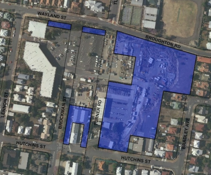
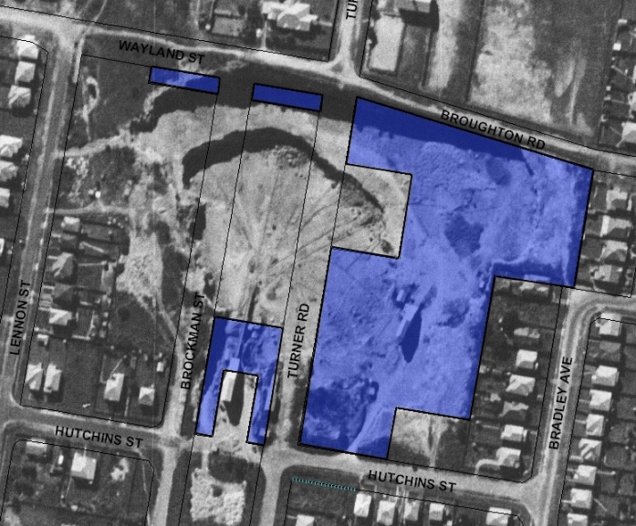
The Stafford Quarry now accommodates a Brisbane City Council Works Depot. The Depot occupies a large irregular flat area bounded by Broughton, Lennon and Hutchins Streets and residential properties fronting Bradley Avenue and Wood Street at Stafford. The quarry is part of a belt of stone, generally less than one kilometre wide, known as Brisbane Tuff or Brisbane Porphyry which runs from Chermside to Dutton Park with a branch through New Farm and Norman Park towards Belmont.
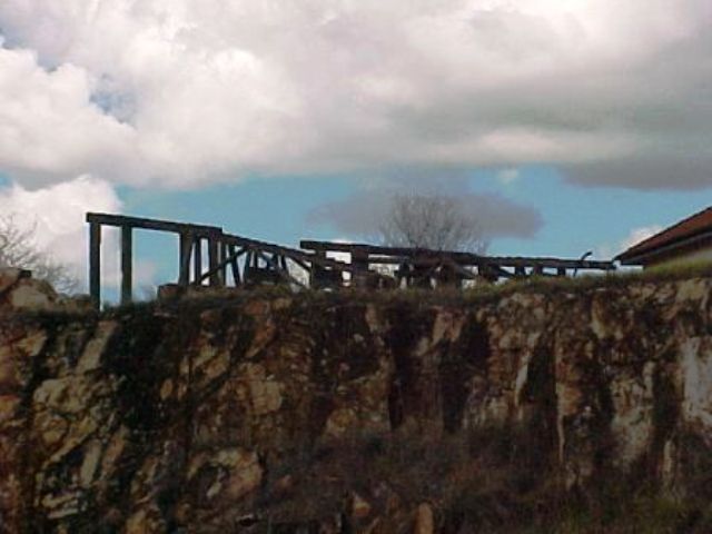
The remaining weathered quarried cliff face runs along the Broughton Street boundary of the Depot and to the rear of the residences fronting Wood Street. The cliff reaches a height of approximately 20 metres along Broughton Street. An early timber and wire fence runs along the top of the cliff in Broughton Street.
Statement of significance
Relevant assessment criteria
This is a place of local heritage significance and meets one or more of the local heritage criteria under the Heritage planning scheme policy of the Brisbane City Plan 2014. It is significant because:
References
-
Brisbane City Council, Stafford Quarry Kedron: Conservation Management Study Site Report, November 2002
-
Brisbane City Council Minutes 1926
Citation prepared by — Brisbane City Council (page revised September 2020)