Addresses
Type of place
Bridge
Period
Interwar 1919-1939
Style
Free Classical
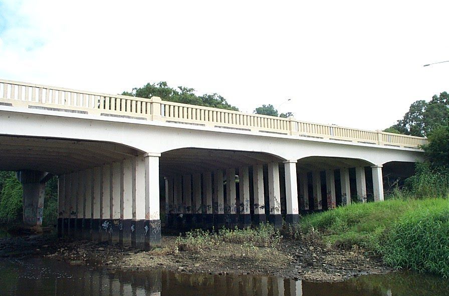

This is an image of the local heritage place known as Normanby Bridge
Normanby Bridge
Addresses
Type of place
Bridge
Period
Interwar 1919-1939
Style
Free Classical
The Normanby Bridge, was built to serve increasing volumes of motorised traffic and the expansion of the northern suburbs. Designed, managed and supervised by the Normanby Bridge Board, it demonstrates the procurement of projects by ad hoc boards. It is an early and largely intact example of a cast-in-situ reinforced concrete bridge, built soon after the development of reinforced concrete technology. It is a simple elegant structure that contributes to the amenity of the Enoggera Creek crossing. It is strongly associated with Brisbane City Engineer Thomas Kirk.
Lot plan
L2_RP41990; L2_RP41991
Geolocation
-27.442951 153.007042
Key dates
Local Heritage Place Since —
Date of Citation —
Construction
StructurePeople/associations
Thomas Kirk (Engineer)Criterion for listing
(A) Historical; (D) Representative; (E) Aesthetic; (F) Technical; (H) Historical associationInteractive mapping
History
In the late 1860s the track to the Gympie goldfields passed through Kelvin Grove and Enoggera, providing the beginnings of Kelvin Grove and Enoggera Roads.
The rapid development in motor vehicle technology and production processes during the 1900s resulted in more efficient, reliable and cheaper vehicles. From less than 2,000 vehicles in 1910, the number of vehicles on Queensland roads increased to 8,000 by 1920 and 91,000 by 1930. The dramatic rise prompted the construction of better roads and regulation of motor vehicle movement.
In Brisbane from the 1920s the impact of the motor vehicle was increasingly evident – new roads were developed and existing ones improved, new bridges were constructed and new services established, all contributing to dramatic changes in patterns of movement and social behaviour which altered patterns of social interaction within the City.
Improvement in roads was matched by an upgrading of bridges and river crossings. The numerous creek and river crossings in the Brisbane metropolitan area necessitated the erection of a number of bridges. Where once simple timber bridges or ferries were sufficient for carriages or wagons, the greater volume and weight of motor vehicles demanded stronger and more substantial bridges.
The earlier of the two existing structures was built for a specific purpose local authority, the Normanby Bridge Board. The Board was typical of the ad hoc boards that were formed prior to the formation of greater Brisbane. These were typically formed to commission specific projects that affected the interests of the whole city or several shires. The Normanby Bridge Board comprised of two aldermen from the Towns of Windsor and Ithaca and two councillors of the Enoggera Shire, Brisbane City Engineer Thomas Kirk and W.T.Jack, Chief Inspector of L.A.L. (Local Authority Loan) Works.
This was at least the third bridge at the site, all probably named Normanby, after George Augustus Constantine Phipps, Marquess of Normanby and Governor of Queensland from 1871-1874. The first bridge may have been built c. 1870. It was rebuilt at the turn of the 20th Century, almost certainly in timber, for horse-drawn vehicles.
This was in turn replaced by the older of the present bridges constructed between 1917-19 at a cost of over £12,000.00 using the then recently developed technology of reinforced concrete, to cater for motorised transport. The Hon. E.G. Theodore, Treasurer and Minister for Works, officially opened the bridge on 30th July 1919.
The 1919 Normanby Bridge stands today but has lost the balustrading to the west in the widening of Kelvin Grove Road.
Description
Built in 1917-19, the Normanby Bridge carries the inbound lanes of Kelvin Grove Road over Enoggera Creek. It carries three vehicular lanes and a footway on the downstream side. A new bridge carrying the outbound lanes has been constructed adjacent to the Normanby Bridge on the upstream side. This report assesses the remaining structure of the 1919 bridge and does not assess the adjacent newer structure.
The deck of the Normanby Bridge is approximately 50m long and 17m wide. The surviving handrail on the downstream side is of 150mm x 100mm rectangular reinforced concrete posts 650mm long cast at 265 centres between concrete top and bottom rails. The bottom rail was originally supported on the footway slab by plinths at 3m centres. The plinths, since filled in to form a continuous dwarf wall, are supported off a 450mm cantilever of the footway slab, of which the underside shape is of a cylindrical quadrant. The handrail spans between ornamental pillars, each lining through with the piers below deck. The handrail is terminated at each end of the bridge by enlarged pillars, which line through with the abutments below. Each of the two enlarged pillars incorporates a marble commemorative plaque. The plaque fixed to the south end of the bridge reads:
NORMANBY BRIDGE
OPENED BY THE
HON. E.C. THEODORE, MLA
TREASURER AND MINISTER FOR WORKS
30 JULY 1919
The marble plaque fixed to the north end of the bridge reads:
1918 NORMANBY BRIDGE BOARD 1918
WINDSOR
ALD- TOM GARDINER PRESIDENT
ALD- R.B. LANE
ITHACA
ALD- J.B. LUGG & FRED HAMPSON
ENOGGERA
CRS- J.F. COLE & M.H. FINLAYSON
THOS- KIRK A.M. I. C. E. W.T. JACK L.A.L. WKS
ENGINEER CHIEF INSPECTOR
S.J. LANG SEC
These plaques were originally duplicated on the opposite (upstream) handrail. However, with the conversion of the bridge to one-way traffic, the original upstream footway was absorbed into the carriageway and its handrail was removed. Its plaques were remounted on concrete plinths at each end of the new bridge’s footway. The handrail itself was replaced with a solid concrete safety barrier.
The deck is supported on reinforced concrete girders at 1.6m centres running parallel to the roadway. The haunches on the outer girders are gently curved and rest on capped posts. The piers comprise a row of eleven tapered reinforced concrete posts.
Two substantial timber pile stumps remain under the southernmost bay of the structure. It is not known whether they are remnants of the first of the three Normanby Bridges or were used in the construction of the 1919 structure.
The citation prepared by the Brisbane City Council Heritage Unit in 2002 notes that the structure appears to be in good condition. It notes that the areas below deck are vulnerable to graffiti attacks.
From the road deck the bridge has suffered visually from the loss of symmetry associated with the removal of the upstream footway and handrail. However below deck, the structure is still intact.
Statement of significance
Relevant assessment criteria
This is a place of local heritage significance and meets one or more of the local heritage criteria under the Heritage planning scheme policy of the Brisbane City Plan 2014. It is significant because:
References
-
Brisbane City Council - City Assets Branch Conservation Management Study Stage 1 Report. November 2002
Citation prepared by — Brisbane City Council (page revised September 2020)