Addresses
Type of place
Sanitary depot, Park
Period
Interwar 1919-1939

This is an image of the local heritage place known as Lota Sanitary Depot (former) & BCC Pound Residence, (Melaleuca Environmental Park)
Lota Sanitary Depot (former) & BCC Pound Residence (Melaleuca Environmental Park)
Addresses
Type of place
Sanitary depot, Park
Period
Interwar 1919-1939
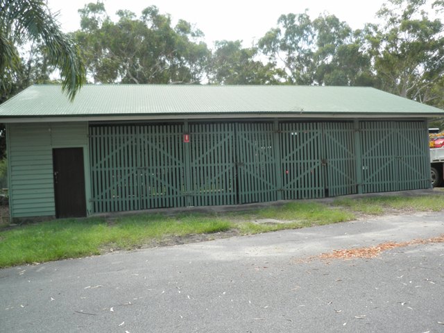
The Former Lota Sanitary Depot with its night soil cart horse stables and wagon garaging, truck garages, vehicle greasing platform, foreman’s cottage and associated dump area are important as surviving visible remnants of the early night soil collection service that operated in the district. The stables and garages buildings are rare surviving examples of this building type. Standing as modest agricultural sheds evocative of a Palladian rural villa idiom, in scale and form the buildings constitute a picturesque feature in a bushland setting.
Lot plan
Key dates
Local Heritage Place Since —
Date of Citation —
Construction
Roof: Corrugated iron;Walls: Timber
Criterion for listing
(A) Historical; (B) Rarity; (D) Representative; (E) AestheticInteractive mapping
Lot plan
Key dates
Local Heritage Place Since —
Date of Citation —
Construction
Roof: Corrugated iron;Walls: Timber
Criterion for listing
(A) Historical; (B) Rarity; (D) Representative; (E) AestheticInteractive mapping
History
Lota was originally named Tingalpa Creek. It acquired its name from the family home in Ireland of William Duckett White’s wife, Jane Simpson. Most of the land at Lota was originally owned by White, who built Lota House there in 1862. Lota is bounded by Moreton Bay to the east and to the south by Lota Creek, which enters the bay near the mouth of Tingalpa Creek.
During the late 19th and early 20th centuries, farms and vineyards dominated the area. By the 1920s most of Lota had been developed, with Lota Estate to the east of the railway line and Lota Park Estate to the West. Lota Heights Estate was in the area bounded by Villiers St and Whites Road, with a reserve zoned for sanitary purposes to the east of it, adjoining Lota Creek. Located in what is today Melaleuca Environmental Park, the site served the purpose of being a burial station for nightsoil as well as being the stables for the horse drawn collection carts.
Work began on Brisbane’s first sewer in 1916. It ran from Toowong to North Quay and then through the Valley and Pinkenba to an outfall at Luggage Point. By 1925 the City centre, East Brisbane, Spring Hill and some adjoining areas were connected to the sewerage system. By the mid-1930s the system had been extended to New Farm, South Brisbane, Highgate Hill, Milton, Woolloongabba, Bowen Hills and Hamilton.
Areas not connected to the sewerage system were serviced by night carts which collected the soil from earth closets and deposited it at sanitary depots located throughout the City. In 1927 there was still a sanitary depot at North Quay. Night soil was trucked in and emptied into large barges which sailed out into the Bay three times a week and deposited their untreated cargo.
The Lota depot dates from at least the early 1920s as a managers residence was built circa 1920 on the corner of Herbert and Empire Avenue. The house still stands and is Council owned. The site contained a land dump which decreased the danger of the waste contaminating water supplies. Such contamination was a source of concern, particularly since the serious health scare of 1934 when an outbreak of typhoid was linked to oysters harvested near the main sewerage outlet at Luggage Point. The Lota Sanitary Depot buildings that can be seen today were constructed c.1936.
In 1938 the sanitary depot’s area was extended by 13.5 acres when Council purchased the land from Mr R.A McIntyre. The extra land served as a buffer area against the encroaching residential expansion in the area and also provided additional burial space, including an exercise ground for the carthorses and a firewood supply.
The financial effects of the Depression and the Second World War slowed extensions to the sewerage system and the collapse of the main sewer at Pinkenba in 1940 was a major setback. After the War, Brisbane was often described as a “sentry box town” and the little red wagons or night carts were a familiar sight. By 1961, night carts still serviced 80% of the Brisbane area.
However the decade 1961-1971 saw massive investment in sewerage infrastructure and by 1973–74 less than 5000 houses in Brisbane would require nightsoil services. Sewerage of the Wynnum - Manly area was completed in 1964, with the depot closing that same year. During 1967 a total of 5 houses were purchased and removed by Council to increase the area of the park. Houses were removed from Keyes Street and Whites Road as well as Hardgreave Street, which no longer exists.
Between 1972 and 1986 the park was called Suncrest Park. In 1980 Council proposed to convert the reserve to a rubbish dump as Wynnum North dump had reached capacity. Local residents formed an action group and successfully petitioned the area to be set aside as a bushland reserve. The park was opened in 1981 by Alderman Don Randall, but was not officially gazetted as a recreation reserve until October 1984.
Melaleuca Park has since been replanted with a variety of native trees. The park’s action group is currently petitioning council to rename it ‘Melaleuca Environmental Park’ in a bid to prevent it being used to host sporting events or playing fields in the future.
Description
The stables, garages, dump area and foreman’s cottage of the former Lota Sanitary Depot are located within the Melaleuca Environment Park, a large area of parkland/ wetland with frontages to Whites Road and Hardgrave, Villiers, Herbert, Empire and Clifton Streets, Lota. The buildings are within the Tingalpa Parks Department Depot located in the northern portion of the park. The Depot is approached from the entrance on Herbert Street. The fenced area to the south of the Depot is the former dump area for the night soil tins.
Description of the buildings based on c.1936 and c.1948 drawings
Drawings for the proposed stables at Lota Sanitary Depot dated 21 January 1936 show a 36.45m long stables and waggon shed building with the north wing 17.85m x 7.8m, the central pavilion 4.2m x 9m and the south wing (including the skillion lean-to) 14.4m x 7.8m.
The north wing has an earthen floor and accommodates an open shed for 3 sanitary waggons (sic) and 2 refuse carts and an enclosed garage for 2 trucks. Ten semi-enclosed horse stalls with a central feeding lane all on a concrete floor are accommodated in the south wing. The skillion lean-to, open to the south and east, accommodates a blacksmith’s shop on an earthen floor. The central pavilion, timber-framed with weatherboard cladding with a hardwood timber floor on timber stumps, houses the feed room to the east and a narrow oil and harness room to the west. The feed room connects with the stables wing opening onto the feeding lane.
The drawings for the garages building to the south are dated 19 November 1948 and show 3 garages to the north and a narrow enclosed pan store to the south. This set of drawings also indicates that alterations were proposed for the stables and wagon shed building at this time including a concrete slab floor to the north wing, a new concrete slab to the south wing, removal of the horse stall partitions and new gates and posts to the openings in both wings.
Descriptions of buildings c.2001 Stables and Waggon Garage Building
The former stables and waggon garaging were accommodated within the longer rectangular single-storey timber framed building standing to the north within the Depot. A gable- roofed centrally projecting pavilion is flanked by long gable- roofed stable wings with a lower skillion-roofed lean-to attaching to the south end. The single-skin weatherboard clad pavilion stands on low timber and concrete stumps and has a central door to the east and west sides. The stable wings have been constructed on bedlogs laid into the ground and have concrete slab floors. The north wing contains six bays of pairs of large battened gates to the east and west sides. The south wing has five bays of paired battened gates to the east and west sides. The skillion lean-to has a pair of battened gates to the east, corrugated metal sheet cladding to the west and a vertical battened screen to the south. The north end of the waggon and cart wing and the south end of the stables wing to the lean-to are clad in single-skin weatherboards. The north stable wing contains a timber halfscreen between the sixth and seventh bays and a full-height timber-framed partition sheeted with corrugated metal stands between bays eight and nine. The south wing contains two rows of notched posts to the centre which may have taken rails and other framing for stable boxes.
Garages
The smaller building to the south of the stables building is a freestanding rectangular timber framed pavilion with a corrugated iron sheeted gable roof. On a concrete slab floor, the building has five bays to the east and west. Four bays bays have large paired battened gates and the south bay is clad with weatherboards. This narrow room accommodated in the south bay is now lined with plasterboard. A full height single skin weatherboard partition separates bays three and four. Two posts stand centrally in line with the external posts in bays 1 to 3.
Vehicle Greasing Ramp and Platform
A timber vehicle greasing ramp and platform stands between the north stables building and south garages building. Two rows of paired 250mm round timber stumps spaced at approximately 1200mm to 1300mm centres support two narrow timber floored ramps which rise to flat timber floored platforms. The ramps and platforms are approximately 2500mm wide.
Dump
The dump site is located south of the Depot and is fenced off and unused.
Foreman’s Cottage
The former foreman’s cottage, a modest verandahed timber cottage, stands to Herbert Street to the west of the entrance to the Depot.
The former stables and garages buildings now house machinery, equipment and building materials. The area to the west of the buildings contains random piles of timber and other building materials and pieces of machinery and equipment. The piles of timber harbour termites and are a hazard to the timber buildings.
A brief visual inspection reveals that the stables and garages buildings have suffered extensive termite damage. In addition, gates have missing and damaged battens. The roofs have recently been re-sheeted in corrugated metal.
The wall framing and weatherboard cladding survive to the c.1936 stables and c.1948 garages buildings. The gates and posts to both buildings are possibly those indicated in c.1948 drawings. In the stables building some evidence of the interior arrangement of the stables to the south wing survives including possible stall posts. A timber half screen partition within the north wing may survive from the earlier waggon and cart accommodation to this wing. There is surviving evidence of an earlier external colour scheme on the central pavilion of the larger building. The c.1948 garages building is one bay larger than indicated on the drawings. The pan store room to the south of the garages building is now lined with plasterboard and accommodates a small office.
The vehicle greasing ramp and platform appears to be in a satisfactory condition. The dump area is presently fenced off and unused.
A brief visual inspection of the foreman’s cottage indicates that parts of the roof sheeting may be in poor condition, some timber cladding and posts have deteriorated and the building requires painting.
Statement of significance
Relevant assessment criteria
This is a place of local heritage significance and meets one or more of the local heritage criteria under the Heritage planning scheme policy of the Brisbane City Plan 2014. It is significant because:
References
-
Brisbane City Council - City Assets Branch Conservation Management Study Stage 1 Report. November 2002
Citation prepared by — Brisbane City Council (page revised September 2020)